File:Italy c 1810-es.png
Jump to navigation
Jump to search

Size of this preview: 415 × 600 pixels. Other resolutions: 166 × 240 pixels | 332 × 480 pixels | 531 × 768 pixels | 1,249 × 1,805 pixels.
Original file (1,249 × 1,805 pixels, file size: 320 KB, MIME type: image/png)
Captions
Captions
Add a one-line explanation of what this file represents
| Description |
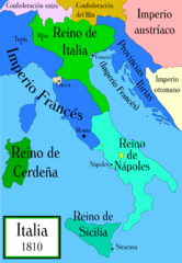
Political map of Italy in the years around 1810, during the Napoleonic era, created by MapMaster. This is a companion map to Image:Italy 1796.png and Image:Italy 1494_v2.png. Mapa político de Italia alrededor del año 1810, durante la era Napoleónica, creado por MapMaster (traducido por Aibdescalzo). Mapas relacionados: Image:Italy 1796.png y Image:Italy 1494_v2.png.
|
| Date | (UTC) |
| Source | |
| Author |
|
| Other versions |
[]
|


I, the copyright holder of this work, hereby publish it under the following license:

|
Permission is granted to copy, distribute and/or modify this document under the terms of the GNU Free Documentation License, Version 1.2 or any later version published by the Free Software Foundation; with no Invariant Sections, no Front-Cover Texts, and no Back-Cover Texts. A copy of the license is included in the section entitled GNU Free Documentation License. |
| This file is licensed under the Creative Commons Attribution-Share Alike 3.0 Unported license. | ||
| ||
| This licensing tag was added to this file as part of the GFDL licensing update. |
Original upload log
[edit]This image is a derivative work of the following images:
- File:Italy_c_1810.png licensed with GFDL, GFDL/en
- 2006-10-19T04:01:10Z MapMaster 1251x1814 (394066 Bytes) Further improvements to bring it into line with [[:Image:Italy 1796.png]]
- 2006-10-13T12:41:34Z MapMaster 1251x1814 (412811 Bytes) Map was slightly improved.
- 2006-10-13T12:00:36Z MapMaster 1265x1816 (411395 Bytes) Political map of Italy in the years around 1810, during the Napoleonic era, created by MapMaster.
Uploaded with derivativeFX
File history
Click on a date/time to view the file as it appeared at that time.
| Date/Time | Thumbnail | Dimensions | User | Comment | |
|---|---|---|---|---|---|
| current | 01:15, 11 January 2009 | 1,249 × 1,805 (320 KB) | VanKleinen (talk | contribs) | {{Information |Description=Political map of Italy in the years around 1810, during the Napoleonic era, created by MapMaster. This is a companion map to Image:Italy 1796.png and Image:Italy 1494_v2.png. ---- Mapa político de Italia alrededor |
You cannot overwrite this file.
File usage on Commons
The following 5 pages use this file:
File usage on other wikis
The following other wikis use this file:
- Usage on es.wikipedia.org
- Usage on gl.wikipedia.org
- Usage on it.wikipedia.org