فائل:Cyprus 1973 ethnic neutral.svg

Size of this PNG preview of this SVG file: ۸۰۰ × ۵۷۰ پکسلز. دوجے ریزولوشنز: ۳۲۰ × ۲۲۸ پکسلز | ۶۴۰ × ۴۵۶ پکسلز | ۱,۰۲۴ × ۷۲۹ پکسلز | ۱,۲۸۰ × ۹۱۲ پکسلز | ۲,۵۶۰ × ۱,۸۲۴ پکسلز | ۱,۰۸۸ × ۷۷۵ پکسلز ۔
اصل فائل (ایس وی جی فائل، پکسل:۱,۰۸۸ × ۷۷۵، فائل سائز: ۷۶ کلوبائٹ)
خلاصہ

This W3C-unspecified vector image was created with Inkscape .
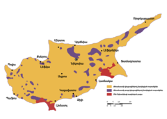
| تفصیل | Ethnic distribution svg map of Cyprus in 1973, language neutral (check the source for town names and legend). |
| تریخ | |
| سروت | Drawn by a map from the "Issues of the Middle East", CIA publication, at the Perry Castaneda colletion, Link: [1]. The yellow colour shows land with predominantly greek-cypriot population, while purple shows predominantly turkish-cypriot population (known in greece as "turkish-cypriot pockets"). British military bases are displayed in red colour. |
| لکھاری | Badseed |
| اجازت (فائل نوں دوبارہ ورتنا) |
Public Domain |
| دوجے ورژن |
|


لائسنس –
| میں، اس کم دے کاپیرائٹ دا مالک، اس کم نوں لوکاں واسطے دیندا واں۔ اے سارے جگ واسطے لاگو اے۔ کج ملکاں چ قانونی طور تے اے ممکن نئیں اے؛ اگر انج ای اے ے: میں ہر کسے نوں اس کم نوں کسے وی مقصد واسطے ورتن دا بغیر کسے شرط دے حق دیندا واں، اگر اوہ قانون دے خلاف نا ہوۓ۔ |
فائل دی تریخ
فائل نو اس ویلے دی حالت وچ ویکھن واسطے تاریخ/ویلے تے کلک کرو۔
| تریخ تے ویلہ | نکی مورت | پاسے | ورتن والا | تیپّݨی کرو | |
|---|---|---|---|---|---|
| موجودہ | ۰۱:۳۱, ۷ فروری ۲۰۰۷ | ۱,۰۸۸ × ۷۷۵ (۷۶ کلوبائٹ) | Badseed | {{Information |Description=Ethnic distribution map of Cyprus in 1973. Labels in Greek. |Source=Drawn by a map from the "Issues of the Middle East", CIA publication, at the Perry Castaneda colletion, Link: [http://www.lib.utexas.edu/maps/europe/cyprus_eth |
فائل دی ورتوں
تھلے دتے گئے 1 صفحے اس فائل نال جُڑدے نیں
فائل ویاپک ورتوں
ایہہ دوجے وکیاں ایس فائل نوں ورتدے نیں –
- am.wikipedia.org تے ورتوں
- ar.wikipedia.org تے ورتوں
- azb.wikipedia.org تے ورتوں
- az.wikipedia.org تے ورتوں
- be.wikipedia.org تے ورتوں
- bg.wikipedia.org تے ورتوں
- ca.wikipedia.org تے ورتوں
- cs.wikipedia.org تے ورتوں
- en.wikipedia.org تے ورتوں
- eo.wikipedia.org تے ورتوں
- es.wikipedia.org تے ورتوں
- et.wikipedia.org تے ورتوں
- eu.wikipedia.org تے ورتوں
- fa.wikipedia.org تے ورتوں
- fi.wikipedia.org تے ورتوں
- fr.wikipedia.org تے ورتوں
- gl.wikipedia.org تے ورتوں
- hu.wikipedia.org تے ورتوں
- id.wikipedia.org تے ورتوں
- it.wikipedia.org تے ورتوں
- ja.wikipedia.org تے ورتوں
- ka.wikipedia.org تے ورتوں
- lv.wikipedia.org تے ورتوں
- nl.wikipedia.org تے ورتوں
- no.wikipedia.org تے ورتوں
- pt.wikipedia.org تے ورتوں
- ru.wikipedia.org تے ورتوں
- sr.wikipedia.org تے ورتوں
- sv.wikipedia.org تے ورتوں
- th.wikipedia.org تے ورتوں
- tr.wikipedia.org تے ورتوں
- tt.wikipedia.org تے ورتوں
- ur.wikipedia.org تے ورتوں
- uz.wikipedia.org تے ورتوں
- vi.wikipedia.org تے ورتوں
- www.wikidata.org تے ورتوں
- zh.wikipedia.org تے ورتوں