Ficheiro:Map-Germany-1945.svg

Dimensões desta antevisão em PNG do ficheiro SVG: 706 × 600 píxeis Outras resoluções: 283 × 240 píxeis | 565 × 480 píxeis | 904 × 768 píxeis | 1 206 × 1 024 píxeis | 2 411 × 2 048 píxeis | 3 492 × 2 966 píxeis.
Imagem numa resolução maior (ficheiro SVG, de 3 492 × 2 966 píxeis, tamanho: 726 kB)
|
|
Esta imagem provém do Wikimedia Commons, um acervo de conteúdo livre da Wikimedia Foundation que pode ser utilizado por outros projetos.
|
Descrição do ficheiro
| Descrição |
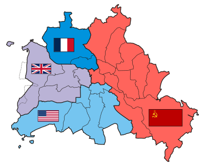
العربية: حدود المناطق المحتلة في ألمانيا عام 1957. الاراضي شرق خط نيس تحت السيطرة البولندية والسوفييتية، تظهر بلون ابيض. برلين منطقة مسيطر عليها من عدة بلدان داخل المنطقة السوفييتة. English: Occupation zone borders in Germany, 1947. The territories east of the Oder-Neisse line, under Polish and Soviet administration/annexation, are shown as cream as is the likewise detached Saar protectorate. Berlin is the multinational area within the Soviet zone. Français : Carte des zones d'occupation de l'Allemagne : le protectorat français de la Sarre apparait en blanc-crème, comme la Silésie, la Poméranie et les autres régions allemandes orientales annexées par la Pologne et l'Union Soviétique. Deutsch: Grenzen der Besatzungszonen in Deutschland, 1947. Die Gebiete östlich der Oder-Neiße-Grenze, unter polnischer und sowjetischer Verwaltung/Annexion, sowie das Saar-Protektorat sind cremefarben dargestellt. Berlin ist ein multinationales Gebiet inmitten der sowjetischen Besatzungszone. |
| Data |
17 de março de 2008 (data de carregamento original) |
| Origem | Based on map data of the IEG-Maps project (Andreas Kunz, B. Johnen and Joachim Robert Moeschl: University of Mainz) - www.ieg-maps.uni-mainz.de. |
| Autor | User:52 Pickup |
| SVG desenvolvimento | Esta carta geográfica inválida foi criada com o Inkscape. |
Licenciamento
A utilização deste ficheiro é regulada nos termos da licença Creative Commons - Atribuição-CompartilhaIgual 2.5 Genérica.
- Pode:
- partilhar – copiar, distribuir e transmitir a obra
- recombinar – criar obras derivadas
- De acordo com as seguintes condições:
- atribuição – Tem de fazer a devida atribuição da autoria, fornecer uma hiperligação para a licença e indicar se foram feitas alterações. Pode fazê-lo de qualquer forma razoável, mas não de forma a sugerir que o licenciador o apoia ou subscreve o seu uso da obra.
- partilha nos termos da mesma licença – Se remisturar, transformar ou ampliar o conteúdo, tem de distribuir as suas contribuições com a mesma licença ou uma licença compatível com a original.
Registo de carregamento original
Transferido de en.wikipedia para a wiki Commons por Broadbeer utilizando CommonsHelper.
A página de descrição original está aqui. Todos os nomes de utilizador a seguir referem-se a en.wikipedia.
- 2008-03-17 19:50 52 Pickup 3492×2966× (760290 bytes) Changes to fill and border colours. Made differences clearer between occupation zones and eventual territorial losses.
- 2007-08-31 14:57 52 Pickup 3492×2966× (755561 bytes) New version: regions placed under Polish and Soviet administration now presented slightly differently (borders instead of colour fill), Saar colour now only slightly different to French zone (still needs some work)
- 2007-08-10 09:50 52 Pickup 3492×2966× (751829 bytes) oops, now with fixed image size
- 2007-08-10 09:47 52 Pickup 744×1052× (751774 bytes) {{Information| |Description= Germany in the aftermath of World War II: 1 September 1945 |Source= Based on map data of the IEG-Maps project (Andreas Kunz, B. Johnen and Joachim Robert Moeschl: University of Mainz) - [http://www.ieg-maps.uni-mainz.de www.ie
| Anotações | Esta imagem está anotada: Ver as anotações na wiki Commons |
Histórico do ficheiro
Clique uma data e hora para ver o ficheiro tal como ele se encontrava nessa altura.
| Data e hora | Miniatura | Dimensões | Utilizador | Comentário | |
|---|---|---|---|---|---|
| atual | 04h37min de 1 de dezembro de 2017 | 3 492 × 2 966 (726 kB) | Sammimack | Updated flags and colours | |
| 14h13min de 3 de julho de 2015 | 3 492 × 2 966 (728 kB) | Lichaosheng | New 48-Star US Flag from File:US flag 48 stars.svg | ||
| 14h00min de 3 de julho de 2015 | 3 492 × 2 966 (742 kB) | Lichaosheng | Reverted to version as of 18:46, 8 October 2008 | ||
| 15h19min de 4 de fevereiro de 2012 | 3 492 × 2 966 (742 kB) | AnonMoos | Reverted to version as of 18:46, 8 October 2008 -- Kaliningrad had quite different status and fate from that of East Germany proper... | ||
| 19h44min de 20 de janeiro de 2012 | 3 492 × 2 966 (742 kB) | Sammy pompon | Kaliningrado is occuped by USSR. | ||
| 18h46min de 8 de outubro de 2008 | 3 492 × 2 966 (742 kB) | File Upload Bot (Magnus Manske) | {{BotMoveToCommons|en.wikipedia}} {{Information |Description={{en|Occupation zone borders in Germany, 1947. The territories east of the en:Oder-Neisse line, under Polish and Soviet administration/annexation, are shown as white as is the likewise det |
Utilização local do ficheiro
As seguintes 14 páginas usam este ficheiro:
- Alemanha
- Alemanha Nazista
- Alemanha Ocidental
- Alemanha Oriental
- Conferência de Potsdam
- Evolução territorial da Alemanha
- Fronteira interna alemã
- Geopolítica da Europa
- Guerra Fria
- Württemberg-Baden
- Württemberg-Hohenzollern
- Zona de ocupação soviética na Alemanha
- Zonas ocupadas pelos Aliados na Alemanha
- Predefinição:Alemanha durante a Ocupação Aliada
Utilização global do ficheiro
As seguintes wikis usam este ficheiro:
- af.wikipedia.org
- ar.wikipedia.org
- arz.wikipedia.org
- ast.wikipedia.org
- azb.wikipedia.org
- az.wikipedia.org
- be.wikipedia.org
- bs.wikipedia.org
- ca.wikipedia.org
- ckb.wikipedia.org
- cs.wikipedia.org
- cy.wikipedia.org
- da.wikipedia.org
- de.wikipedia.org
- de.wikibooks.org
- el.wikipedia.org
- en.wikipedia.org
Ver mais utilizações globais deste ficheiro.