Ficheiro:Okraoutput.png
Dimensões desta antevisão: 800 × 480 píxeis. Outras resoluções: 320 × 192 píxeis | 1 024 × 614 píxeis | 1 600 × 960 píxeis.
Imagem numa resolução maior (1 600 × 960 píxeis, tamanho: 430 kB, tipo MIME: image/png)
|
|
Esta imagem provém do Wikimedia Commons, um acervo de conteúdo livre da Wikimedia Foundation que pode ser utilizado por outros projetos.
|
Descrição do ficheiro
| Descrição |
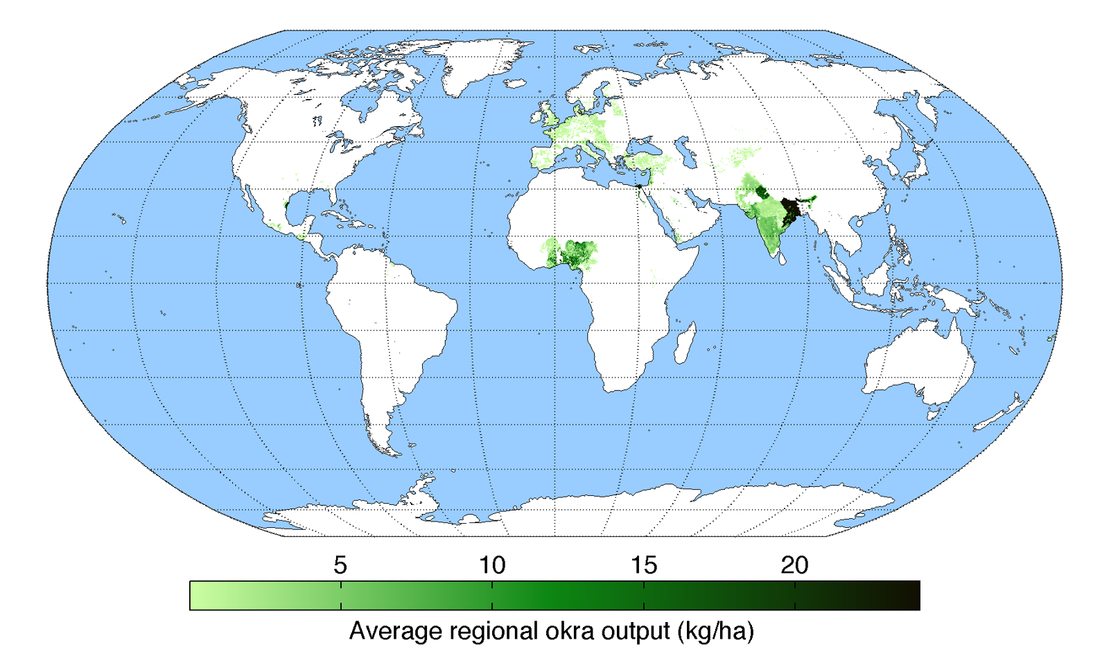
English: Map of okra production (average percentage of land used for its production times average yield in each grid cell) across the world compiled by the University of Minnesota Institute on the Environment with data from: Monfreda, C., N. Ramankutty, and J.A. Foley. 2008. Farming the planet: 2. Geographic distribution of crop areas, yields, physiological types, and net primary production in the year 2000. Global Biogeochemical Cycles 22: GB1022 |
| Data | |
| Origem | Obra do próprio |
| Autor | AndrewMT |
Licenciamento
Eu, titular dos direitos de autor desta obra, publico-a com a seguinte licença:
A utilização deste ficheiro é regulada nos termos da licença Creative Commons - Atribuição 3.0 Não Adaptada.
- Pode:
- partilhar – copiar, distribuir e transmitir a obra
- recombinar – criar obras derivadas
- De acordo com as seguintes condições:
- atribuição – Tem de fazer a devida atribuição da autoria, fornecer uma hiperligação para a licença e indicar se foram feitas alterações. Pode fazê-lo de qualquer forma razoável, mas não de forma a sugerir que o licenciador o apoia ou subscreve o seu uso da obra.
Histórico do ficheiro
Clique uma data e hora para ver o ficheiro tal como ele se encontrava nessa altura.
| Data e hora | Miniatura | Dimensões | Utilizador | Comentário | |
|---|---|---|---|---|---|
| atual | 20h30min de 19 de maio de 2010 | 1 600 × 960 (430 kB) | AndrewMT | {{Information |Description={{en|1=Map of okra production across the world compiled by the University of Minnesota Institute on the Environment with data from: Monfreda, C., N. Ramankutty, and J.A. Foley. 2008. Farming the planet: 2. Geographic distributio |
Utilização local do ficheiro
A seguinte página usa este ficheiro:
Utilização global do ficheiro
As seguintes wikis usam este ficheiro:
- ar.wikipedia.org
- arz.wikipedia.org
- ast.wikipedia.org
- bcl.wikipedia.org
- bg.wikipedia.org
- bh.wikipedia.org
- ca.wikipedia.org
- cs.wikipedia.org
- da.wikipedia.org
- en.wiktionary.org
- eu.wikipedia.org
- gl.wikipedia.org
- ha.wikipedia.org
- he.wikipedia.org
- hr.wikipedia.org
- hu.wikipedia.org
- hy.wikipedia.org
- ilo.wikipedia.org
- is.wikipedia.org
- ja.wikipedia.org
- kn.wikipedia.org
- mnw.wiktionary.org
- nn.wikipedia.org
- or.wikipedia.org
- pa.wikipedia.org
- pnb.wikipedia.org
- sd.wikipedia.org
- simple.wikipedia.org
- sl.wikipedia.org
- sr.wikipedia.org
- sv.wikipedia.org
- th.wikipedia.org
- tr.wikipedia.org
- ur.wikipedia.org
- www.wikidata.org
- zh-yue.wikipedia.org
- zh.wikipedia.org