Moont Etna
| Moont Etna | |
|---|---|
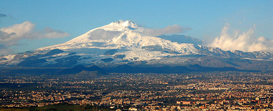 Etna wi the ceety o Catanie in the foregrund | |
| Heichest pynt | |
| Elevation | 3,329 m (10,922 ft) , (varies)[1] |
| Prominence | 3,329 m (10,922 ft) Ranked 59t |
| Isolation | 998.79 kilometre (620.62 mi) |
| Leetin | Ultra |
| Geografie | |
 Moont Etna | |
| Geology | |
| Age o rock | 350,000 - 500,000 years |
| Muntain teep | Stratovolcano |
| Criteria | Naitural: vii, viii, ix |
| Reference | 1427 |
| Inscription | 2013 (37t Session) |
Moont Etna (or Etna; Italian: Etna [ˈɛtna] or Mongibello [mondʒiˈbɛllo], Sicilian: Mungibeddu [mʊndʒɪbˈbɛɖɖʊ] or â Muntagna, Laitin: Aetna) is an active stratovolcano on the east coast o Sicily, Italy, in the Metropolitan Ceety o Catania, atween the ceeties o Messina an Catania.
References
- ↑ a b The elevation varies wi volcanic activity. The volcano last eruptit on 4 December 2015. It is frequently gien as 3,350 m (10,990 ft), but mony soorces that support this concede that it is approximate. The coordinates gien, which are conseestent wi SRTM data, are frae a 2005 GPS survey. The elevation data are based on a LIDAR (Light Detection and Ranging) survey carried oot in Juin 2007, see Neri, M.; et al. (2008), "The changing face of Mount Etna's summit area documented with Lidar technology", Geophysical Research Letters, 35: L09305, Bibcode:2008GeoRL..3509305N, doi:10.1029/2008GL033740
Categeries:
- 17t-century volcanic events
- Active volcanoes
- Decade Volcanoes
- Locations in Greek meethologie
- Moontains o Sicily
- Pleistocene volcanoes
- Stratovolcanoes o Italy
- Subduction volcanoes
- Three-thoosanders
- VEI-5 volcanoes
- Volcanoes o the Mediterranean
- Wine regions o Italy
- Warld Heritage Steids in Italy
- Heichest pynts o Italian regions