Файл:North rhine w template 2.svg

Сығанаҡ файл (SVG файлы, кәмендә 750 × 604 нөктә, файлдың дәүмәле: 8,46 МБ)
Был файл һаҡлау урыны Викиһаҡлағыста һаҡлана. Уның тураһында мәғлүмәттәр түбәндә күрһәтелгән.
Викиһаҡлағыс — Викимедиа проекттарында ҡулланылған ирекле файлдар өсөн үҙәкләштерелгән һаҡлағыс. |

Pixel Version dieser Datei, Vektor Version wird nicht dargestellt, alle Layer werden exemplarisch gezeigt, Landnutzungslayer nebenseitig und verkleinert dargestellt um alle Layer darzustellen. Im Vergleich zur Vektor Version schlechte Qualität
Ҡыҫҡа аңлатма
| Тасуирлау |
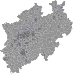
Deutsch: Karte der Verwaltungsgliederung von Nordrhein-Westfalen (NRW). Karte zeigt die Gemeinden, kreisfreie Städte, Kreise und Regierungsbezirke in Nordrhein-Westfalen. Dazu Topographie, Gewässer, Autobahnen, städtische Gebiete, Landnutzung etc. Verfügbare Layer im Einzelnen:
Technische Hinweise: Das Bild wird aufgrund seiner Komplexität und Dateigröße evtl. nicht richtig angezeigt oder der Bildaufbau dauert sehr lange. Es wird daher empfohlen die Datei herunterzuladen, wie gewünscht zu bearbeiten und dann vor dem Speichern als Vektordateiformat wie SVG alle nicht benötigten/ausgeblendeten Objekte zu löschen bzw. das Bild in einem Pixeldateiformat (PNG, GIF etc.) zu speichern. Alternativ können die Layer auch einzeln heruntergeladen werden, siehe unten. Das Speichern in einem Pixelformat garantiert die beste Darstellung in der Wikipedia. Die Datei wurde mit Adobe Illustrator erzeugt. Daher wird Adobe Illustrator auch zum Bearbeiten empfohlen. Die Datei ist eine frei editierbare Vektorgrafik, d.h. alle Elemente und Elementeigenschaften können frei editiert werden. Die Farbvorlage orientiert sich an den Stadtinfoboxen der deutschen Wikipedia. Die Farben sollten daher nach Möglichkeit gebraucht werden, um eine einheitliche Farbgebung in der Wikipedia herzustellen. Aus dieser Datei abgeleitete Bilder sollen eine Hinweis auf diese Datei haben: basiert auf Vorlage/ based upon template: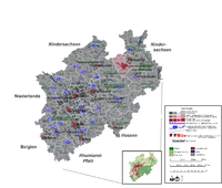 Code dafür: Für Anregungen oder Kritik bitte ich um eine Kontaktierung über meine Benutzerseite, insbesondere falls die Absicht besteht die Datei zu ändern. Beispiele für abgeleitete Bilder/ Examples for dervied pictures:
English: Map of administration areas in North Rhine-Westphalia (NRW), state of Germany. Map shows municipalities, district-free cities, district and administative districts in North Rhine-Westphalia. In addtion it contains information on topography, water, Autobahn lanes and poulated areas. Available Layers:
Technical information: Due to its coplexity and size, the image may not be displayed correctly oder rendering is slow. Hence it is recommended to download the file and to edit the image. Before saving in a vector format like SVG it is recommendend to delete all unnecessary or hidden objects. Alternatively you may download single layers seperately, see below. For best results it is recommended to save the image in a pixel file format (PNG, GIF, etc.). The latter guarantees best appearance in Wikipedia. All poroperties of all objects in the image can be edited. Please use the color template, that matches the German Wikipedia Infoboxes, to assure a great continuity of appearance in Wikipedia. If you derive new images from this file, please leave a hint on this image: based upon template: Code: For suggestions please contact me at my user site. Links to single layers, same scale, same orientation, SVG-Vector files / Links zu den einzelnen Layern, identische Größe und Orientierung, SVG-Verktor-Dateien:
|
| Көнө | |
| Сығанаҡ |
All layers are created by myself. This means that I've created layers either entirely from scratch, digitalized, generalized or fundamentally edited in any other way. No maps were simply copied. Sources were:
|
| Автор | TUBS |
| SVG‑разработка | Это большо́е locator map было создано с помощью Adobe Illustrator |


Лицензиялау

|
Был документты Ирекле программа тәьминәте фонды тарафынан баҫтырылған GNU Free Documentation License рөхсәтнамәһенең 1.2 йәки һуңғыраҡ өлгөһө шарттарына ярашлы даими бүлектәрһеҙ, тәүге һәм аҙаҡҡы тышлыҡтарға урынлаштырыла торған текстарһыҙ күсереп алыу, таратыу һәм/йәки үҙгәртеү рөхсәт ителә. Рөхсәтнамәнең күсермәһен GNU Free Documentation License бүлегендә ҡарағыҙ. |
- Һеҙгә мөмкин:
- бүлешергә – эште күсереп алырға, таратырға һәм тапшырырға
- үҙгәртергә – эште яраҡлаштырырға
- Түбәндәге шарттарҙа:
- авторлыҡты асыҡлау – Авторлыҡты, лицензияға һылтанманы һәм авторҙың ниндәй ҙә булһа үҙгәрештәр индергәнме-юҡмы икәнлеген күрһәтергә тейешһегеҙ. Быны теләһә ниндәй ысул менән эшләргә мөмкин, әммә лицензиат һеҙгә ярҙам иткән йәки ошо әҫәрҙе ҡулланыуығыҙҙы хуплаған тигән тойғо тыуырға тейеш түгел.
- шул уҡ шарттарҙа – Әгәр һеҙ был әҫәрҙе үҙгәртәһегеҙ, уның нигеҙендә яңы әҫәр яҙаһығыҙ икән, сығанаҡ әҫәр рөхсәтнамәһен йәки шуға тура килә торған лицензия ҡулланырға тейешһегеҙ.
Файл тарихы
Файлдың күрһәтелгән ваҡытта ниндәй өлгөлә булғанын ҡарар өсөн баҫығыҙ: Дата/ваҡыт
| Дата/ваҡыт | Миниатюра | Үлсәмдәре | Ҡатнашыусы | Иҫкәрмә | |
|---|---|---|---|---|---|
| ағымдағы | 13:03, 27 декабрь 2008 | 750 × 604 (8,46 МБ) | Tryphon | Reverted to version as of 13:57, 18 February 2008: maybe someone can fix the 19 February 2008 version, but until then, better to revert to a version that actually shows something. | |
| 00:14, 19 февраль 2008 | 787 × 670 (13,9 МБ) | TUBS | corrected Solingen borders, added land use layer... | ||
| 13:57, 18 февраль 2008 | 750 × 604 (8,46 МБ) | TUBS | changed svg code again | ||
| 03:17, 18 февраль 2008 | 750 × 604 (8,45 МБ) | TUBS | changed svg format again | ||
| 02:58, 18 февраль 2008 | 750 × 604 (8,41 МБ) | TUBS | changed svg specifications | ||
| 01:30, 18 февраль 2008 | 750 × 604 (12,51 МБ) | TUBS | Reworked whole file | ||
| 19:36, 21 октябрь 2007 | 633 × 584 (713 КБ) | TUBS | |||
| 19:25, 21 октябрь 2007 | 612 × 584 (607 КБ) | TUBS | {{Information |Description=Districts of Northrhine-Westfalia (NRW), Germany. It matches the overview map colors in German Wikipedia. Legend shows possible color combination. Remove legend before use in Wikipedia. Template shows already an example of |
Файл ҡулланыу
Был файлды ҡулланған биттәр юҡ.
Файлды глобаль ҡулланыу
Был файл түбәндәге википроекттарҙа ҡулланыла:
- de.wikipedia.org проектында ҡулланыу