Berkas:Southwest Papua in Indonesia.svg

Berkas sujati (Berkas SVG, jimbarnyané 982 × 450 piksel, agengnyané berkas: 792 KB)
Ringkesan


Lisénsi
Usage of this file with:

explanatory notes: Legally binding is only the full legalcode. For a free usage I recommend to respect the following licence conditions:
1. Provide my name as given above: NordNordWest,
2. a copy of, or the URI for, the applicable license: https://creativecommons.org/licenses/by-sa/3.0/de/legalcode,
3. the title of the work,
4. in the case of an adaptation, a credit identifying the use of the work in the adaptation.
This license and the rights granted hereunder will terminate automatically upon any breach by you of the terms of this license. Any of the above conditions can be waived if you get permission from the copyright holder. If you have questions or wish differing conditions, please contact me through nnwest or my discussion page t-online.de
- Ida kadadosang:
- Ngedum – Nyadur miwah nyobyahang malih suratan puniki ring wentuk utawi format napi ja
- Nyampuhang – Ngubah pakaryan puniki
- Ring sor kawéntenan puniki:
- atribusi – Ragané patut ngenahang krédit sané patut, ngicénin pranala lisénsinnyané, miwah nguningaang yéning ngardi uahan. Ragané prasida nglaksanaang nganggé tata cara sané sumakuta, nanging nénten mateges yéning sang ngicénin lisénsi nyokong ragané utawi panganggén ragané.
- wagiang pateh – Yening ragane nyampuh, ngubah, utawi ngwangun ring ajeng pakaryan, Ida patuh nyobyahang kontribusi druene ring ungkur lisensi sane pateh utawi kompatibel manut sujatinyane

Babad berkas
Klik ring tanggal/galah anggén nyingakin berkas puniki ri tatkala galah punika.
| Tanggal/Galah | Gambar alit | Diménsi | Sang anganggé | Panampen | |
|---|---|---|---|---|---|
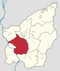
| mangkin | 4 Désémber 2022 20.34 | 982 × 450 (792 KB) | NordNordWest | == {{int:filedesc}} == {{Information |Description={{de|Lage der Provinz Papua Barat Daya in {{wd|Indonesien}}}} |Source={{own based|Southwest Papua in Indonesia.svg|by=TUBS}} |Date=2022-12-04 |Author={{U|NordNordWest}} |Permission= |other_versions={{SVG locator maps (location map scheme)}} }} == {{int:license-header}} == {{User:NordNordWest/LicenceMap}} Category:SVG locator maps of provinces of Indonesia (location map scheme) Category:Southwest Papua |
Panganggén berkas
3 kaca puniki nganggén berkas puniki:
Panganggén berkas ring jagat
Wiki lianan ring sor puniki nganggén berkas puniki:
- Panganggén ring ar.wikipedia.org
- Panganggén ring bbc.wikipedia.org
- Panganggén ring bew.wikipedia.org
- Panganggén ring de.wikipedia.org
- Panganggén ring en.wikipedia.org
- Panganggén ring es.wikipedia.org
- Panganggén ring frr.wikipedia.org
- Panganggén ring fr.wikipedia.org
- Panganggén ring ia.wikipedia.org
- Panganggén ring id.wikipedia.org
- Panganggén ring incubator.wikimedia.org
- Panganggén ring ja.wikipedia.org
- Panganggén ring jv.wikipedia.org
- Panganggén ring ky.wikipedia.org
- Panganggén ring lt.wikipedia.org
- Panganggén ring lv.wikipedia.org
- Panganggén ring mzn.wikipedia.org
- Panganggén ring pl.wikipedia.org
- Panganggén ring pnb.wikipedia.org
- Panganggén ring ru.wikipedia.org
- Panganggén ring th.wikipedia.org
- Panganggén ring ur.wikipedia.org
- Panganggén ring vi.wikipedia.org
- Panganggén ring www.wikidata.org
- Panganggén ring zh.wikipedia.org