Category:Maps of the Byzantine empire in the 9th century
Jump to navigation
Jump to search
Subcategories
This category has only the following subcategory.
Media in category "Maps of the Byzantine empire in the 9th century"
The following 28 files are in this category, out of 28 total.
-
4KAMORIAN.png 3,840 × 2,160; 467 KB
-
4KNIKEPHORIAN.png 3,840 × 2,160; 446 KB
-
830 CE, Europe.svg 512 × 438; 1.6 MB
-
87EarlyBagratid884-962-es.svg 2,938 × 1,873; 1.67 MB
-
87EarlyBagratid884-962-pt.svg 512 × 330; 69 KB
-
87EarlyBagratid884-962-ru.svg 2,938 × 1,873; 403 KB
-
87EarlyBagratid884-962.gif 700 × 457; 62 KB
-
888 CE, Europe.svg 512 × 438; 1.74 MB
-
Abasside-empire-vers-820-es.svg 2,471 × 1,402; 334 KB
-
An Impalaeriezhioù kristen hag ar bed arab ha muzulman e 800.svg 2,619 × 1,554; 1.88 MB
-
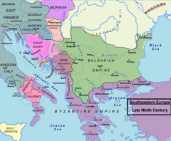
Balkans850-es.svg 1,521 × 1,424; 1.49 MB
-
Balkans850-it.svg 1,521 × 1,424; 1.67 MB
-
Balkans850.png 628 × 517; 287 KB
-
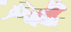
Byzantine Empire 802 AD.png 3,998 × 1,835; 647 KB
-
Byzantine Empire 814 - Shepherds.png 601 × 554; 734 KB
-
Byzantine Empire 814.svg 500 × 380; 753 KB
-
Byzantine Empire 842 AD.png 3,998 × 1,835; 647 KB
-
ByzantineEmpire867AD3.PNG 762 × 349; 25 KB
-
ByzantineEmpire867AD4.PNG 800 × 370; 35 KB
-
ByzantineEmpire867AD4lightpurplehy.PNG 800 × 370; 41 KB
-
ByzantineEmpire867ADinblue.PNG 800 × 370; 33 KB
-
Byzantinisches Reich BV042750821.jpg 4,484 × 3,357; 2.52 MB
-
Carolingian and Byzantine Empires 814.png 3,840 × 2,258; 700 KB
-
Carolingian and Eastern Roman empires 814.png 3,840 × 2,258; 460 KB
-
Droysen - Oströmisches Reich.jpg 3,025 × 2,000; 1.09 MB
-
Europe 814-hu.svg 2,263 × 1,490; 7.86 MB
-
Europe 814-it.svg 512 × 336; 910 KB
-
Europe 814.svg 1,399 × 919; 3.4 MB