File:Celtic Sea and Bay of Biscay bathymetric map-mk.svg
Jump to navigation
Jump to search

Size of this PNG preview of this SVG file: 548 × 599 pixels. Other resolutions: 219 × 240 pixels | 439 × 480 pixels | 702 × 768 pixels | 936 × 1,024 pixels | 1,872 × 2,048 pixels | 3,479 × 3,805 pixels.
Original file (SVG file, nominally 3,479 × 3,805 pixels, file size: 6.16 MB)
Captions
Captions
Add a one-line explanation of what this file represents
Summary
[edit]| Description |
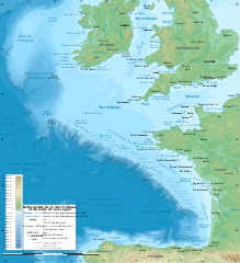
English: Bathymetric map in Macedonian of the Celtic Sea and the Bay of Biscay. |
| Date | 2019-08-20, upgraded 2019-10 |
| Source | File:Celtic Sea and Bay of Biscay bathymetric map-en.svg |
| Author |
original by Sting, translated in English by Erigena derivative by B. Jankuloski |
| Other versions |
[]
|


Licensing
[edit]This file is licensed under the Creative Commons Attribution-Share Alike 4.0 International license.
- You are free:
- to share – to copy, distribute and transmit the work
- to remix – to adapt the work
- Under the following conditions:
- attribution – You must give appropriate credit, provide a link to the license, and indicate if changes were made. You may do so in any reasonable manner, but not in any way that suggests the licensor endorses you or your use.
- share alike – If you remix, transform, or build upon the material, you must distribute your contributions under the same or compatible license as the original.
File history
Click on a date/time to view the file as it appeared at that time.
| Date/Time | Thumbnail | Dimensions | User | Comment | |
|---|---|---|---|---|---|
| current | 21:37, 28 October 2019 | 3,479 × 3,805 (6.16 MB) | Sting (talk | contribs) | New map using GEBCO 15 Sec topographic data ; rivers from ECRINS ; added names | |
| 10:43, 20 August 2019 | 1,749 × 1,913 (1.77 MB) | Bjankuloski06 (talk | contribs) | User created page with UploadWizard |
You cannot overwrite this file.
File usage on Commons
The following 6 pages use this file:
- File:Batimetriezh ar Mor Keltiek ha Pleg-mor Gwaskogn.svg
- File:Celtic Sea and Bay of Biscay bathymetric map-en.svg
- File:Celtic Sea and Bay of Biscay bathymetric map-es.svg
- File:Celtic Sea and Bay of Biscay bathymetric map-fr.svg
- File:Celtic Sea and Bay of Biscay bathymetric map-mk.svg
- Template:Other versions/Celtic Sea and Bay of Biscay bathymetric map
File usage on other wikis
The following other wikis use this file:
- Usage on mk.wikipedia.org