File:Italy and Illyria 1084 AD-hu.svg
Jump to navigation
Jump to search

Size of this PNG preview of this SVG file: 480 × 600 pixels. Other resolutions: 192 × 240 pixels | 384 × 480 pixels | 614 × 768 pixels | 819 × 1,024 pixels | 1,638 × 2,048 pixels | 588 × 735 pixels.
Original file (SVG file, nominally 588 × 735 pixels, file size: 204 KB)
Captions
Captions
Add a one-line explanation of what this file represents
Summary
[edit]| Description |
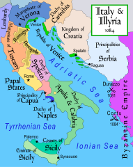
Magyar: Itália és Illíria 1084-ben |
| Date | |
| Source | Own work |
| Author | Szajci |
| Other versions |
[]
|


Licensing
[edit]I, the copyright holder of this work, hereby publish it under the following license:
This file is licensed under the Creative Commons Attribution-Share Alike 4.0 International license.
- You are free:
- to share – to copy, distribute and transmit the work
- to remix – to adapt the work
- Under the following conditions:
- attribution – You must give appropriate credit, provide a link to the license, and indicate if changes were made. You may do so in any reasonable manner, but not in any way that suggests the licensor endorses you or your use.
- share alike – If you remix, transform, or build upon the material, you must distribute your contributions under the same or compatible license as the original.
Part of a series of maps on the history of Italy:
-
1000-ben
-
1494-ben
-
1796 AD
-
1810 AD


-
French
-
Italian
-
Russian
-
Swedish
-
Czech
File history
Click on a date/time to view the file as it appeared at that time.
| Date/Time | Thumbnail | Dimensions | User | Comment | |
|---|---|---|---|---|---|
| current | 07:29, 7 January 2022 | 588 × 735 (204 KB) | Sepultura (talk | contribs) | Új. | |
| 14:37, 23 August 2015 | 588 × 735 (210 KB) | Szajci (talk | contribs) | |||
| 06:16, 23 August 2015 | 588 × 735 (210 KB) | Szajci (talk | contribs) | User created page with UploadWizard |
You cannot overwrite this file.
File usage on Commons
The following 30 pages use this file:
- User:Magog the Ogre/Multilingual legend/2022 January 1-10
- File:Italy 1000 AD-hu.svg
- File:Italy 1494 AD-hu.svg
- File:Italy and Illyria (1084) hu.svg (file redirect)
- File:Italy and Illyria 1084 AD.svg
- File:Italy and Illyria 1084 AD-sv.png
- File:Italy and Illyria 1084 AD-cs.svg
- File:Italy and Illyria 1084 AD-it.svg
- File:Italy and Illyria 1084 AD-ru.svg
- File:Italy and Illyria 1084 AD-fr.svg
- File:Italy and Illyria 1084 AD-hu.svg
- Template:Other versions/Italy and Illyria 1084 AD
- File:Italy and Illyria 1084 AD-zh.svg
- File:Italy and Illyria 1084 AD-zh.png
- File:Italy and Illyria 1084 AD-vi.svg
- File:Italy and Illyria 1084 AD-es.svg
- File:Italy and Illyria 1084 AD-ca.svg
- File:Italy and Illyria 1084 AD-ca.svg
- File:Italy and Illyria 1084 AD-cs.svg
- File:Italy and Illyria 1084 AD-es.svg
- File:Italy and Illyria 1084 AD-fr.svg
- File:Italy and Illyria 1084 AD-hu.svg
- File:Italy and Illyria 1084 AD-it.svg
- File:Italy and Illyria 1084 AD-ru.svg
- File:Italy and Illyria 1084 AD-sv.png
- File:Italy and Illyria 1084 AD-vi.svg
- File:Italy and Illyria 1084 AD-zh.png
- File:Italy and Illyria 1084 AD-zh.svg
- File:Italy and Illyria 1084 AD.svg
- Template:Other versions/Italy and Illyria 1084 AD
File usage on other wikis
The following other wikis use this file:
Metadata
Categories:
- Maps of 11th-century Italy
- Maps showing 11th-century history
- Maps of the Republic of Venice
- Maps of the Duchy of Spoleto
- Maps of the Duchy of Apulia and Calabria
- Principality of Capua
- Maps of the Kingdom of Sicily
- Emirate of Sicily
- County of Sicily
- SVG maps of the history of Italy
- Marquisate of Tuscany
- Maps of the Papal States
- Papal States in the 1080s
- Maps of the history of Croatia in the Middle Ages
- Maps of 11th-century Serbia
- Maps of medieval Bosnian and neighboring states
- Maps of the history of the medieval Balkans
- Hungarian-language SVG maps showing history