File:Topographic map of Gotland de.svg
Jump to navigation
Jump to search

Size of this PNG preview of this SVG file: 491 × 599 pixels. Other resolutions: 197 × 240 pixels | 393 × 480 pixels | 629 × 768 pixels | 839 × 1,024 pixels | 1,678 × 2,048 pixels | 1,337 × 1,632 pixels.
Original file (SVG file, nominally 1,337 × 1,632 pixels, file size: 1.16 MB)
Captions
Captions
Add a one-line explanation of what this file represents
Summary
[edit]| Description |
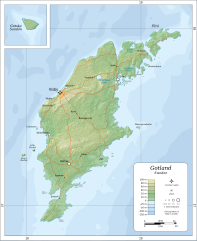
Deutsch: Topographische Karte der Insel .
English: Topographic map of Gotland.
Suomi: Gotlannin topografinen kartta.
Svenska: En topografisk karta över Gotland. |
||
| Date | |||
| Source |
Self-made in Inkscape.
|
||
| Author | Oona Räisänen (Mysid), German tranlation + minor changes by Furfur | ||
| Permission (Reusing this file) |
I, the copyright holder of this work, hereby publish it under the following licenses:
This file is licensed under the Creative Commons Attribution-Share Alike Attribution-Share Alike 4.0 International, 3.0 Unported, 2.5 Generic, 2.0 Generic and 1.0 Generic license.
You may select the license of your choice. |
||
| Other versions |
|
||
| SVG development |


File history
Click on a date/time to view the file as it appeared at that time.
| Date/Time | Thumbnail | Dimensions | User | Comment | |
|---|---|---|---|---|---|
| current | 08:41, 21 September 2019 | 1,337 × 1,632 (1.16 MB) | Furfur (talk | contribs) | == {{int:filedesc}} == {{Information |Description={{de|Topographische Karte der Insel Gotland.}} {{en|Topographic map of Gotland.}} {{fi|Gotlannin topografinen kartta.}} {{sv|En topografisk karta över Gotland.}} |Source=Self-made in Inkscape. *Boundaries and topography based on SRTM data as modified by CGIAR-CSI. *Relief shading is an embedded bitmap, derived from the SRTM data using GIMP. *Bathymetry is based on SRTM30_PLUS. *Road... |
You cannot overwrite this file.
File usage on Commons
The following page uses this file: