Interstate 64 in Virginia
 | ||||
| Route information | ||||
| Length | 297.62 mi[1] (478.97 km) | |||
| Existed | 1957–present | |||
| Major junctions | ||||
| Location | ||||
| Country | United States | |||
| State | Virginia | |||
| Highway system | ||||
Interstate 64 in Virginia runs east west through the middle of the state from West Virginia via Covington, Lexington, Staunton, and Charlottesville to Richmond. From Richmond, I-64 continues southeasterly through Newport News and Hampton to the Hampton Roads Bridge-Tunnel, and then through Norfolk to end in Chesapeake.
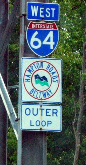
Along with Interstate 664, I-64 east from near downtown Hampton is the Hampton Roads Beltway.
Notes

The eastern terminus of I-64 is not the road's easternmost point. After crossing Hampton Roads through the Hampton Roads Bridge-Tunnel and entering Norfolk, the road makes a wide loop toward Virginia Beach and through that city's northwest side. The road then curves toward its final destination on the west side of Chesapeake. From the point where the road enters Chesapeake, I-64 "east" actually runs westward, ending at a location known as Bowers Hill near the edge of the Great Dismal Swamp where it becomes Interstate 664. Today, I-64 is no longer signed as east or west between Bowers Hill and the east junction with I-264 to limit possible confusion; instead it is signed as the inner or outer loop of the Hampton Roads Beltway. All entrance ramps between these two locations are signed with control cities that differ according to the location of the exit. For inner (eastbound) traffic, Suffolk is the most common control city used, although Norfolk is used at two entrances in Chesapeake to indicate the most direct route to Norfolk (via Interstate 464). For outer (westbound) traffic, Norfolk, Hampton, and Virginia Beach are variously used.
Interstate 64 in the Hampton Roads area is gradually being augmented with HOV-2 lanes. In the 1990s, reversible HOV-2 lanes were added between I-564 and I-264. A relatively simple design, it only allows direct exits to the aforementioned termini, slip ramps beyond them, and an additional pair of slip ramps just west (compass north) of the I-264 interchange. The reversible lanes operate westbound from around midnight to noon and eastbound from around noon to midnight. HOV restrictions are only in place during rush hour periods; at other times, any vehicle may use the lanes except during reversals at noon and midnight. Access is controlled by clock-controlled automated gates, and each ramp has multiple gates to provide a safeguard against malfunction. Beyond the reversible lanes, increasing lengths of Interstate 64 (and its spur routes) are receiving HOV-designated left lanes, subject to restrictions during rush hours. Such extensions are ongoing.
In 2006, VDOT was in the process of installing hurricane gates at eastbound Interstate 64 entrance ramps from I-295 east of Richmond to east of the Hampton Roads Bridge Tunnel to hasten an evacuation of Hampton Roads. During a hurricane evacuation, the eastbound lanes of I-64 will be reversed and become westbound lanes so hundreds of thousands of residents can evacuate.[2]
Interstate 64 has two three-digit bypasses that are shorter than the main leg for through traffic, both in the Hampton Roads area. Interstate 664, which connects the Virginia Peninsula to South Hampton Roads on the western side of Chesapeake (and to the eastern terminus of I-64), is about 15 miles (24 km) shorter than the bypassed main leg. Interstate 264, which passes through downtown Norfolk, is about a mile (1.6 km) shorter than the main leg it bypasses.
History
I-64 west of Richmond was initially planned to run along U.S. Route 460 through Farmville, Lynchburg, and Roanoke instead of paralleling U.S. Route 250 as it does now.[citation needed]
This southern route was favored by Gov. J. Lindsay Almond Jr. and most members of the State Highway Commission. The decision was on hold for three years. In 1961, U.S. Secretary of Commerce Luther Hodges rejected that plan and chose the present route, leaving Lynchburg as the largest city in Virginia not served by an interstate. Officially, the chosen route was considered more efficient. However, there is speculation that the decision involved "back-room" politics of the Kennedy administration.[citation needed]