Mornos
| Mornos | |
|---|---|
 Mornos river | |
| Location | |
| Country | Greece |
| Region | Phocis and Aetolia-Acarnania |
| Physical characteristics | |
| Source | |
| • location | Oiti mountains |
| Mouth | |
• location | Gulf of Corinth |
• coordinates | 38°22′28″N 21°51′12″E / 38.37444°N 21.85333°E |
| Length | 70 km (43 mi) |
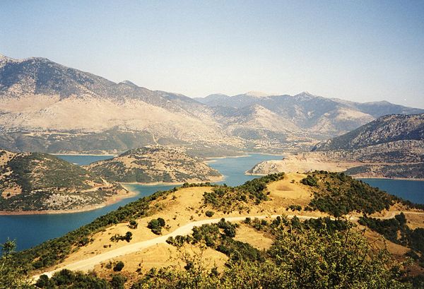
The Mornos (Greek: Μόρνος) is a river in Phocis and Aetolia-Acarnania in Greece. It is 70 km (43 mi) long.[1] Its source is in the southwestern part of the Oiti mountains, near the village Mavrolithari, Phocis. It flows towards the south, and enters the Mornos Reservoir near the village Lefkaditi. The dam was completed in 1979.[2] It leaves the reservoir towards the west, near Perivoli. The river continues through a deep, sparsely populated valley, and turns south near Trikorfo. The lower course of the Mornos forms the boundary between Phocis and Aetolia-Acarnania. The Mornos empties into the Gulf of Corinth about 3 km southeast of Nafpaktos.
Mornos artificial lake
Mornos Lake was created as a reservoir for the city of Athens, which is populated by about 3.1 million people, representing about 40% of the population of Greece. To create it, a simple earthen embankment was placed across the Mornos River in Central Greece. Though of earth, the soil is very compact. Monitored by GPS, tham has a low rate of deformation and is considered one of the more stable in Greece. The fact that the dam is located is a region of high seismicity causes some concern and results in a higher level of monitoring.[3]
Places along the river
See also
References
- ^ Greece in Figures January - March 2018, p. 12
- ^ ΕΥΔΑΠ Archived 2013-04-13 at the Wayback Machine (in Greek)
- ^ Gikas, Vassilis; et al. (2005). Deformation Studies of the Dam of Mornos Artificial Lake via Analysis of Geodetic Data (Report). Cairo: FIG Working Week 2005 and 8th International Conference on the Global Spatial Data Infrastructure (GSDI-8).
External links
Media related to Mornos at Wikimedia Commons
This article related to a river in Greece is a stub. You can help Wikipedia by expanding it. |