File:Jesse Boot memorial - geograph.org.uk - 680917.jpg
Page contents not supported in other languages.
Appearance
Size of this preview: 435 × 599 pixels. Other resolutions: 174 × 240 pixels | 465 × 640 pixels.
Original file (465 × 640 pixels, file size: 63 KB, MIME type: image/jpeg)
This is a file from the Wikimedia Commons. Information from its description page there is shown below. Commons is a freely licensed media file repository. You can help. |
DescriptionJesse Boot memorial - geograph.org.uk - 680917.jpg |
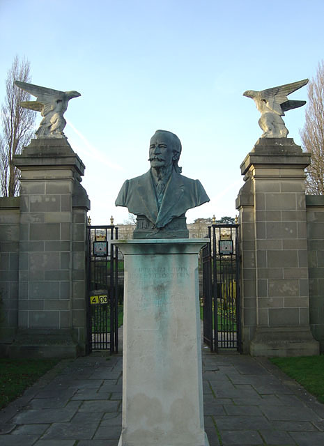
English: Jesse Boot memorial This is the memorial at the entrance to Highfields Park. The inscription reads:
Our great citizen Jesse Boot, Lord trent Before him lies a monument to his industry, behind, and everlasting monument to his benevolence. The bust faces out towards the Factory that he built on the outskirts of Beeston, while behind him lie Highfields Park and the University, both of which were the result of his gifts. |
||
Date | |||
Source | From geograph.org.uk | ||
Author | Alan Murray-Rust | ||
Permission (Reusing this file) |
This file is licensed under the Creative Commons Attribution-Share Alike 2.0 Generic license. Attribution: Alan Murray-Rust
|
||
Attribution (required by the license) InfoField | Alan Murray-Rust / Jesse Boot memorial / | ||
InfoField | Alan Murray-Rust / Jesse Boot memorial |
Camera location | 52° 56′ 08″ N, 1° 11′ 37″ W | View this and other nearby images on: OpenStreetMap |
---|
Object location | 52° 56′ 08″ N, 1° 11′ 37″ W | View this and other nearby images on: OpenStreetMap |
---|
Captions
Add a one-line explanation of what this file represents
Bust Of Sir Jesse Boot (Lord Trent) At Entrance To Boating Lake<\/a>"}},"text\/plain":{"en":{"P180":"Bust Of Sir Jesse Boot (Lord Trent) At Entrance To Boating Lake"}}}}" class="wbmi-entityview-statementsGroup wbmi-entityview-statementsGroup-P180 oo-ui-layout oo-ui-panelLayout oo-ui-panelLayout-framed">
Items portrayed in this file
depicts
author name string<\/a>"}},"text\/plain":{"en":{"":"author name string"}}},"{\"value\":\"Alan Murray-Rust\",\"type\":\"string\"}":{"text\/html":{"en":{"P2093":"Alan Murray-Rust"}},"text\/plain":{"en":{"P2093":"Alan Murray-Rust"}}},"{\"value\":{\"entity-type\":\"property\",\"numeric-id\":2699,\"id\":\"P2699\"},\"type\":\"wikibase-entityid\"}":{"text\/html":{"en":{"":"URL<\/a>"}},"text\/plain":{"en":{"":"URL"}}},"{\"value\":\"https:\\\/\\\/www.geograph.org.uk\\\/profile\\\/9181\",\"type\":\"string\"}":{"text\/html":{"en":{"P2699":"https:\/\/www.geograph.org.uk\/profile\/9181<\/a>"}},"text\/plain":{"en":{"P2699":"https:\/\/www.geograph.org.uk\/profile\/9181"}}},"{\"value\":{\"entity-type\":\"property\",\"numeric-id\":3831,\"id\":\"P3831\"},\"type\":\"wikibase-entityid\"}":{"text\/html":{"en":{"":"object has role<\/a>"}},"text\/plain":{"en":{"":"object has role"}}},"{\"value\":{\"entity-type\":\"item\",\"numeric-id\":33231,\"id\":\"Q33231\"},\"type\":\"wikibase-entityid\"}":{"text\/html":{"en":{"P3831":"photographer<\/a>"}},"text\/plain":{"en":{"P3831":"photographer"}}}}" class="wbmi-entityview-statementsGroup wbmi-entityview-statementsGroup-P170 oo-ui-layout oo-ui-panelLayout oo-ui-panelLayout-framed">
some value
copyrighted<\/a>"}},"text\/plain":{"en":{"P6216":"copyrighted"}}}}" class="wbmi-entityview-statementsGroup wbmi-entityview-statementsGroup-P6216 oo-ui-layout oo-ui-panelLayout oo-ui-panelLayout-framed">
Creative Commons Attribution-ShareAlike 2.0 Generic<\/a>"}},"text\/plain":{"en":{"P275":"Creative Commons Attribution-ShareAlike 2.0 Generic"}}}}" class="wbmi-entityview-statementsGroup wbmi-entityview-statementsGroup-P275 oo-ui-layout oo-ui-panelLayout oo-ui-panelLayout-framed">
file available on the internet<\/a>"}},"text\/plain":{"en":{"P7482":"file available on the internet"}}},"{\"value\":{\"entity-type\":\"property\",\"numeric-id\":7384,\"id\":\"P7384\"},\"type\":\"wikibase-entityid\"}":{"text\/html":{"en":{"":"geograph.org.uk image ID<\/a>"}},"text\/plain":{"en":{"":"geograph.org.uk image ID"}}},"{\"value\":\"680917\",\"type\":\"string\"}":{"text\/html":{"en":{"P7384":"680917<\/a>"}},"text\/plain":{"en":{"P7384":"680917"}}},"{\"value\":{\"entity-type\":\"property\",\"numeric-id\":137,\"id\":\"P137\"},\"type\":\"wikibase-entityid\"}":{"text\/html":{"en":{"":"operator<\/a>"}},"text\/plain":{"en":{"":"operator"}}},"{\"value\":{\"entity-type\":\"item\",\"numeric-id\":1503119,\"id\":\"Q1503119\"},\"type\":\"wikibase-entityid\"}":{"text\/html":{"en":{"P137":"Geograph Britain and Ireland<\/a>"}},"text\/plain":{"en":{"P137":"Geograph Britain and Ireland"}}},"{\"value\":{\"entity-type\":\"property\",\"numeric-id\":973,\"id\":\"P973\"},\"type\":\"wikibase-entityid\"}":{"text\/html":{"en":{"":"described at URL<\/a>"}},"text\/plain":{"en":{"":"described at URL"}}},"{\"value\":\"https:\\\/\\\/www.geograph.org.uk\\\/photo\\\/680917\",\"type\":\"string\"}":{"text\/html":{"en":{"P973":"https:\/\/www.geograph.org.uk\/photo\/680917<\/a>"}},"text\/plain":{"en":{"P973":"https:\/\/www.geograph.org.uk\/photo\/680917"}}}}" class="wbmi-entityview-statementsGroup wbmi-entityview-statementsGroup-P7482 oo-ui-layout oo-ui-panelLayout oo-ui-panelLayout-framed">
27 January 2008
heading<\/a>"}},"text\/plain":{"en":{"":"heading"}}},"{\"value\":{\"amount\":\"+315\",\"unit\":\"http:\\\/\\\/www.wikidata.org\\\/entity\\\/Q28390\"},\"type\":\"quantity\"}":{"text\/html":{"en":{"P7787":"315 degree<\/span>"}},"text\/plain":{"en":{"P7787":"315 degree"}}}}" class="wbmi-entityview-statementsGroup wbmi-entityview-statementsGroup-P1259 oo-ui-layout oo-ui-panelLayout oo-ui-panelLayout-framed">
52°56'7.62"N, 1°11'36.60"W
heading<\/a>"}},"text\/plain":{"en":{"":"heading"}}},"{\"value\":{\"amount\":\"+315\",\"unit\":\"http:\\\/\\\/www.wikidata.org\\\/entity\\\/Q28390\"},\"type\":\"quantity\"}":{"text\/html":{"en":{"P7787":"315 degree<\/span>"}},"text\/plain":{"en":{"P7787":"315 degree"}}}}" class="wbmi-entityview-statementsGroup wbmi-entityview-statementsGroup-P9149 oo-ui-layout oo-ui-panelLayout oo-ui-panelLayout-framed">
52°56'7.62"N, 1°11'36.60"W
File history
Click on a date/time to view the file as it appeared at that time.
Date/Time | Thumbnail | Dimensions | User | Comment | |
---|---|---|---|---|---|
current | 01:53, 8 February 2011 | 465 × 640 (63 KB) | GeographBot | == {{int:filedesc}} == {{Information |description={{en|1=Jesse Boot memorial This is the memorial at the entrance to Highfields Park. The inscription reads: Our great citizen Jesse Boot, Lord trent Before him lies a monument to his industry, behind, and |
File usage
The following pages on the English Wikipedia use this file (pages on other projects are not listed):
Global file usage
The following other wikis use this file:
- Usage on fi.wikipedia.org
- Usage on ga.wikipedia.org
- Usage on sv.wikipedia.org
- Usage on www.wikidata.org
Metadata
This file contains additional information, probably added from the digital camera or scanner used to create or digitize it.
If the file has been modified from its original state, some details may not fully reflect the modified file.
Camera manufacturer | SONY |
---|---|
Camera model | DSC-P10 |
Exposure time | 1/80 sec (0.0125) |
F-number | f/5.6 |
ISO speed rating | 100 |
Date and time of data generation | 15:32, 27 January 2008 |
Lens focal length | 7.9 mm |
Orientation | Normal |
Horizontal resolution | 72 dpi |
Vertical resolution | 72 dpi |
File change date and time | 15:32, 27 January 2008 |
Y and C positioning | Co-sited |
Exposure Program | Normal program |
Exif version | 2.2 |
Date and time of digitizing | 15:32, 27 January 2008 |
Image compression mode | 4 |
Exposure bias | 0 |
Maximum land aperture | 3 APEX (f/2.83) |
Metering mode | Pattern |
Light source | Unknown |
Flash | Flash did not fire |
Color space | sRGB |
Custom image processing | Normal process |
Exposure mode | Auto exposure |
White balance | Auto white balance |
Scene capture type | Standard |