Pidcoke, Texas
Pidcoke, Texas | |
|---|---|
 Pidcoke  Pidcoke | |
| Coordinates: 31°16′45″N 97°53′18″W / 31.27917°N 97.88833°W | |
| Country | United States |
| State | Texas |
| County | Coryell |
| Elevation | 810 ft (250 m) |
| Time zone | UTC-6 (Central (CST)) |
| • Summer (DST) | UTC-5 (CDT) |
| Area code | 254 |
| GNIS feature ID | 1365170[1] |
Pidcoke is an unincorporated community in Coryell County, in the U.S. state of Texas.[1] According to the Handbook of Texas, the community had a population of 30 in 2000. It is located within the Killeen-Temple-Fort Hood metropolitan area.
History
[edit]Pidcoke was founded by a group of colonists, which they named after English settler Rev. Richard Burton Pidcocke[2]
On April 19, 1996, an F0 tornado struck Pidcoke, destroying several barns.[3]
Geography
[edit]Pidcoke is located on U.S. Highway 84 West and Farm to Market Road 116, 15 mi (24 km) southwest of Gatesville, 51 mi (82 km) southwest of Waco, 45 mi (72 km) northwest of Temple, 26 mi (42 km) northeast of Lampasas, and south of Cowhouse Creek in southwestern Coryell County.[4]
Climate
[edit]The climate in this area is characterized by hot, humid summers and generally mild to cool winters. According to the Köppen Climate Classification system, Pidcoke has a humid subtropical climate.[5]
Education
[edit]In 1884 the town had one school [2] Today, the community is served by the Gatesville Independent School District.
See also
[edit]References
[edit]- ^ a b U.S. Geological Survey Geographic Names Information System: Pidcoke, Texas
- ^ a b Moore Bratton, Grace. "Pidcoke, TX". tshaonline.org. Retrieved June 21, 2023.
- ^ Tornado History Project - April 19, 1996 Storm Data
- ^ "Pidcoke, Texas". Texas Escapes. Retrieved June 21, 2023.
- ^ Climate Summary for Pidcoke, Texas
Municipalities and communities of Coryell County, Texas, United States | ||
|---|---|---|
| Cities | 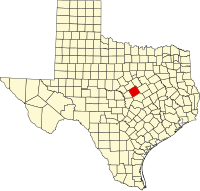 | |
| Towns | ||
| CDPs | ||
| Other communities | ||
| Footnotes | ‡This populated place also has portions in an adjacent county or counties | |