Draft:Structural geology
"Structural Geology [as a science is] a unified and integrated approach to the description and interpretation of deformation in the earth's crust, ranging from the microscopic scale, through mesoscopic structures, and up to the largest scale plate tectonic and orogenic structures."[1]
Tephra formations
[edit | edit source]"A massive eruption early in Mars’s history created a rocky outcrop [in the image on the right] that will greet NASA lander in 2021."[2]
"A sprawling rock formation that is scattered across a vast tract of Mars — including the crater where a rover is expected to touch down in 2021 — turns out to be the remnants of ash from an ancient eruption."[2]
"The formation is rich in the mineral olivine."[2]
Scientists "mapped the formation using data from several spacecraft, and calculated its thickness."[2]
"Examining the formation from this 3D perspective, the scientists concluded that the rock layer probably formed from volcanic ash that wafted across the landscape and then settled and hardened into rock. The formation likely took shape between about 3.96 billion and 3.6 billion years ago, during a time when scientists have proposed that explosive eruptions were more common on Mars."[2]
"NASA plans to launch its Mars 2020 rover next year and land it at Jerezo Crater, where the vehicle will be able to visit these rocks."[2]
"The origins of olivine-rich rocks on Mars remain only partially constrained, with hypothesized deposition as lava flows, impact products, aeolian sand, and pyroclastic materials. These rock units’ uncertain origins obscure their genetic relationships with each other and the contexts of their aqueous alteration. We synthesize geomorphic mapping and geomorphic and stratigraphic measurements with previous spectroscopic analyses to constrain the origin of the circum–Isidis Planitia olivine-rich unit, one of Mars’s most widespread and mineralogically diverse olivine-rich rocks. We find that the unit most likely formed as an ash-fall deposit, with a probable origin related to volcanism in the greater Syrtis Major–Isidis Planitia region."[3]
Theoretical structural geology
[edit | edit source]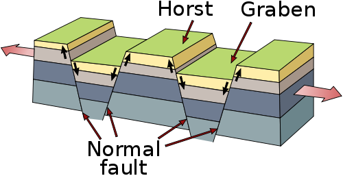
Lateral tension on rigid rock strata may produce a horst and graben structure.
Def. an "area of sea around a land mass where the depth gradually increases before it plunges into the ocean deeps"[4] is called a continental shelf.
Def. each "of the main continuous land-masses on the earth's surface, now generally regarded as seven in number, including their related islands, continental shelves etc."[5] is called a continent.
Columbia
[edit | edit source]
Gondwana
[edit | edit source]


Extent of the Karoo (olive-green) and Little Karoo (bright green) are in South Africa, with the names of surrounding areas in blue. The thick interrupted line indicates the course of the Great Escarpment which delimits the Central South African Plateau. To the immediate south and south-west the solid lines trace the parallel ranges of the Cape Fold Belt.[6]
In geological terms, the Karoo Supergroup refers to an extensive and geologically recent (180–310 million years old) sequence of sedimentary and igneous rocks,[7] which is flanked to the south by the Cape Fold Belt Mountains, and to the north by the more ancient Ventersdorp Lavas, the Transvaal Basin consisting of the Transvaal Supergroup and Waterberg Supergroup.[8] It covers two-thirds of South Africa and extends in places to 8000 m below the land surface, constituting an immense volume of rocks which was formed, geologically speaking, in a short period of time.[9][10]
Although almost the whole of the Great Karoo is situated on Karoo Supergroup rocks, the geological Karoo rocks extend over a very much larger area, both within South Africa and Lesotho, but also beyond its borders and onto other continents that formed part of Gondwana.[11][8][7]
The Karoo Supergroup was formed in vast inland basin starting 320 million years ago, at a time when the part of Gondwana which would eventually become Africa lay over the South Pole.[12][13] Icebergs that had calved off the glaciers and ice sheets to the north deposited a 1-km-thick layer of mud containing glacial erratics (dropstones) of varying origins and sizes into this basin. This became the Dwyka Group consisting primarily of tillite, the lowermost layer of the Karoo Supergroup.[7] As Gondwana drifted northwards, the basin turned into an inland sea with extensive swampy deltas along its northern shores. The peat in these swamps eventually turned into large deposits of coal which are mined in KwaZulu-Natal and on the Highveld. This 3-km-thick layer is known as the Ecca Group, which is overlain by the 5.6-km-thick Beaufort Group, laid down on a vast plain with Mississippi-like rivers depositing mud from an immense range of mountains to the south.[7] Ancient reptiles and amphibians prospered in the wet forests, and their remains have made the Karoo famous amongst palaeontologists. The first of these Karoo fossils was discovered in 1838 by Scots-born Andrew Geddes Bain at a road cutting near Fort Beaufort. He sent his specimens to the British Museum, where fellow Scotsman Robert Broom recognised the Karoo fossils' mammal-like characteristics in 1897.[14]
After the Beaufort period, Southern Africa (still part of Gondwana) became an arid sand desert with only ephemeral rivers and pans. These sands consolidated to form the Stormberg Group, the remnants of which are found only in the immediate vicinity of Lesotho. Several dinosaur nests, containing eggs, some with dinosaur fetal skeletons in them, have been found in these rocks, near what had once been a swampy pan.[15][16][17]
Finally, about 180 million years ago, volcanic activity took place on a titanic scale, which brought an end to a flourishing reptile evolution.[14]
"The end-Permian mass extinction is considered to be the most devastating biotic event in the history of life on Earth – it caused dramatic losses in global biodiversity, both in water and on land. About 90% of marine and 70% of terrestrial (land) species went extinct. This event may have been responsible for opening up niche spaces that ushered in the age of the dinosaurs. We know that the end-Permian in the marine realm happened about 251.9 million years ago – but the age and duration of the extinction on land, and whether it coincided with the marine extinctions, is one of the most hotly debated topics in palaeontology."[18]
"The South African Karoo Basin preserves the most complete sequence of the end-Permian extinction on land."[18]
When "the end-Permian mass extinction happened [...] is a maximum of 251.7 million years ago, with an error margin of about 300 000 years either way; geologically speaking this is quite short and still falls within the 251.9 marine date. This suggests the land extinction event happened at the same time as the marine extinction event."[18]
"The Karoo Basin, which includes about two-thirds of South Africa and parts of Lesotho, is the best region in the world for studying the end-Permian extinction on land. This is because of its rich fossil record and relatively complete sedimentological sequence."[18]
"Zircons are crystals found in volcanic ash and their radioisotopes – variants of different chemical elements – can be used to date the sediments in which they are found. Zircons from an ash bed provide the most accurate dates, but detrital zircons, which have been redeposited in the sediments, can also be used when a pristine ash bed is lacking."[18]
"The end-Permian mass extinction in the South African Karoo Basin correlated with the marine extinction at Meishan, China. [See the last image down on the right.] Radiometric dates: 251.902 ± 0.3 Ma, marine realm; 251.7 ± 0.3 Ma, terrestrial realm."[18]
"We collected fossils from the site to pinpoint the palaeontologically-defined extinction. We also studied the sediments, which allowed us to see how and when the climate changed during the extinction. This also helped us to pinpoint the event."[18]
"We then collected carbonate nodules (lumps of rock containing carbonate) from paleosols at the site – these are ancient soils. Analysing the isotopes from these palaeosols showed us they were similar to palaeosols found at other terrestrial and marine sites dating back to the Permian and Triassic periods. The Triassic Period immediately followed the Permian Period."[18]
"All of our analysis suggests that there was a mass extinction event at the time of the end-Permian, on land – and more importantly that it happened at the same time as the marine end-Permian extinction."[18]
"Our findings have global ramifications. They do not support previous arguments that propose the end-Permian extinction occurred later on land compared to the sea. Instead, they suggest these events happened at the same time."[18]
Greater Adria
[edit | edit source]The analysis represents "a huge amount of work. Although the tectonic history of the landmass has been generally known for a few decades. The amount of detail in the team’s systematic time-lapse reconstruction is unprecedented."[19]
"The only visible remnants of the continent—known as Greater Adria—are limestones and other rocks found in the mountain ranges of southern Europe. [These] rocks started out as marine sediments and were later scraped off the landmass’s surface and lifted up through the collision of tectonic plates. Yet the size, shape, and history of the original landmass—much of which lay beneath shallow tropical seas for millions of years—have been tough to reconstruct."[20]
"Greater Adria had a violent, complicated history. It became a separate entity when it broke away from the southern supercontinent of Gondwana (which comprised what is today Africa, South America, Australia, Antarctica, the Indian subcontinent, and the Arabian Peninsula) about 240 million years ago and started to move northward. About 140 million years ago, it was a Greenland-size landmass, largely submerged in a tropical sea, where sediments collected and slowly turned into rock. Then, as it collided with what is now Europe between 100 million and 120 million years ago, it shattered into pieces and was shoved beneath that continent. Only a fraction of Greater Adria’s rocks, scraped off in the collision, remained on Earth’s surface."[21]
"Another complication is that Greater Adria’s rocks are dispersed across more than 30 countries, in a swath from Spain to Iran. So, like the rocks themselves, data have been scattered and thus are difficult to collect. And finally, until the past decade or so geologists haven’t had the sophisticated software needed to perform such byzantine reconstructions. The Mediterranean region is quite simply a geological mess. Everything is curved, broken, and stacked."[21]
"Rather than simply moving north with no change in its orientation, Greater Adria spun counterclockwise as it jostled and scraped past other tectonic plates. Although the tectonic collision happened at speeds of no more than 3 to 4 centimeters per year, the inexorable smash-up shattered the 100-kilometer-thick bit of crust and sent most of it deep within Earth’s mantle."[21]
"Portions of Greater Adria now lie as much as 1500 kilometers below our planet’s surface."[20]
Laurentia
[edit | edit source]
Pangaea
[edit | edit source]
Pannotia
[edit | edit source]
Rodinia
[edit | edit source]Red dots on Rodinia indicate 1.3–1.5 Ga Anorogenic magmatism (A-type) granites.[22]
Faults
[edit | edit source]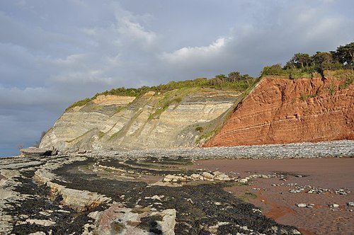

Def. a "fracture in a rock formation causing a discontinuity"[23] is called a fault.
"Possibly the most obvious fault line in Britain. The red rock with reduction horizons is Triassic Merica mudstone (MMS), to the left is Jurassic interbedded marls and muds (with evapourites like gypsum). You can tell this is a normal fault because the Jurassic strata is younger than the MMS. This means the Jurassic strata has slid downwards to sit beside the MMS. Also near the fault in the MMS the lighter reduction horizons are dipping downwards probably due to marginal drag. The line of the fault runs along the beach, shown by the rock/sand divide."[24]
Active faults
[edit | edit source]Def. a "fault that is likely to have another earthquake sometime in the future"[25] is called an active fault.
"Faults are commonly considered to be active if they have moved one or more times in the last 10,000 years."[25]
Thrust faults
[edit | edit source]"When Brúarjökull surged, large ice-marginal moraines which can be traced over many kilometers, were produced in front of the glacier. Todtmann (1952, 1955) identified two types of ice-marginal moraine; ‘stauchendmoräne’ and ‘blockendmoräne’ which are equivalent to push and probably dump moraines in modern terminology. Push moraines are the result of proglacial thrusting [as in the image at the top of the page] and folding of material, whereas, dump moraine might have resulted from material avalanching down a steep ice-front (Krüger et al., 2003a), although the specific processes at Brúarjökull are unknown."[26]
The second image on the right shows Late Weichselian proglacial deformation. A large thrust fault has resulted from glacial movement at Melabakkar, Iceland.
Blind thrust faults
[edit | edit source]Def. a "thrust fault that does not rupture all the way up to the surface so there is no evidence of it on the ground"[27] is called a blind thrust fault.
"It is "buried" under the uppermost layers of rock in the crust."[27]
Locked faults
[edit | edit source]Def. "a fault that is not slipping because frictional resistance on the fault is greater than the shear stress across the fault"[28] is called a locked fault.
Transform faults
[edit | edit source]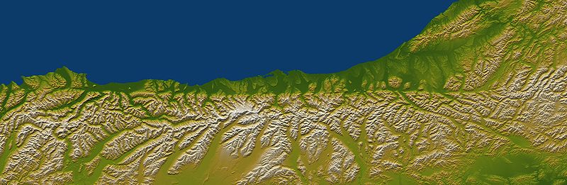
Def. "a special variety of strike-slip fault that accommodates relative horizontal slip between other tectonic elements, such as oceanic crustal plates"[29] is called a transform fault.
"The Alpine fault runs parallel to, and just inland of, much of the west coast of New Zealand's South Island. This view was created from the near-global digital elevation model produced by the Shuttle Radar Topography Mission (SRTM) and is almost 500 kilometers (just over 300 miles) wide. Northwest is toward the top. The fault is extremely distinct in the topographic pattern, nearly slicing this scene in half lengthwise."[30]
"In a regional context, the Alpine fault is part of a system of faults that connects a west dipping subduction zone to the northeast with an east dipping subduction zone to the southwest, both of which occur along the juncture of the Indo-Australian and Pacific tectonic plates. Thus, the fault itself constitutes the major surface manifestation of the plate boundary here. Offsets of streams and ridges evident in the field, and in this view of SRTM data, indicate right-lateral fault motion. But convergence also occurs across the fault, and this causes the continued uplift of the Southern Alps, New Zealand's largest mountain range, along the southeast side of the fault."[30]
"Two visualization methods were combined to produce this image: shading and color coding of topographic height. The shade image was derived by computing topographic slope in the northwest-southeast (image top to bottom) direction, so that northwest slopes appear bright and southeast slopes appear dark. Color coding is directly related to topographic height, with green at the lower elevations, rising through yellow and tan, to white at the highest elevations."[30]
"Elevation data used in this image were acquired by the Shuttle Radar Topography Mission aboard the Space Shuttle Endeavour, launched on Feb. 11, 2000. SRTM used the same radar instrument that comprised the Spaceborne Imaging Radar-C/X-Band Synthetic Aperture Radar (SIR-C/X-SAR) that flew twice on the Space Shuttle Endeavour in 1994. SRTM was designed to collect 3-D measurements of the Earth's surface. To collect the 3-D data, engineers added a 60-meter (approximately 200-foot) mast, installed additional C-band and X-band antennas, and improved tracking and navigation devices."[30]
The Alpine fault is "495 kilometers (307 miles) by 162 kilometers (100 miles). Location: 43.2 degrees South latitude, 170.5 degrees East longitude. Orientation: Northwest toward the top".[30]
Strike-slip faults
[edit | edit source]
Def. a "fault where two blocks move horizontally in opposite directions along the fault line"[31] is called a strike-slip fault.
The Piqiang Fault (China) is "a northwest trending strike-slip fault that runs roughly perpendicular to the thrust faults for more than 70 kilometers (40 miles). The colored sedimentary rock layers are offset by about 3 kilometers (2 miles) in this area."[32]
"The reddish, greenish and brownish bands are continental Devonian sandstones, Silurian deeper marine sediments and Cambro-Ordovician limestones, respectively. They form one of several parallel ridges (up to 1200 m high) which all are composed of the same stack of rocks and belong to the Keping Shan thrust belt immediately south of the Southern Tien Shan Mountains."[33]
Dextral faults
[edit | edit source]
Def. "a strike-slip fault that shows right lateral movement [movement of the right-hand block toward the observer standing across the fault plane]"[34] is called a dextral fault.
The strike-slip fault in the image on the right is a dextral fault.
Sinistral faults
[edit | edit source]
Def. "a strike-slip fault that shows left lateral movement [movement of the left-hand block toward the observer standing across the fault plane]"[35] is called a sinistral fault.
Alternating layers of mudstone and sandstone of the Sidi Bettache Basin of Carboniferous age, cut by a normal fault in Seppap Gorge near Sidi Bettache, Morocco, shown in the image on the right. The outcrop is about 5 metres high.
Surface faults
[edit | edit source]On the right is an example of a surface fault. Here, the surface above the Hector Mine ruptured after 1999 earthquake in southern California.
Deformed strata
[edit | edit source]In the image on the right are glaciotectonically "rolled up" soils from the Brúarjökull 1890 end moraine.
The second image on the right shows additional glaciotectonic deformations from the Brúarjökull 1890 end moraine.
On the left are heavily deformed marine sediments from the Svalbard Kongsoya near Bogen.
The second image on the left shows folded strata dated to the Carboniferous and Permian in Ingeborgfjellet, Van Mienfjorden, Spitsbergen.
Volcanic arcs
[edit | edit source]Def. a "chain of volcanoes that sometimes forms on the land when an oceanic plate collides with a continental plate and then slides down underneath it (subduction)"[36] is called a volcanic arc.
Accretionary wedges
[edit | edit source]
Def. sediments, "the top layer of material on a tectonic plate, that accumulate and deform where oceanic and continental plates collide"[37] are called an accretionary wedge.
"These sediments are scraped off the top of the downgoing oceanic crustal plate and are appended to the edge of the continental plate."[37]
Def. an "accumulation of surface sediment formed between a subducting oceanic crustal plate and a continental tectonic plate, as it is scraped from off the top of the oceanic crustal plate"[38] is called an accretionary wedge.
Folded strata
[edit | edit source]On the right are extensively folded strata from the Kringilsa section in the forefield of Brúarjökull. These folded strata were produced by a glacial surge.
Abrasion platforms
[edit | edit source]
Def. a "sloping or nearly flat bedrock surface extending out from the foot of a marine cliff under shallow water of a breaker (wave) zone, that was created by marine abrasion"[39] is called an abrasion platform.
The rock surface in the image on the right at the foot of the Heads of Ayr cliffs is the result of wave abrasion on the headland.
Abyssoliths
[edit | edit source]
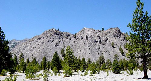
Def. a "mass of igneous rock deep in the crust with no known bottom; a large batholith"[40] is called an abyssolith.
"According to systematic deduction from a host of facts the feeders of volcanoes appear to be abyssoliths, molten masses injected upward into the Earth's crust from a vitreous, gas-charged substratum of basalt."[41]
The Sierra Nevada Batholith of which the image on the right is a part has no known bottom.
Allochthons
[edit | edit source]Def. a "geological formation not formed in the region where found and moved to its present location by tectonic forces"[42] is called an allochthon.
Anticlines
[edit | edit source]
Def. a "fold with strata sloping downwards on each side"[43] is called an anticline.
Anticlinoriums
[edit | edit source]
Def. a "series of parallel anticlinal folds on a regional-scale anticline"[44] is called an anticlinorium.
On the right is a map of an anticlinorium near Nelson, Australia. The observations made by the writers seem to show that the rocks of the Maitai Seiies in the Dun Mountain Subdivision have been folded into an anticlinorium, mainly occupied now by the intrusions of the Mineral Belt, and into a synclinorium lying to the west of the anticlinorium.
Aulacogens
[edit | edit source]Def. a "tectonic trough on a craton that is formed as the failed arm of a triple-rift junction"[45] is called an aulacogen.
Autochthons
[edit | edit source]Def. a rock formation native to the place where found is called an autochthon.
Autogeosynclines
[edit | edit source]Def. a "parageosyncline that subsides as an elliptical basin or trough nearly without associated highlands"[46] is called an autogeosyncline.
Backarcs
[edit | edit source]Def. the "landward region of a volcanic chain, opposite the subduction zone"[47] is called a backarc.
Batholiths
[edit | edit source]Def. a "large irregular mass of intrusive igneous rock that has melted or forced itself into surrounding strata"[48] is called a batholith.
Diapirs
[edit | edit source]
Def. an "intrusion of a ductile rock into an overburden"[49] is called a diapir.
The geological cross section through the Northwestern Basin of Germany (Ostfriesland-Nordheide) above shows the record and deposits since the Permian (about 250 Ma). Salt domes of the Zechstein have penetrated the overburden layers and intruded close to the surface.
Dikes
[edit | edit source]Def. a "body of once molten igneous rock that was injected into older rocks in a manner that crosses bedding planes"[50] is called a dike.
Diatremes
[edit | edit source]Def. a "cone-shaped volcanic vent produced by the explosion of gas-filled magma"[51] is called a diatreme.
Eugeosynclines
[edit | edit source]Def. a "narrow rapidly subsiding geosyncline usually with volcanic materials mingled with clastic sediments"[52] is called a eugeosyncline.
Geanticlines
[edit | edit source]Def. a "large-scale anticline; a large upward lift in the earth's surface"[53] is called a geanticline.
Geologic joints
[edit | edit source]Def. a "fracture in rock in which (unlike a fault) the strata do not move relative to each other"[54] is called a geologic joint.
Geosynclines
[edit | edit source]Def. a "large, linear depression in the Earth's crust in which sediment accumulates"[55] is called a geosyncline.
Grabens
[edit | edit source]Def. an "elongated block of the Earth's crust that has dropped relative to the surrounding blocks"[56] is called a graben.
Horsts
[edit | edit source]Def. "an area of the earth's surface which is raised relative to surrounding land"[57] is called a horst.
Hydrolaccoliths
[edit | edit source]Def. a "frost mound that has a core of ice and resembles a laccolith in cross-section"[58] is called a hydrolaccolith.
Intrusions
[edit | edit source]
Def. magma "forced into other rock formations; the rock formed when such magma solidifies"[59] is called an intrusion.
Def. "a large body of igneous rock within which distinct stratification continues over many miles"[60] is called a layered intrusion.
Def. the "metamorphism of plutonic rock into magma in the lower levels of the crust"[61] is called anatexis.
Def. an "intrusion of the continental crust subject to anatexis"[62] is called a leucogranite.
Isoclines
[edit | edit source]Def. a "tightly folded syncline or anticline in which the two sides are almost parallel"[63] is called an isocline.
Laccoliths
[edit | edit source]Def. "a mass of igneous or volcanic rock found within strata which forces the overlaying strata upwards and forms domes"[64] is called a laccolith.
Lava domes
[edit | edit source]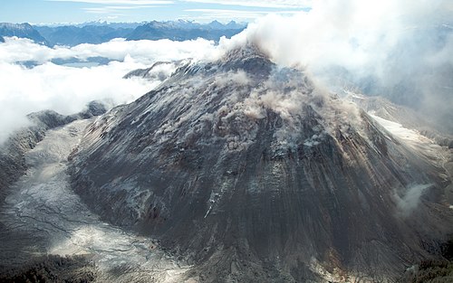


Def. a roughly circular mound-shaped bulge that builds up from the slow eruption of viscous felsic lava from a volcano is called a lava dome.
Lava domes are rarely seen in shield volcanos, but are common in stratovolcanos because the latter have more silicic magmas.
Mount St. Helens has been building a new lava dome since the May, 1980 eruption.
"Streams of molten rock that ooze from gaps or vents in the Earth’s surface are called lava flows. Though generally slow-moving, these rivers of rock pose a hazard to everything in their paths. They can bury or burn homes and roads, ruin farmland for generations, and transform glaciers into muddy landslides (lahars)."[65]
"Lava flows can take many shapes and move at very different rates depending on the viscosity of the magma, the slope of the land, and the rate of an eruption. Some of the speediest flows travel 60 kilometers (40 miles) per hour; the slowest creep along at less than 1 kilometer (0.6 miles) per hour. They can sometimes even flow for more than a year after an eruption has ended."[65]
"Viscous (or sticky), non-explosive flows produce distinctive landforms known as lava domes. These circular mounds form as lava slowly oozes from a vent and piles up on itself over time. Lava domes tend to have steep, cliff-like fronts at their leading edge and wrinkle-like pressure ridges on their surfaces."[65]
"The Chao dacite is a type of lava dome known as a coulée. These elongated flow structures form when highly-viscous lavas flow onto steep surfaces. On May 14, 2013, the Operational Land Imager (OLI) on NASA’s Landsat 8 satellite acquired the image above, which highlights some of the distinctive features of a coulée."[65]
"The Chao dacite sits between two volcanoes in northern Chile: the older and partially-eroded Cerro del Leon and the younger Paniri. The dome itself is a giant tongue of rock that extends southwest from the vent. Curved pressure ridges known as ogives dominate the surface of the 14 kilometer (9 mile) dome."[65]
"Volcanologists think the Chao dacite dome formed over a period of about 100 to 150 years. A pyroclastic flow during the Chao I phase left light-brown deposits of tephra and pumice at the leading edge of the flow. Pyroclastic flows are avalanche-like events that bring mixtures of hot gas and semi-sold rocks surging down the flanks of volcanoes at speeds as fast as 100 kilometers (60 miles) per hour."[65]
"This period was followed by the Chao II phase, when 22.5 cubic kilometers (5.4 cubic miles) of lava erupted. This flow has 400-meter tall (1,312 feet) fronts that stand out with their dark shadows on the southwest end. The final, Chao III phase added another 3.5 cubic kilometers (0.8 cubic miles) of denser lava with a lower viscosity. This type of lava is less likely to form pressure ridges, so surfaces in this part of the flow are comparatively smooth."[65]
"It’s not clear why the Chao dacite erupted as a flow and formed a dome rather than erupting explosively. However, some researchers have noted that there are a number of other domes in the area (such as Chillahuita), suggesting that the domes may be the leading edge of a broader magmatic system that erupted along pre-existing faults. Though much larger, a series of lava domes along the eastern side of California’s Sierra Nevada range—the Mono-Inyo chain—offers a possible analog for what might be happening in this part of Chile."[65]
Lopoliths
[edit | edit source]Def. "a mass of volcanic or igneous rock found within strata which has spilled downward into underlaying strata and forms depressed regions"[66] is called a lopolith.
Miogeoclines
[edit | edit source]Def. an "area of sedimentation that occurs along the passive margin of a continent"[67] is called a miogeocline.
Orthogeosynclines
[edit | edit source]Def. a "linear geosynclinal belt lying between continental and oceanic cratons, and having internal volcanic belts (eugeosynclinal) and external nonvolcanic belts (miogeosynclinal)"[68] is called an orthogeosyncline.
Overfolds
[edit | edit source]Def. a "fold whereby the strata are forced through an angle of more than 90 degrees, so that younger strata lie below older ones"[69] is called an overfold.
Overshifts
[edit | edit source]Def. an "overhang caused by seismic shift"[70] is called an overshift.
Overthrusts
[edit | edit source]Def. a "form of thrust fault from beneath a hanging wall of rock"[71] is called an overthrust.
Palaeoshorelines
[edit | edit source]Def. the "shoreline as it was in the geologic past"[72] is called a palaeoshoreline.
Palaeosubductions
[edit | edit source]Def. a "subduction that occurred in the geologic past"[73] is called a palaeosubduction.
Parageosynclines
[edit | edit source]Def. a "geosyncline within or adjacent to a craton and usually less elongated, shallower, and less persistent than an orthogeosyncline"[74] is called a parageosyncline.
Rifts
[edit | edit source]"An iceberg [in the image on the right] expected to be one of the 10 largest ever recorded is ready to break away from Antarctica."[75]
"A long-running rift in the Larsen C ice shelf grew suddenly in December and now just 20 km of ice is keeping the 5,000 sq km piece from floating away."[76]
"Larsen C is about 350m thick and floats on the seas at the edge of West Antarctica, holding back the flow of glaciers that feed into it."[76]
"Researchers have been tracking the rift in Larsen C for many years, watching it with some trepidation after the collapse of Larsen A ice shelf in 1995 and the sudden break-up of the Larsen B shelf in 2002."[76]
In "December [2016] the speed of the rift went into overdrive, growing by a further 18 km in just a couple of weeks."[76]
"The rift is about 100 m wide but is estimated to be half a kilometre deep."[76]
This "is a geographical and not a climate event. The rift has been present for decades, but it has punched through at this particular time."[75]
"The collapse of the Larsen B ice shelf which occurred in 2002 followed on from a large rift calving event."[76]
"We would expect in the ensuing months to years further calving events [from Larsen C], and maybe an eventual collapse - but it's a very hard thing to predict, and our models say it will be less stable; not that it will immediately collapse or anything like that."[75]
"Even the sea level contribution of this area is not on anybody's radar; it's just a big geographical event that will change the landscape there."[75]
"Geologists working in the remote Afar region of Ethiopia say the ocean will eventually split the African continent in two, though it will take about 10 million years."[77]
"In 2005, a 60 km long stretch of the earth [in the image second down on the right] opened up to a width of eight metres over a period of just ten days."[77]
"Hot, molten rock from deep within the Earth is trickling to the surface and creating the split."[77]
"Underground eruptions are still continuing and, ultimately, the horn of Africa will fall away and a new ocean will form."[77]
Parts "of the [Afar] region are below sea level and the ocean is only cut off by about a 20-metre block of land in Eritrea."[78]
"Eventually this will drift apart. The sea will flood in and will start to create this new ocean. It will pull apart, sink down deeper and deeper and eventually... parts of southern Ethiopia, Somalia will drift off, create a new island, and we'll have a smaller Africa and a very big island that floats out into the Indian Ocean."[78]
"The 60 km-long rift was initially sparked by an earthquake in September."[79]
"It betrays events deep beneath the ground, where some of the tectonic plates that form Africa are gradually moving apart from the Arabian plate, causing the crust to stretch and thin."[79]
"As rifts appear [shown in the third image down on the right], molten rock bubbles up from beneath the surface, hardening to form a new strip of ocean floor."[79]
"We think if these processes continue, a new ocean will eventually form. It will connect to the Red Sea and the ocean will flow in."[80]
"We've been able to work up all the satellite data and get a very precise map. It's the biggest rifting episode at least since the 1970s and possibly in hundreds of years. It's the first time we've been able to use satellite images to investigate the fundamental processes behind rifting."[80]
"It's the first large event we have seen like this in a rift zone since the advent of some of the space-based techniques we're now using. These techniques give us a resolution and a detail to see what's really going on and how the Earth processes work."[81]
"2.5 cubic km (0.6 cubic mile) of magma has flowed up through the crack in the Earth's crust."[79]
An "8 m rift develop in the ground in just three weeks in the Afar desert region last September."[82]
"It began with a large earthquake on the 14th of the month and continued with a swarm of moderate tremors."[82]
"About a week into the sequence, there was a volcanic eruption. A lot of ash was thrown up in the air, and a lot of cracks appeared in the ground; some of which were more than a metre wide [shown in the fourth image down on the right]. Using satellite techniques we can see ground deformation, and about a month after the sequence, we could see a 60 km long section had opened up, and it opened up about 8 m in its central part. It appears that we've seen the birth of an ocean basin."[83]
A more regional map is shown in the fifth image down on the right which geographically locate the Afar desert.
Hypotheses
[edit | edit source]- All or nearly all folded rocks are produced by glacial surges scraping sediment off bedrock while the sediment is still water soaked.
See also
[edit | edit source]- Astrogeology (52 kB) (11 August 2019)
- Astrognosy (43 kB) (13 August 2019)
- Geology
- Geomorphology (71 kB) (13 August 2019)
- Geophysics (80 kB) (12 August 2019)
- Geoseismology (36 kB) (25 June 2019)
- Mediterranean continental shelves
- North east American continental shelves
- North Sea continental shelves (104 kB) (25 April 2019)
- North west African continental shelves
- Oceanography (25 kB) (8 August 2019)
- South east African continental shelves (13 kB) (22 May 2019)
- South east Asian continental shelves
- Structural geology (60 kB) (9 September 2019)
- West European continental shelves
References
[edit | edit source]- ↑ Robert J. Twiss (12 April 1992). Structural geology. Macmillan. pp. 532. ISBN 0716722526. http://books.google.com/books?hl=en&lr=lang_en&id=14fn03iJ2r8C&oi=fnd&pg=PR9&ots=Ji9tweQzRK&sig=vOzRLa0ZfHg71w92vWp5UGjkV5o. Retrieved 2014-11-25.
- ↑ 2.0 2.1 2.2 2.3 2.4 2.5 Christopher Kremer (29 May 2019). "Mysterious Martian formation traced to volcanic explosion". Nature. Retrieved 1 June 2019.
- ↑ Christopher H. Kremer, John F. Mustard, and Michael S. Bramble (May 22, 2019). "A widespread olivine-rich ash deposit on Mars". Geology 47 (7): 570813. doi:10.1130/G45563.1. https://pubs.geoscienceworld.org/gsa/geology/article-abstract/570813/a-widespread-olivine-rich-ash-deposit-on-mars. Retrieved 1 June 2019.
- ↑ SemperBlotto (9 September 2006). "continental shelf". San Francisco, California: Wikimedia Foundation, Inc. Retrieved 2015-05-17.
{{cite web}}:|author=has generic name (help) - ↑ Widsith (21 April 2010). "continent". San Francisco, California: Wikimedia Foundation, Inc. Retrieved 9 September 2019.
{{cite web}}:|author=has generic name (help) - ↑ Atlas of Southern Africa. (1984). p. 13, 98-106, 114-119. Reader’s Digest Association, Cape Town
- ↑ 7.0 7.1 7.2 7.3 McCarthy, T., Rubridge, B. (2005). The Story of Earth and Life. p. 89-90, 102-107, 134-136,159-161, 195-211, 248-254. Struik Publishers, Cape Town
- ↑ 8.0 8.1 Geological Map of South Africa, Lesotho and Swaziland. (1970). Council for Geoscience, Geological Survey of South Africa.
- ↑ Bulpin, Thomas Victor (1985). "7. The lost world of the dinosaurs: The Karoo sequence". Scenic Wonders of Southern Africa. Books of Africa. pp. 199–221. ISBN 0-949956-26-0.
- ↑ Reid, R., ed (2005). "7. The lost world of the dinosaurs: The Karoo sequence". The Story of Earth & Life. Struik Publishers. pp. 199–221. ISBN 1-77007-148-2.
- ↑ Reader’s Digest Illustrated Guide to Southern Africa. (5th Ed. 1993). pp. 78-89. Reader’s Digest Association of South Africa Pty. Ltd., Cape Town.
- ↑ Norman, N., Whitfield, G. (2006) Geological Journeys. p. 206-223, 243-247, 252-273, 300-311. Struik Publishers, Cape Town.
- ↑ Jackson, A.A., Stone, P. (2008). Bedrock Geology UK South. p. 6-7. Keyworth, Nottingham: British Geological Survey.
- ↑ 14.0 14.1 Walton, Christopher, ed (1984). "Anatomy of South Africa: 200 million years ago". Atlas of Southern Africa. The Reader's Digest Association South Africa. pp. 14–15. ISBN 0-947-008-02-0.
- ↑ Knight, Will (28 July 2005). "Early dinosaurs crawled before they ran". New Scientist. Retrieved 23 June 2009.
- ↑ Footprint. "Rhebok Hiking Trail" (PDF). Retrieved 13 August 2006.
- ↑ Weishampel, David B; et al (2004). "Dinosaur distribution (Early Jurassic, Africa)." In: Weishampel, David B.; Dodson, Peter; and Osmólska, Halszka (eds.): The Dinosauria, 2nd, Berkeley: University of California Press. Pp. 535–536. ISBN 0-520-24209-2.
- ↑ 18.00 18.01 18.02 18.03 18.04 18.05 18.06 18.07 18.08 18.09 Jennifer Botha (23 February 2020). "New Research Might Explain How the Dinosaurs Were Born". South Africa: The National Interest. Retrieved 23 February 2020.
- ↑ Laurent Jolivet (6 September 2019). "Geologists uncover history of lost continent buried beneath Europe". Science Magazine. Retrieved 9 September 2019.
- ↑ 20.0 20.1 Sid Perkins (6 September 2019). "Geologists uncover history of lost continent buried beneath Europe". Science Magazine. Retrieved 9 September 2019.
- ↑ 21.0 21.1 21.2 Douwe van Hinsbergen (6 September 2019). "Geologists uncover history of lost continent buried beneath Europe". Science Magazine. Retrieved 9 September 2019.
- ↑ "Research paper suggests East Antarctica and North America once linked". The Antarctic Sun. United States Antarctic Program. 26 August 2011. Retrieved 15 November 2012. Reconstruction originally published in Goodge et al. 2008, Fig 3A, p. 238; research paper mentioned is Loewy et al. 2011. See also: Rejcek 2008.
- ↑ fault. San Francisco, California: Wikimedia Foundation, Inc. 9 November 2014. https://en.wiktionary.org/wiki/fault. Retrieved 2014-11-26.
- ↑ Ashley Dace (2011). ST0343 : The Blue Anchor Fault. United Kingdom: Geograph.org. http://www.geograph.org.uk/photo/2455274. Retrieved 2014-11-29.
- ↑ 25.0 25.1 Kerry Sieh (July 18, 2012). Earthquake Glossary - active fault. USGS. http://earthquake.usgs.gov/learn/glossary/?term=active%20fault. Retrieved 2014-12-01.
- ↑ Kurt Kjær and Ólafur Ingólfsson (2005). "The Brúarjökull Project: Sedimentary environments of a surging glacier". Iceland: Landsvirkjun. Retrieved 2014-11-25.
- ↑ 27.0 27.1 Stephen Nelson (July 24, 2012). "Earthquake Glossary - blind thrust fault". Reston, Virginia USA: USGS. Retrieved 2014-12-02.
- ↑ Geological Survey of Canada (July 24, 2012). "Earthquake Glossary - locked fault". Reston, Virginia USA: USGS. Retrieved 2014-12-02.
- ↑ EGtransform (July 18, 2012). "Earthquake Glossary - transform fault". Reston, Virginia USA: USGS. Retrieved 2014-12-02.
- ↑ 30.0 30.1 30.2 30.3 30.4 NASA/JPL/NGA (6 January 2005). "PIA06661: Alpine Fault, New Zealand, SRTM Shaded Relief and Colored Height". Pasadena, California USA: NASA/JPL/NGA. Retrieved 2014-12-02.
- ↑ "strike-slip fault". San Francisco, California: Wikimedia Foundation, Inc. 19 June 2013. Retrieved 2015-02-10.
- ↑ Adam Voiland (16 January 2014). "Faults in Xinjiang". Washington, DC USA: NASA. Retrieved 2016-03-08.
- ↑ Bramfab (30 July 2013). "File:Piqiang Fault, China detail.jpg, In: Wikimedia Commons". San Francisco, California: Wikimedia Foundation, Inc. Retrieved 2016-03-08.
{{cite web}}:|author=has generic name (help) - ↑ "dextral fault, In: Wiktionary". San Francisco, California: Wikimedia Foundation, Inc. 19 June 2013. Retrieved 2015-02-10.
- ↑ "sinistral fault, In: Wiktionary". San Francisco, California: Wikimedia Foundation, Inc. 19 June 2013. Retrieved 2015-02-10.
- ↑ Lynn Fichter (July 24, 2012). "Earthquake Glossary - arc". Reston, Virginia USA: USGS. Retrieved 2014-12-02.
- ↑ 37.0 37.1 USGS (July 24, 2012). "Earthquake Glossary - accretionary wedge". Reston, Virginia USA: USGS. Retrieved 2014-12-02.
- ↑ "accretionary wedge, In: Wiktionary". San Francisco, California: Wikimedia Foundation, Inc. 16 June 2013. Retrieved 2015-02-09.
- ↑ "abrasion platform, In: Wiktionary". San Francisco, California: Wikimedia Foundation, Inc. 12 January 2015. Retrieved 2015-02-09.
- ↑ "abyssolith, In: Wiktionary". San Francisco, California: Wikimedia Foundation, Inc. 23 May 2014. Retrieved 2015-02-09.
- ↑ Reginald A. Daly (August 1938). "The roots of volcanoes". Eos, Transactions American Geophysical Union 19 (1): 35-9. doi:10.1029/TR019i001p00035. http://onlinelibrary.wiley.com/doi/10.1029/TR019i001p00035/full. Retrieved 2016-03-08.
- ↑ "allochthon, In: Wiktionary". San Francisco, California: Wikimedia Foundation, Inc. 25 January 2015. Retrieved 2015-02-09.
- ↑ "anticline, In: Wiktionary". San Francisco, California: Wikimedia Foundation, Inc. 7 June 2014. Retrieved 2015-02-09.
- ↑ "anticlinorium, In: Wiktionary". San Francisco, California: Wikimedia Foundation, Inc. 19 September 2013. Retrieved 2015-02-09.
- ↑ "aulacogen, In: Wiktionary". San Francisco, California: Wikimedia Foundation, Inc. 29 March 2014. Retrieved 2015-02-09.
- ↑ "autogeosyncline, In: Wiktionary". San Francisco, California: Wikimedia Foundation, Inc. 4 January 2015. Retrieved 2015-02-09.
- ↑ "backarc, In: Wiktionary". San Francisco, California: Wikimedia Foundation, Inc. 16 June 2013. Retrieved 2015-02-10.
- ↑ "batholith, In: Wiktionary". San Francisco, California: Wikimedia Foundation, Inc. 15 December 2014. Retrieved 2015-02-09.
- ↑ "diapir, In: Wiktionary". San Francisco, California: Wikimedia Foundation, Inc. 16 December 2014. Retrieved 2015-02-10.
- ↑ "dike, In: Wiktionary". San Francisco, California: Wikimedia Foundation, Inc. 24 August 2014. Retrieved 2015-02-10.
- ↑ "diatreme, In: Wiktionary". San Francisco, California: Wikimedia Foundation, Inc. 19 June 2013. Retrieved 2015-02-10.
- ↑ "eugeosyncline, In: Wiktionary". San Francisco, California: Wikimedia Foundation, Inc. 4 January 2015. Retrieved 2015-02-11.
- ↑ "geanticline, In: Wiktionary". San Francisco, California: Wikimedia Foundation, Inc. 16 December 2014. Retrieved 2015-02-11.
- ↑ "geologic joint, In: Wiktionary". San Francisco, California: Wikimedia Foundation, Inc. 20 June 2013. Retrieved 2015-02-11.
- ↑ "geosyncline, In: Wiktionary". San Francisco, California: Wikimedia Foundation, Inc. 16 December 2014. Retrieved 2015-02-11.
- ↑ "graben, In: Wiktionary". San Francisco, California: Wikimedia Foundation, Inc. 2 January 2015. Retrieved 2015-02-11.
- ↑ "horst, In: Wiktionary". San Francisco, California: Wikimedia Foundation, Inc. 24 May 2014. Retrieved 2015-02-11.
- ↑ "hydrolaccolith, In: Wiktionary". San Francisco, California: Wikimedia Foundation, Inc. 27 May 2014. Retrieved 2015-02-11.
- ↑ "intrusion, In: Wiktionary". San Francisco, California: Wikimedia Foundation, Inc. 16 December 2014. Retrieved 2015-02-15.
- ↑ "layered intrusion, In: Wiktionary". San Francisco, California: Wikimedia Foundation, Inc. 19 June 2013. Retrieved 2015-02-18.
- ↑ "anatexis, In: Wiktionary". San Francisco, California: Wikimedia Foundation, Inc. 16 June 2013. Retrieved 2015-02-19.
- ↑ "leucogranite, In: Wiktionary". San Francisco, California: Wikimedia Foundation, Inc. 19 June 2013. Retrieved 2015-02-19.
- ↑ "isocline, In: Wiktionary". San Francisco, California: Wikimedia Foundation, Inc. 16 December 2014. Retrieved 2015-02-16.
- ↑ "laccolith, In: Wiktionary". San Francisco, California: Wikimedia Foundation, Inc. 16 December 2014. Retrieved 2015-02-17.
- ↑ 65.0 65.1 65.2 65.3 65.4 65.5 65.6 65.7 Erik Klemetti and Adam Voiland (21 November 2013). The Shapes that Lavas Take, Part 1. Washington, DC USA: NASA. http://earthobservatory.nasa.gov/IOTD/view.php?id=82424. Retrieved 2015-02-18.
- ↑ "lopolith, In: Wiktionary". San Francisco, California: Wikimedia Foundation, Inc. 24 May 2014. Retrieved 2015-02-17.
- ↑ "miogeocline, In: Wiktionary". San Francisco, California: Wikimedia Foundation, Inc. 23 August 2011. Retrieved 2015-02-11.
- ↑ "orthogeosyncline, In: Wiktionary". San Francisco, California: Wikimedia Foundation, Inc. 4 January 2015. Retrieved 2015-02-11.
- ↑ Widsith (1 February 2012). "overfold, In: Wiktionary". San Francisco, California: Wikimedia Foundation, Inc. Retrieved 2017-01-12.
{{cite web}}:|author=has generic name (help) - ↑ Kiwima (21 June 2016). "overshift, In: Wiktionary". San Francisco, California: Wikimedia Foundation, Inc. Retrieved 2017-01-12.
{{cite web}}:|author=has generic name (help) - ↑ SemperBlotto (9 June 2007). "overthrust, In: Wiktionary". San Francisco, California: Wikimedia Foundation, Inc. Retrieved 2017-01-12.
{{cite web}}:|author=has generic name (help) - ↑ SemperBlotto (14 September 2009). "palaeoshoreline, In: Wiktionary". San Francisco, California: Wikimedia Foundation, Inc. Retrieved 2017-01-12.
{{cite web}}:|author=has generic name (help) - ↑ SemperBlotto (19 February 2009). "palaeosubduction". San Francisco, California: Wikimedia Foundation, Inc. Retrieved 2017-01-12.
{{cite web}}:|author=has generic name (help) - ↑ WikiWinters (4 January 2015). "parageosyncline, In: Wiktionary". San Francisco, California: Wikimedia Foundation, Inc. Retrieved 2017-01-12.
{{cite web}}:|author=has generic name (help) - ↑ 75.0 75.1 75.2 75.3 Adrian Luckman (6 January 2017). "Huge Antarctic iceberg poised to break away". London, England: BBC. Retrieved 2017-01-09.
- ↑ 76.0 76.1 76.2 76.3 76.4 76.5 Matt McGrath (6 January 2017). "Huge Antarctic iceberg poised to break away". London, England: BBC. Retrieved 2017-01-09.
- ↑ 77.0 77.1 77.2 77.3 Matt McGrath (25 June 2010). "Africa 'witnessing birth of a new ocean'". London, England: BBC News. Retrieved 2017-01-12.
- ↑ 78.0 78.1 James Hammond (25 June 2010). "Africa 'witnessing birth of a new ocean'". London, England: BBC News. Retrieved 2017-01-12.
- ↑ 79.0 79.1 79.2 79.3 Helen Briggs (19 July 2006). "Secrets of ocean birth laid bare". London, England: BBC News. Retrieved 2017-01-12.
- ↑ 80.0 80.1 Tim Wright (19 July 2006). "Secrets of ocean birth laid bare". London, England: BBC News. Retrieved 2017-01-12.
- ↑ Cynthia Ebinger (19 July 2006). "Secrets of ocean birth laid bare". London, England: BBC News. Retrieved 2017-01-12.
- ↑ 82.0 82.1 Roland Pease (8 December 2005). "Geologists witness 'ocean birth'". London, England: BBC News. Retrieved 2017-01-12.
- ↑ Cynthia Ebinger (8 December 2005). "Geologists witness 'ocean birth'". London, England: BBC News. Retrieved 2017-01-12.
Further reading
[edit | edit source]- Robert J. Twiss (12 April 1992). Structural geology. Macmillan. pp. 532. ISBN 0716722526. http://books.google.com/books?hl=en&lr=lang_en&id=14fn03iJ2r8C&oi=fnd&pg=PR9&ots=Ji9tweQzRK&sig=vOzRLa0ZfHg71w92vWp5UGjkV5o. Retrieved 2014-11-25.
External links
[edit | edit source]- Dictionary of Geology
- Earthquake Glossary
- Geography and geology images of Great Britain and Ireland
- Schlumberger Oilfield Glossary
- Google Map of Geology: Zoom in close on over 80 examples of structural geology terms.
Learn more about Structural geology |