Fitxategi:Daegu in South Korea 2023.svg

Bereizmen handikoa (SVG fitxategia, nominaldi 1.772 × 1.672 pixel, fitxategiaren tamaina: 445 KB)
Fitxategi hau Wikimedia Commonsekoa da. Hango deskribapen orriko informazioa behean duzu. |
Laburpena


|
This map has been made or improved in the German Kartenwerkstatt (Map Lab). You can propose maps to improve as well.
|
Lizentzia
Usage of this file with:

explanatory notes: Legally binding is only the full legalcode. For a free usage I recommend to respect the following licence conditions:
1. Provide my name as given above: NordNordWest,
2. a copy of, or the URI for, the applicable license: https://creativecommons.org/licenses/by-sa/3.0/de/legalcode,
3. the title of the work,
4. in the case of an adaptation, a credit identifying the use of the work in the adaptation.
This license and the rights granted hereunder will terminate automatically upon any breach by you of the terms of this license. Any of the above conditions can be waived if you get permission from the copyright holder. If you have questions or wish differing conditions, please contact me through nnwest or my discussion page t-online.de
- Askea zara:
- partekatzeko – lana kopiatzeko, banatzeko eta bidaltzeko
- birnahasteko – lana moldatzeko
- Ondorengo baldintzen pean:
- eskuduntza – Egiletza behar bezala aitortu behar duzu, lizentzia ikusteko esteka gehitu, eta ea aldaketak egin diren aipatu. Era egokian egin behar duzu hori guztia, baina inola ere ez egileak zure lana edo zure erabilera babesten duela irudikatuz.
- berdin partekatu – Lan honetan oinarrituta edo aldatuta berria eraikitzen baduzu, emaitza lana hau bezalako lizentzia batekin argitaratu behar duzu.

Fitxategiaren historia
Data/orduan klik egin fitxategiak orduan zuen itxura ikusteko.
| Data/Ordua | Iruditxoa | Neurriak | Erabiltzailea | Iruzkina | |
|---|---|---|---|---|---|
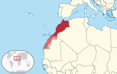
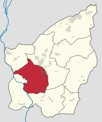
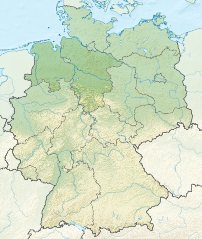
| oraingoa | 18:46, 5 uztaila 2023 | 1.772 × 1.672 (445 KB) | NordNordWest | == {{int:filedesc}} == {{Information |Description={{de|Lage von Daegu in {{wd|Südkorea}}}} {{en|Location of Daegu in {{w|South Korea}}}} |Source={{own based|South Korea adm location map.svg|by=NordNordWest}} |Date=2023-07-05 |Author={{U|NordNordWest}} |Permission= |other_versions={{SVG locator maps (location map scheme)}} }} {{Kartenwerkstatt}} == {{int:license-header}} == {{User:NordNordWest/LicenceMap}} Category:SVG locator maps of provinces in South Korea (location map scheme) |
Irudira dakarten loturak
Hurrengo orrialdeek dute fitxategi honetarako lotura:
Fitxategiaren erabilera orokorra
Hurrengo beste wikiek fitxategi hau darabilte:
- ar.wikipedia.org proiektuan duen erabilera
- ast.wikipedia.org proiektuan duen erabilera
- bcl.wikipedia.org proiektuan duen erabilera
- ca.wikipedia.org proiektuan duen erabilera
- de.wikipedia.org proiektuan duen erabilera
- el.wikipedia.org proiektuan duen erabilera
- en.wikipedia.org proiektuan duen erabilera
- eo.wikipedia.org proiektuan duen erabilera
- gl.wikipedia.org proiektuan duen erabilera
- ha.wikipedia.org proiektuan duen erabilera
- la.wikipedia.org proiektuan duen erabilera
- mt.wikipedia.org proiektuan duen erabilera
- nl.wikipedia.org proiektuan duen erabilera
- pt.wikipedia.org proiektuan duen erabilera
- ro.wikipedia.org proiektuan duen erabilera
- tt.wikipedia.org proiektuan duen erabilera
- www.wikidata.org proiektuan duen erabilera
- zh-min-nan.wikipedia.org proiektuan duen erabilera