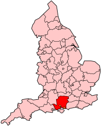
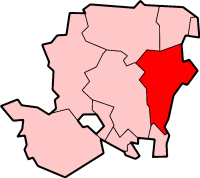
East Hampshire
East Hampshire is een Engels district in het shire-graafschap (non-metropolitan county OF county) Hampshire en telt 121.000 inwoners. De oppervlakte bedraagt 514 km².
| Niet-metropolitaans district in Engeland | |||
|---|---|---|---|
| |||
| Situering | |||
| Land | Engeland | ||
| County | Hampshire | ||
| Regio | South East England | ||
| Coördinaten | 51°0'20"NB, 0°54'30"WL | ||
| Algemeen | |||
| Oppervlakte | 514,4321[1] km² | ||
| Inwoners (2018[2]) |
120.681 (235 inw./km²) | ||
| ONS-code | E07000085 | ||
| Website | Officiële website | ||
| Detailkaart | |||

| |||
| |||
Van de bevolking is 15,9% ouder dan 65 jaar. De werkloosheid bedraagt 1,8% van de beroepsbevolking (cijfers volkstelling 2001).
Plaatsen in district East Hampshire
bewerkenCivil parishes in district East Hampshire
bewerkenAlton, Beech, Bentley, Bentworth, Binsted, Bramshott and Liphook, Buriton, Chawton, Clanfield, Colemore and Priors Dean, East Meon, East Tisted, Farringdon, Four Marks, Froxfield and Privett, Froyle, Grayshott, Greatham, Hawkley, Headley, Horndean, Kingsley, Langrish, Lasham, Lindford, Liss, Medstead, Newton Valence, Petersfield, Ropley, Rowlands Castle, Selborne, Shalden, Sheet, Steep, Stroud, West Tisted, Whitehill, Wield, Worldham.
Bronnen, noten en/of referenties
- ↑ Office for National Statistics → Download → SAM_for_Administrative_Areas_(2018).zip → SAM_LAD_DEC_2018_UK.xlsx. Gearchiveerd op 12 juni 2023.
- ↑ https://www.ons.gov.uk/file?uri=/peoplepopulationandcommunity/populationandmigration/populationestimates/datasets/populationestimatesforukenglandandwalesscotlandandnorthernireland/mid20182019laboundaries/ukmidyearestimates20182019ladcodes.xls Schatting Office for National Statistics: knop MYE5 → kolom Estimated Population mid-2018]