Spelthorne: verschil tussen versies
Verwijderde inhoud Toegevoegde inhoud
Geen bewerkingssamenvatting |
detailkaart |
||
| (3 tussenliggende versies door 2 gebruikers niet weergegeven) | |||
| Regel 1: | Regel 1: | ||
{{Infobox district Verenigd Koninkrijk |
{{Infobox district Verenigd Koninkrijk |
||
| naam = Spelthorne |
| naam = Spelthorne |
||
| soort = [[District (Engeland)|Niet-metropolitaans district]] |
| soort = [[District (Engeland)|Niet-metropolitaans district]] |
||
| wapen = [[Bestand:Spelthorne Council Crest.jpg|85px]] |
|||
| wapen = |
|||
| vlag = |
| vlag = |
||
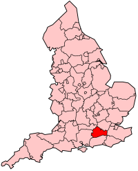
| overzichtskaart = [[Bestand:EnglandSurrey.png|120px]] |
| overzichtskaart = [[Bestand:EnglandSurrey.png|120px]] |
||
| |
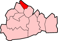
| overzichtskaart1 = [[Bestand:SurreySpelthorne.png|120px]] |
||
| regio = [[South East England]] |
| regio = [[South East England]] |
||
| county = [[Surrey (South East England)|Surrey]] |
| county = [[Surrey (South East England)|Surrey]] |
||
| oppervlak = 44,8879<ref>[https://geoportal.statistics.gov.uk/datasets/standard-area-measurements-2018-for-administrative-areas-in-the-united-kingdom '''O'''ffice for '''N'''ational '''S'''tatistics → Download → SAM_for_Administrative_Areas_(2018).zip → SAM_'''LAD'''_DEC_2018_UK.xlsx.]</ref> |
| oppervlak = 44,8879<ref>[https://geoportal.statistics.gov.uk/datasets/standard-area-measurements-2018-for-administrative-areas-in-the-united-kingdom '''O'''ffice for '''N'''ational '''S'''tatistics → Download → SAM_for_Administrative_Areas_(2018).zip → SAM_'''LAD'''_DEC_2018_UK.xlsx.]</ref> |
||
| bevolking = |
| bevolking = 99.334 |
||
| jaar = 2018<ref>https://www.ons.gov.uk/file?uri=/peoplepopulationandcommunity/populationandmigration/populationestimates/datasets/populationestimatesforukenglandandwalesscotlandandnorthernireland/mid20182019laboundaries/ukmidyearestimates20182019ladcodes.xls Schatting '''O'''ffice for '''N'''ational '''S'''tatistics: knop ''MYE5'' → kolom ''Estimated Population mid-2018'']</ref> |
| jaar = 2018<ref>https://www.ons.gov.uk/file?uri=/peoplepopulationandcommunity/populationandmigration/populationestimates/datasets/populationestimatesforukenglandandwalesscotlandandnorthernireland/mid20182019laboundaries/ukmidyearestimates20182019ladcodes.xls Schatting '''O'''ffice for '''N'''ational '''S'''tatistics: knop ''MYE5'' → kolom ''Estimated Population mid-2018'']</ref> |
||
| dichtheid = 2213 |
| dichtheid = 2213 |
||
| white = 95,4 |
| white = 95,4 |
||
| christen = 75,3 |
| christen = 75,3 |
||
| hindoe = 1,0 |
| hindoe = 1,0 |
||
| moslim = 1,2 |
| moslim = 1,2 |
||
| geenreligie = 14,1 |
| geenreligie = 14,1 |
||
| code = E07000213 |
| code = E07000213 |
||
| detailkaart = Spelthorne UK locator map.svg |
|||
}} |
}} |
||
| Regel 26: | Regel 27: | ||
Voor [[1965]] was Spelthorne een deel van het graafschap [[Middlesex (Londen)|Middlesex]]. |
Voor [[1965]] was Spelthorne een deel van het graafschap [[Middlesex (Londen)|Middlesex]]. |
||
==Plaatsen in district Spelthorne== |
== Plaatsen in district Spelthorne == |
||
* [[Ashford (Surrey)]] |
* [[Ashford (Surrey)]] |
||
* [[Laleham]] |
* [[Laleham]] |
||
Huidige versie van 31 mei 2024 om 19:37
| Niet-metropolitaans district in Engeland | |||
|---|---|---|---|
 | |||
| |||
| Situering | |||
| Land | Engeland | ||
| County | Surrey | ||
| Regio | South East England | ||
| Coördinaten | 51°26'0"NB, 0°30'0"WL | ||
| Algemeen | |||
| Oppervlakte | 44,8879[1] km² | ||
| Inwoners (2018[2]) |
99.334 (2213 inw./km²) | ||
| ONS-code | E07000213 | ||
| Website | Officiële website | ||
| Detailkaart | |||

| |||
| |||
Spelthorne is een Engels district in het shire-graafschap (non-metropolitan county OF county) Surrey en telt 99.000 inwoners. De oppervlakte bedraagt 45 km².
Van de bevolking is 16,7% ouder dan 65 jaar. De werkloosheid bedraagt 2,0% van de beroepsbevolking (cijfers volkstelling 2001).
Voor 1965 was Spelthorne een deel van het graafschap Middlesex.
Plaatsen in district Spelthorne
[bewerken | brontekst bewerken]Bronnen, noten en/of referenties
- ↑ Office for National Statistics → Download → SAM_for_Administrative_Areas_(2018).zip → SAM_LAD_DEC_2018_UK.xlsx.
- ↑ https://www.ons.gov.uk/file?uri=/peoplepopulationandcommunity/populationandmigration/populationestimates/datasets/populationestimatesforukenglandandwalesscotlandandnorthernireland/mid20182019laboundaries/ukmidyearestimates20182019ladcodes.xls Schatting Office for National Statistics: knop MYE5 → kolom Estimated Population mid-2018]