Brussels Airport
| Brussels Airport Luchthaven Brussel-Nationaal (in Dutch) Aéroport de Bruxelles-National (in French) | |||||||||||||||||||
|---|---|---|---|---|---|---|---|---|---|---|---|---|---|---|---|---|---|---|---|
 | |||||||||||||||||||
 | |||||||||||||||||||
| Summary | |||||||||||||||||||
| Airport teep | Military/Public | ||||||||||||||||||
| Operator | Brussels Airport Company Belgian Air Component | ||||||||||||||||||
| Serves | Brussels, Belgium | ||||||||||||||||||
| Location | Zaventem, Belgium | ||||||||||||||||||
| Hub for | |||||||||||||||||||
| Elevation AMSL | 184 ft / 56 m | ||||||||||||||||||
| Coordinates | 50°54′05″N 004°29′04″E / 50.90139°N 4.48444°ECoordinates: 50°54′05″N 004°29′04″E / 50.90139°N 4.48444°E | ||||||||||||||||||
| Wabsteid | brusselsairport.be | ||||||||||||||||||
| Maps | |||||||||||||||||||
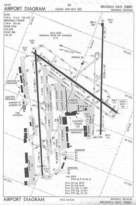 Airport diagram | |||||||||||||||||||
 BRU  BRU | |||||||||||||||||||
| Runways | |||||||||||||||||||
| |||||||||||||||||||
| Statistics (2017) | |||||||||||||||||||
| |||||||||||||||||||
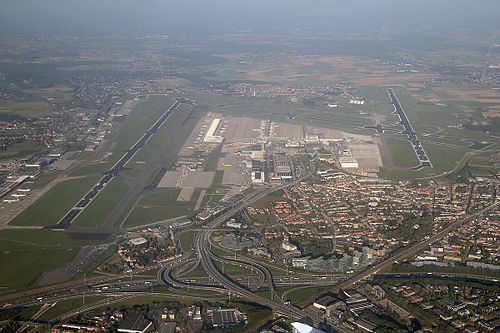
Brussels Airport (IATA: BRU, ICAO: EBBR) (also called Brussel Nationaal/Bruxelles-National/Brussel-Zaventem (Brussels Naitional)) is a internaitional airport 6 NM (11 km; 6.9 mi) northeast[2] o Brussels, the caipital o Belgium. In 2013, ower 19 million passengers arrivit or depairtit at Brussels Airport, makkin it the 25th busiest airport in Europe.
References
- ↑ "Brussels Airport Traffic December 2016". Brussels Airport. Archived frae the original on 13 Januar 2017. Retrieved 1 Juin 2018.
- ↑ a b AIP for EBBR – Brussels Airport frae Belgocontrol
Freemit airtins
Media relatit tae Brussels Airport at Wikimedia Commons