Condom, Gers: Difference between revisions
m reference before punctuation using AWB |
→Climate: Remove an advertising link, see MediaWiki_talk:Spam-blacklist#Advertising_site |
||
| (20 intermediate revisions by 14 users not shown) | |||
| Line 1: | Line 1: | ||
{{Infobox French commune |
{{Infobox French commune |
||
|name = Condom |
|name = Condom |
||
|commune status = [[Subprefectures in France|Subprefecture]] and [[Communes of France|commune]] |
|||
| ⚫ | |||
|image flag |
|image flag = |
||
|flag |
|image flag size = |
||
| ⚫ | |||
|image coat of arms = Blason ville fr Condom (Gers).svg |
|image coat of arms = Blason ville fr Condom (Gers).svg |
||
|image coat of arms size = 70px |
|image coat of arms size = 70px |
||
|coat of arms legend = |
|coat of arms legend = |
||
|city motto = |
|city motto = |
||
|image = Condom.jpg |
|image = Condom.jpg |
||
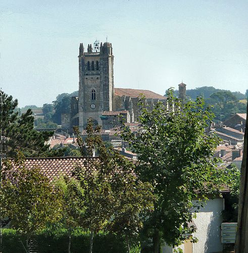
|caption = Condom Cathedral |
|caption = Condom [[Cathedral]]. |
||
|map = |
|map = |
||
|adjustable map = |
|adjustable map = |
||
|time zone = |
|time zone = |
||
| |
|coordinates = {{coord|43.96|0.37|format=dms|display=inline,title}} |
||
|latitude = 43.96 |
|||
|region = Midi-Pyrénées |
|||
|department = Gers |
|||
|arrondissement = Condom |
|arrondissement = Condom |
||
|canton = |
|canton = Baïse-Armagnac |
||
|subdivisions entry = |
|subdivisions entry = |
||
|subdivisions = |
|subdivisions = |
||
|intercommunality = La Ténarèze |
|intercommunality = La Ténarèze |
||
|mayor = Gérard Dubrac |
|mayor = Gérard Dubrac |
||
|party = |
|party = |
||
|term = 2014 |
|term = 2014–2020 |
||
|elevation m = 82 |
|elevation m = 82 |
||
|elevation min m = 62 |
|elevation min m = 62 |
||
|elevation max m = 190 |
|elevation max m = 190 |
||
|area km2 = 97.37 |
|area km2 = 97.37 |
||
| |
|population_demonym = Condomois |
||
|population = |
|population = 6835 |
||
|population ranking = |
|population ranking = |
||
|population date = |
|population date = 2014 |
||
|urban area km2 = |
|urban area km2 = |
||
|urban area date = |
|urban area date = |
||
|urban pop = |
|urban pop = |
||
|urban pop date = |
|urban pop date = |
||
|metro area km2 = |
|metro area km2 = |
||
|metro area date = |
|metro area date = |
||
|metro area pop = |
|metro area pop = |
||
|metro area pop date = |
|metro area pop date = |
||
|INSEE = 32107 |
|INSEE = 32107 |
||
|postal code = 32100 |
|postal code = 32100 |
||
|website = [http://www.condom.org/ www.condom.org] |
|website = [http://www.condom.org/ www.condom.org] |
||
}} |
}} |
||
'''Condom''' ({{lang-oc|Condòm}}), also called '''Condom-en-Armagnac''' or '''Condom-sur-Baïse''', is a [[Communes of France|commune]] in southwestern [[France]] in the [[Departments of France|department]] of [[Gers]], of which it is a [[Prefectures in France|subprefecture]]. |
'''Condom''' ({{lang-oc|Condòm}}), also called '''Condom-en-Armagnac''' or '''Condom-sur-Baïse''', is a [[Communes of France|commune]] in southwestern [[France]] in the [[Departments of France|department]] of [[Gers]], [[Occitanie]] [[Regions of France|region]], of which it is a [[Prefectures in France|subprefecture]]. |
||
Despite their similar names, the [[condom]] was neither invented nor developed in the ''commune'' of Condom. |
|||
==Name of the city== |
==Name of the city== |
||
The name ''Condom'' comes from the [[Gaulish language|Gaulish]] (an ancient [[Celtic languages|Celtic language]] spoken in parts of [[Europe]]) words ''condate-ó-magos'' which means "[[market]] of the [[confluence]]". ''Condatómagos'' |
The name ''Condom'' comes from the [[Gaulish language|Gaulish]] (an ancient [[Celtic languages|Celtic language]] spoken in parts of [[Europe]]) words ''condate-ó-magos'' which means "[[market]] of the [[confluence]]". ''Condatómagos'' later became ''Condatóm'' and then ''Conddóm''. The spelling ''Condom'' first came from [[Latin language|Latin]] in the 10th century as ''{{lang|la|Condomus}}'' or ''{{lang|la|Condomium}}''.<ref>{{cite book| last = Negre| first = Ernest| title = Toponymie generale de la France| url = https://books.google.com/books?id=rsNpi7IVulEC&pg=PA192| year = 1990| publisher = Librairie Droz| isbn = 978-2-600-02883-7| page = 192 }}</ref> |
||
The name of the town has nothing to do with the [[condom]], which in French is called {{lang|fr|préservatif}}. There used to be a museum of condoms in Condom, but it closed in 2005.<ref>{{Cite news|url=http://www.sudouest.fr/2012/08/04/la-capote-colle-toujours-a-la-peau-de-condomtous-les-projets-ont-capote-786852-2362.php|title=La capote colle toujours à la peau de CondomTous les projets ont capoté|newspaper=SudOuest.fr|access-date=2018-02-12|language=fr-FR}}</ref> |
|||
==History== |
==History== |
||
| Line 65: | Line 63: | ||
<center> |
<center> |
||
{| class="wikitable" style="text-align:center" |
{| class="wikitable" style="text-align:center" |
||
|+ Condom and its neighboring ''communes'' |
|||
|- |
|- |
||
| style="border:1px solid black;" | [[File:Map commune FR insee code 32107.png|350px|Map of the ''commune'' de Condom]] |
| style="border:1px solid black;" | [[File:Map commune FR insee code 32107.png|350px|Map of the ''commune'' de Condom]] |
||
|} |
|} |
||
| Line 87: | Line 86: | ||
===Climate=== |
===Climate=== |
||
The climate of Condom, in the [[Köppen climate classification]], is '''Cfb''' - Oceanic climate with template summers. |
The climate of Condom, in the [[Köppen climate classification]], is '''Cfb''' - Oceanic climate with template summers. |
||
==Population== |
==Population== |
||
| ⚫ | With a population of 6, |
||
The inhabitants of Condom are known, in [[French language|French]], as ''Condomois'' (women: ''Condomoises'').<ref>{{cite web|url=http://www.habitants.fr/habitants_condom_32107.html |title=Condom (32100) |publisher=habitants.fr |language=French |accessdate=24 June 2014 |date= }}</ref> |
The inhabitants of Condom are known, in [[French language|French]], as ''Condomois'' (women: ''Condomoises'').<ref>{{cite web|url=http://www.habitants.fr/habitants_condom_32107.html |title=Condom (32100) |publisher=habitants.fr |language=French |accessdate=24 June 2014 |date= }}</ref> |
||
| ⚫ | With a population of 6,835 (2014),<ref name="insee">{{cite web |url=http://www.insee.fr/fr/statistiques/fichier/2525755/dep32.pdf |title=Régions, départements, arrondissements, cantons et communes |work= Populations légales 2014 |publisher=Institut national de la statistique et des études économiques - INSEE |language=French |accessdate=7 March 2017|date= }}</ref> Condom has a [[population density]] of {{Pop density|6835|97.37|km2|prec=0|disp=num}} inhabitants/km<sup>2</sup>. |
||
==Economie== |
|||
<center> |
|||
'''Evolution of the population in Condom''' |
|||
<timeline> |
|||
Colors= |
|||
id:lightgrey value:gray(0.9) |
|||
id:darkgrey value:gray(0.7) |
|||
id:sfondo value:rgb(1,1,1) |
|||
id:barra value:rgb(0.6,0.7,0.8) |
|||
ImageSize = width:500 height:373 |
|||
PlotArea = left:50 bottom:30 top:30 right:30 |
|||
DateFormat = x.y |
|||
Period = from:0 till:8000 |
|||
TimeAxis = orientation:vertical |
|||
AlignBars = justify |
|||
ScaleMajor = gridcolor:darkgrey increment:2000 start:0 |
|||
ScaleMinor = gridcolor:lightgrey increment:1000 start:0 |
|||
BackgroundColors = canvas:sfondo |
|||
BarData= |
|||
bar:1968 text:1968 |
|||
bar:1975 text:1975 |
|||
bar:1982 text:1982 |
|||
bar:1990 text:1990 |
|||
bar:1999 text:1999 |
|||
bar:2006 text:2006 |
|||
bar:2014 text:2014 |
|||
PlotData= |
|||
color:barra width:30 align:left |
|||
bar:1968 from:0 till: 7326 |
|||
bar:1975 from:0 till: 7853 |
|||
bar:1982 from:0 till: 7634 |
|||
bar:1990 from:0 till: 7717 |
|||
bar:1999 from:0 till: 7251 |
|||
bar:2006 from:0 till: 7158 |
|||
bar:2014 from:0 till: 6835 |
|||
PlotData= |
|||
bar:1968 at: 7326 fontsize:S text: 7,326 shift:(-12,5) |
|||
bar:1975 at: 7853 fontsize:S text: 7,853 shift:(-15,5) |
|||
bar:1982 at: 7634 fontsize:S text: 7,634 shift:(-15,5) |
|||
bar:1990 at: 7717 fontsize:S text: 7,717 shift:(-15,5) |
|||
bar:1999 at: 7251 fontsize:S text: 7,251 shift:(-15,5) |
|||
bar:2006 at: 7158 fontsize:S text: 7,158 shift:(-15,5) |
|||
bar:2014 at: 6835 fontsize:S text: 6,835 shift:(-15,5) |
|||
</timeline> |
|||
</center> |
|||
==Economy== |
|||
The ''commune'' of Condom depends mainly of the [[Farming|agriculture]], the [[tourism]] and the [[trade]]. |
The ''commune'' of Condom depends mainly of the [[Farming|agriculture]], the [[tourism]] and the [[trade]]. |
||
| Line 109: | Line 158: | ||
<gallery mode="packed"> |
<gallery mode="packed"> |
||
File:Gers Condom Cathedral of Saint-Pierre outside 01.jpg|Cathedral of Saint Pierre in Condom |
File:Gers Condom Cathedral of Saint-Pierre outside 01.jpg|Cathedral of Saint Pierre in Condom |
||
File:Cloître de Condom.jpg|[[Cloister]] of the |
File:Cloître de Condom.jpg|[[Cloister]] of the cathedral, Condom |
||
File:Condom Gers le port.jpg|Port of Condom on the Baïse river |
File:Condom Gers le port.jpg|Port of Condom on the Baïse river |
||
File:Condom.jpg|Cathedral of Saint Pierre in Condom |
File:Condom.jpg|Cathedral of Saint Pierre in Condom |
||
| Line 115: | Line 164: | ||
==Sister cities== |
==Sister cities== |
||
Condom is twinned with:<ref>{{cite web |url=http://www.condom.org/index.php/relations-internationales |title= |
Condom is twinned with:<ref>{{cite web |url=http://www.condom.org/index.php/relations-internationales |title=Relations internationales |publisher=Condom: City Council website |language=French |accessdate=24 June 2014 |date= |archive-date=25 September 2013 |archive-url=https://web.archive.org/web/20130925100042/http://www.condom.org/index.php/relations-internationales |url-status=dead }}</ref> |
||
* {{Flagicon|Germany}} [[Grünberg, Hesse|Grünberg]], [[Hesse]], Germany |
* {{Flagicon|Germany}} [[Grünberg, Hesse|Grünberg]], [[Hesse]], Germany |
||
* {{Flagicon|Spain}} [[Toro, Zamora|Toro]], [[Castile and León]], Spain |
* {{Flagicon|Spain}} [[Toro, Zamora|Toro]], [[Castile and León]], Spain |
||
| ⚫ | |||
| ⚫ | |||
==Related pages== |
==Related pages== |
||
* [[Arrondissement of Condom]] |
* [[Arrondissement of Condom]] |
||
* [[Communes of the Gers department]] |
* [[Communes of the Gers department]] |
||
| ⚫ | |||
| ⚫ | |||
==Other websites== |
==Other websites== |
||
{{Commons category|Condom (Gers)|Condom}} |
{{Commons category|Condom (Gers)|Condom}} |
||
* |
* [http://www.condom.org/ City Council website] {{in lang|fr}} |
||
* |
* [http://www.tourisme-tenareze.com/ Office de Tourisme - Condom/La Ténarèze] {{in lang|fr}} |
||
{{Gers communes}} |
|||
[[Category:Subprefectures in France]] |
[[Category:Subprefectures in France]] |
||
Latest revision as of 21:22, 31 March 2024
Condom | |
|---|---|
Subprefecture and commune | |
 Condom Cathedral. | |
 Coat of arms | |
Location of Condom  | |
 Condom  Condom | |
| Coordinates: 43°58′N 0°22′E / 43.96°N 0.37°E | |
| Country | France |
| Region | Occitanie |
| Department | Gers |
| Arrondissement | Condom |
| Canton | Baïse-Armagnac |
| Intercommunality | La Ténarèze |
| Government | |
| • Mayor (2014–2020) | Gérard Dubrac |
| Area 1 | 97.37 km2 (37.59 sq mi) |
| Population (2014) | 6,835 |
| • Density | 70/km2 (180/sq mi) |
| Demonym | Condomois |
| Time zone | UTC+01:00 (CET) |
| • Summer (DST) | UTC+02:00 (CEST) |
| INSEE/Postal code | 32107 /32100 |
| Elevation | 62–190 m (203–623 ft) (avg. 82 m or 269 ft) |
| Website | www.condom.org |
| 1 French Land Register data, which excludes lakes, ponds, glaciers > 1 km2 (0.386 sq mi or 247 acres) and river estuaries. | |
Condom (Occitan: Condòm), also called Condom-en-Armagnac or Condom-sur-Baïse, is a commune in southwestern France in the department of Gers, Occitanie region, of which it is a subprefecture.
Name of the city
[change | change source]The name Condom comes from the Gaulish (an ancient Celtic language spoken in parts of Europe) words condate-ó-magos which means "market of the confluence". Condatómagos later became Condatóm and then Conddóm. The spelling Condom first came from Latin in the 10th century as Condomus or Condomium.[1]
The name of the town has nothing to do with the condom, which in French is called préservatif. There used to be a museum of condoms in Condom, but it closed in 2005.[2]
History
[change | change source]After the colonization of the area by the Romans, the Abbey of Saint Pierre was built in 1011. During the Hundred Years' War, the city was taken twice by the English. The Saint Pierre Cathedral was begun in 1507.
Way of St. James
[change | change source]Condom is a town on the Via Podiensis (the Le Puy Route), one of the three major French pilgrimage routes of the Way of St. James. This particular route begins in Le Puy and ends in Santiago de Compostela in northwest Spain. Pilgrims came to Condom from Miradoux and continue on to Larressingle.
Geography
[change | change source]Condom is a commune found along the Baïse river, between Armagnac and Agenais. Condom is the main town of the Condomès or Ténarèze region.
The commune has an area of 97.37 km2 (37.59 sq mi) and its average altitude is 82 m (269 ft); at the city hall, the altitude is 73 m (240 ft).[3]

|
Condom is surrounded by the communes:
- Gers department: Gazaupouy, Castelnau-sur-l'Auvignon, Caussens, Béraut, Maignaut-Tauzia, Cassaigne, Larressingle and Larroque-sur-l'Osse,
- Lot-et-Garonne department: Lannes et Moncrabeau.
Places next to Condom, Gers | |
|---|---|
Climate
[change | change source]The climate of Condom, in the Köppen climate classification, is Cfb - Oceanic climate with template summers.
Population
[change | change source]The inhabitants of Condom are known, in French, as Condomois (women: Condomoises).[4]
With a population of 6,835 (2014),[5] Condom has a population density of 70 inhabitants/km2.
Evolution of the population in Condom
Economy
[change | change source]The commune of Condom depends mainly of the agriculture, the tourism and the trade.
Important agricultural products are Armagnac (an alcoholic beverage like a brandy), Floc de Gascogne (a regional apéritif) and foie gras.
Places of interest
[change | change source]Some of places of interest are:
- Cathédrale Saint-Pierre de Condom (Saint Peter's Cathedral)
- The cloister of the Cathedral.
- Saint-Jacques church
- Musée de l'Armagnac, a museum of the Armagnac drink.
Gallery
[change | change source]-
Cathedral of Saint Pierre in Condom
-
Cloister of the cathedral, Condom
-
Port of Condom on the Baïse river
-
Cathedral of Saint Pierre in Condom


Sister cities
[change | change source]Condom is twinned with:[6]
Grünberg, Hesse, Germany
Toro, Castile and León, Spain
Related pages
[change | change source]References
[change | change source]- ↑ Negre, Ernest (1990). Toponymie generale de la France. Librairie Droz. p. 192. ISBN 978-2-600-02883-7.
- ↑ "La capote colle toujours à la peau de CondomTous les projets ont capoté". SudOuest.fr (in French). Retrieved 2018-02-12.
- ↑ "Condom". Map-France.com. Retrieved 24 June 2014.
- ↑ "Condom (32100)" (in French). habitants.fr. Retrieved 24 June 2014.
- ↑ "Régions, départements, arrondissements, cantons et communes" (PDF). Populations légales 2014 (in French). Institut national de la statistique et des études économiques - INSEE. Retrieved 7 March 2017.
- ↑ "Relations internationales" (in French). Condom: City Council website. Archived from the original on 25 September 2013. Retrieved 24 June 2014.
Other websites
[change | change source]- City Council website (in French)
- Office de Tourisme - Condom/La Ténarèze (in French)