Category:Amlwch
Vai alla navigazione
Vai alla ricerca
Cymraeg: Tref fach a chymuned yng ngogledd Môn, ar lôn yr A5025 tua 15 milltir i'r gogledd o Borthaethwy, hanner ffordd rhwng Cemaes a Moelfre, yw Amlwch. Tref ar lan y môr yw hi, heb draeth ond gyda chlogwynni arfordirol trawiadol. Mae twristiaeth yn elfen bwysig yn yr economi lleol. Ar un adeg roedd yn borthladd eithaf prysur gyda llongau yn hwylio oddi yno i Ynys Manaw a Lerpwl. Mae nifer o'r tai yn dyddio o'r 19eg ganrif ac yn ychwanegu at awyrgylch y dref.
English: Amlwch is the most northerly town and community in Wales. It is situated on the north coast of the Isle of Anglesey, on the A5025 which connects it to Holyhead and to the Menai Bridge. The town has no beach, but it has impressive coastal cliffs. Tourism is an important element of the local economy. At one time it was a busy port, with boats sailing to the Isle of Man and to Liverpool. A number of the houses date from the 19th century and add to the atmosphere of the town.
Español: Amlwch es la localidad más septentrional en Gales, Reino Unido. Es conocida por su patrimonio industrial.
Lietuvių: Amluchas – šiauriausias Velso miestas, įsikūręs Anglesio salos šiaurės rytuose. 3,4 tūkst. gyventojų (2001 m.).
Nederlands: Amlwch is een plaats in Wales, in het bestuurlijke graafschap Anglesey en in het ceremoniële behouden graafschap Gwynedd. De plaats telt 3.438 inwoners.
Svenska: Amlwch är den nordligast belägna orten i Wales, beläget på ön Anglesey. Befolkningen uppgick till 2 092 invånare vid folkräkningen 2001, på en yta av 1,11 kvadratkilometer.
città del Galles, Regno Unito  | |||||
| Carica un file multimediale | |||||
| Istanza di | |||||
|---|---|---|---|---|---|
| Luogo | Amlwch Community, Isle of Anglesey, Galles | ||||
| sito web ufficiale | |||||
 | |||||
Sottocategorie
Questa categoria contiene le 17 sottocategorie indicate di seguito, su un totale di 17.
*
A
- Amlwch railway station (2 F)
B
- Bull Bay, Anglesey (74 F)
- Burwen (24 F)
C
E
- St Eleth's Church, Amlwch (13 F)
H
- Hotels in Amlwch (10 F)
M
- Melin-y-Borth, Amlwch (9 F)
P
- Penrhyn Glas, Anglesey (8 F)
- Pubs in Amlwch (9 F)
S
- Streets in Amlwch (19 F)
W
- Werthyr Standing Stone (2 F)
File nella categoria "Amlwch"
Questa categoria contiene 200 file, indicati di seguito, su un totale di 689.
(pagina precedente) (pagina successiva)-
"The King's Head", Amwlch - geograph.org.uk - 5347826.jpg 4 791 × 3 594; 2,68 MB
-
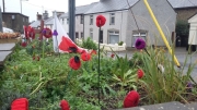
'Weeping Window' poppies, Amlwch - geograph.org.uk - 5946710.jpg 1 024 × 765; 1,04 MB
-
A beautiful bungalow at Graig Lwyd - geograph.org.uk - 748375.jpg 640 × 480; 83 KB
-
A bend in the road - geograph.org.uk - 748682.jpg 640 × 480; 108 KB
-
-
-
A Long Way Down - geograph.org.uk - 1939333.jpg 480 × 640; 315 KB
-
-
A misty Porth Llechog - Bull Bay - geograph.org.uk - 3485680.jpg 4 510 × 3 001; 6,46 MB
-
-
A Road Junction Near Penrhyd Lastra - geograph.org.uk - 245713.jpg 640 × 480; 108 KB
-
-
A tumulus at Pen-y-fynwent - geograph.org.uk - 1300007.jpg 640 × 368; 91 KB
-
A village street, Porthllechog-Bull Bay - geograph.org.uk - 2080710.jpg 589 × 800; 167 KB
-
A5025 Approaching Bull Bay - geograph.org.uk - 1436598.jpg 640 × 480; 119 KB
-
A5025 Eastbound near Refail Bach - geograph.org.uk - 2639602.jpg 640 × 494; 55 KB
-
A5025 entering Bull Bay - geograph.org.uk - 2639610.jpg 640 × 487; 79 KB
-
A5025 In Cerrig-man - geograph.org.uk - 1436509.jpg 640 × 480; 143 KB
-
A5025 Leaving Amlwch - geograph.org.uk - 1436588.jpg 640 × 480; 160 KB
-
A5025 Near Cerrig-man - geograph.org.uk - 1436514.jpg 640 × 480; 129 KB
-
A5025 near Tyddyn-y-Waun - geograph.org.uk - 2639607.jpg 640 × 435; 67 KB
-
Abandoned mine workings - geograph.org.uk - 393042.jpg 640 × 426; 156 KB
-
-
Afon Goch, Amlwch - geograph.org.uk - 3997160.jpg 478 × 640; 114 KB
-
Almwch Harbour - geograph.org.uk - 3179422.jpg 3 600 × 2 144; 3,15 MB
-
Along the road to Rhosybol - geograph.org.uk - 6100721.jpg 1 280 × 960; 877 KB
-
Amlwch - Anglesey August 2009 (3856482829).jpg 2 048 × 1 365; 834 KB
-
Amlwch 1890.jpg 1 409 × 921; 970 KB
-
Amlwch Ambulance Station, Lon Goch - geograph.org.uk - 1111147.jpg 640 × 480; 53 KB
-
Amlwch Coastline - Anglesey August 2009 (3833770597).jpg 2 048 × 1 365; 592 KB
-
Amlwch crossing 1 - geograph.org.uk - 3055681.jpg 640 × 480; 82 KB
-
Amlwch crossing 2 - geograph.org.uk - 3055688.jpg 640 × 480; 88 KB
-
Amlwch Harbour - geograph.org.uk - 2665189.jpg 4 000 × 3 000; 3,5 MB
-
Amlwch Harbour - geograph.org.uk - 3164944.jpg 959 × 645; 156 KB
-
Amlwch Harbour - geograph.org.uk - 5497315.jpg 427 × 640; 95 KB
-
Amlwch playing fields - geograph.org.uk - 3997136.jpg 640 × 511; 57 KB
-
Amlwch Port - geograph.org.uk - 3699387.jpg 800 × 530; 351 KB
-
Amlwch Port - geograph.org.uk - 3699474.jpg 530 × 800; 577 KB
-
Amlwch Port - geograph.org.uk - 3699533.jpg 800 × 530; 425 KB
-
Amlwch Port - geograph.org.uk - 3699552.jpg 530 × 800; 400 KB
-
Amlwch Port - geograph.org.uk - 4576510.jpg 640 × 425; 192 KB
-
Amlwch Port - geograph.org.uk - 6100807.jpg 1 280 × 960; 798 KB
-
Amlwch Port - geograph.org.uk - 6100812.jpg 1 280 × 960; 794 KB
-
Amlwch Port - geograph.org.uk - 6100820.jpg 1 280 × 960; 725 KB
-
Amlwch Port Branch (34234106351).jpg 4 608 × 3 456; 3,88 MB
-
Amlwch Roundabout - geograph.org.uk - 1436523.jpg 640 × 480; 124 KB
-
Amlwch Sail Loft - geograph.org.uk - 4586047.jpg 1 600 × 1 200; 510 KB
-
Amlwch Station, 1962 - geograph.org.uk - 6454356.jpg 1 280 × 847; 301 KB
-
Amlwch Town Council building - geograph.org.uk - 3996992.jpg 640 × 487; 55 KB
-
Amlwch, banner.jpg 640 × 91; 23 KB
-
An informative sign.... - geograph.org.uk - 4586264.jpg 1 600 × 1 200; 483 KB
-
An interesting looking hole - geograph.org.uk - 5476316.jpg 4 000 × 3 000; 3,4 MB
-
An unusual lighthouse-shaped gravestone in cemetery, Burwen - geograph.org.uk - 2240847.jpg 3 000 × 4 000; 2,11 MB
-
-
Anglesey Central Railway, Amlwch - geograph.org.uk - 2410351.jpg 720 × 540; 176 KB
-
Anglesey Coast Path - geograph.org.uk - 3999111.jpg 478 × 640; 103 KB
-
Anglesey Coast Path - geograph.org.uk - 4000636.jpg 640 × 464; 77 KB
-
Anglesey Coastal Path - geograph.org.uk - 3999356.jpg 640 × 478; 96 KB
-
Anglesey Coastal Path - geograph.org.uk - 3999628.jpg 640 × 462; 56 KB
-
Anglesey Coastal Path - geograph.org.uk - 4000145.jpg 640 × 462; 88 KB
-
Anglesey Coastal Path east of Amlwch - geograph.org.uk - 3996916.jpg 640 × 462; 66 KB
-
Anglesey Coastal Path near Amlwch - geograph.org.uk - 3996912.jpg 640 × 466; 74 KB
-
-
-
-
Approaching the Parys Mountain copper mine - geograph.org.uk - 5493643.jpg 2 592 × 1 944; 1,7 MB
-
Approaching the road junction - geograph.org.uk - 1262120.jpg 640 × 480; 121 KB
-
-
-
Armeria maritima - Thrift - geograph.org.uk - 4000637.jpg 640 × 495; 145 KB
-
Associated Octel - geograph.org.uk - 393055.jpg 640 × 426; 94 KB
-
At the Bottom of the Pit - geograph.org.uk - 1939417.jpg 640 × 480; 325 KB
-
B5111 Approaching Amlwch - geograph.org.uk - 1436658.jpg 640 × 480; 146 KB
-
Badly polluted stream - geograph.org.uk - 1169806.jpg 480 × 640; 103 KB
-
Barclays Bank, Salem Street, Amlwch - geograph.org.uk - 1090995.jpg 640 × 480; 59 KB
-
Benchmark on Capel Bethesda (Capel Mawr), Amlwch - geograph.org.uk - 2243363.jpg 3 000 × 4 000; 5,79 MB
-
Benchmark on cemetery gatepost, Burwen - geograph.org.uk - 2243354.jpg 3 000 × 4 000; 5,67 MB
-
Benchmark on old railway bridge, Amlwch - geograph.org.uk - 2243369.jpg 3 000 × 4 000; 5,96 MB
-
Benchmark on St. Eleth's Church, Amlwch - geograph.org.uk - 2051150.jpg 2 888 × 3 544; 3,09 MB
-
-
-
Bend in the road by Pen Parc Bach - geograph.org.uk - 1311885.jpg 640 × 480; 50 KB
-
-
-
-
-
Black Medick (Medicago lupulina) - geograph.org.uk - 1939447.jpg 640 × 480; 339 KB
-
Boats in Amlwch harbour - geograph.org.uk - 3179437.jpg 2 907 × 1 829; 1,85 MB
-
-
Borthwen Brickworks - geograph.org.uk - 1062524.jpg 640 × 427; 101 KB
-
-
-
Bryn Parys - a small holding - geograph.org.uk - 1195716.jpg 640 × 480; 67 KB
-
-
-
Capel Bethesda (Capel Mawr), Amlwch - geograph.org.uk - 2242309.jpg 4 000 × 3 000; 5,8 MB
-
Castell - geograph.org.uk - 4000639.jpg 640 × 478; 118 KB
-
Cattle grazing in drumlin country - geograph.org.uk - 1262710.jpg 640 × 426; 55 KB
-
-
Cemetery south of the B 5111 - geograph.org.uk - 1095195.jpg 640 × 447; 67 KB
-
Chips and beer - geograph.org.uk - 5456529.jpg 4 000 × 2 152; 1,45 MB
-
Cliff top fields - geograph.org.uk - 748693.jpg 640 × 480; 75 KB
-
Cliff top path - geograph.org.uk - 1119987.jpg 640 × 480; 56 KB
-
Cliff top path near Traeth Dynion - geograph.org.uk - 1098611.jpg 640 × 480; 96 KB
-
Cliff top path west of Bull Bay - geograph.org.uk - 1117210.jpg 640 × 480; 55 KB
-
Cliff top west of Porthyrychen - geograph.org.uk - 1417086.jpg 640 × 480; 93 KB
-
-
Cliff top west of Trwyn y Myn - geograph.org.uk - 1119997.jpg 640 × 480; 71 KB
-
Cliffs east of Trwynbychan - geograph.org.uk - 4556440.jpg 640 × 425; 153 KB
-
-
Cliffs overlooking Porth yr Ysgaw - geograph.org.uk - 1410580.jpg 640 × 350; 72 KB
-
Clifftop bungalows at Graig Ddu - geograph.org.uk - 1089447.jpg 640 × 356; 31 KB
-
Coastal Path heading towards Allt Ebolion - geograph.org.uk - 4181325.jpg 1 600 × 1 200; 444 KB
-
Coastal rock exposures - geograph.org.uk - 991295.jpg 640 × 480; 95 KB
-
Coastline above Bull Bay - geograph.org.uk - 5024673.jpg 640 × 427; 69 KB
-
Coastline at Bull Bay - geograph.org.uk - 5900288.jpg 1 600 × 1 200; 366 KB
-
Coastline East of Porth Amlwch - geograph.org.uk - 3935050.jpg 4 320 × 3 240; 2,95 MB
-
Coastline east of Porth Wen - geograph.org.uk - 5468450.jpg 3 996 × 2 997; 2,59 MB
-
Coastline near Trecastell Hotel - geograph.org.uk - 3549829.jpg 640 × 480; 155 KB
-
Cofeb Amlwch 1.jpg 180 × 320; 80 KB
-
Cofeb Amlwch 2.jpg 180 × 101; 62 KB
-
Collapsed Shaft - geograph.org.uk - 1939541.jpg 640 × 480; 265 KB
-
Colour Scheme on Parys Mountain - geograph.org.uk - 3934535.jpg 4 320 × 3 240; 4,17 MB
-
Copper mines near Amlwch - geograph.org.uk - 3776426.jpg 1 600 × 761; 265 KB
-
Copper stream - geograph.org.uk - 2410495.jpg 453 × 604; 121 KB
-
Country Road - geograph.org.uk - 1215975.jpg 640 × 481; 74 KB
-
Cove ^ rocks in Bull Bay - geograph.org.uk - 4190542.jpg 1 600 × 1 200; 501 KB
-
-
Crags above Porth yr Ysgaw - geograph.org.uk - 1410326.jpg 640 × 481; 84 KB
-
-
Cross roads in centre of Amlwch - geograph.org.uk - 2639623.jpg 640 × 446; 67 KB
-
-
Derelict bungalow - geograph.org.uk - 4474134.jpg 640 × 480; 135 KB
-
Derelict cottage at Pen-lon - geograph.org.uk - 1279545.jpg 640 × 480; 69 KB
-
Derelict farm buildings at Bodgadfa - geograph.org.uk - 1262692.jpg 640 × 480; 93 KB
-
-
-
Descent into the Pit - geograph.org.uk - 1939395.jpg 640 × 480; 290 KB
-
Dinorben Square, Amlwch - geograph.org.uk - 3996977.jpg 640 × 467; 58 KB
-
Disused and broken railway track - geograph.org.uk - 5024502.jpg 640 × 427; 126 KB
-
Disused level crossing on the A 5025 - geograph.org.uk - 1105126.jpg 640 × 480; 84 KB
-
Disused Level Crossing, A5025 Amlwch - geograph.org.uk - 1436530.jpg 640 × 480; 159 KB
-
Disused level crossing, Amlwch - geograph.org.uk - 3997143.jpg 640 × 478; 85 KB
-
Disused Opencast Mine on Parys Mountain - geograph.org.uk - 3932113.jpg 4 320 × 3 240; 3,81 MB
-
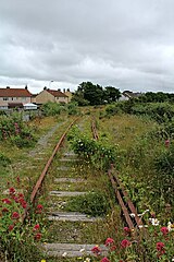
Disused railway line - geograph.org.uk - 6092380.jpg 1 024 × 683; 189 KB
-
Disused railway line - geograph.org.uk - 6092382.jpg 1 024 × 683; 172 KB
-
-
Disused railway track at Amlwch (2) - geograph.org.uk - 5024929.jpg 640 × 427; 78 KB
-
Disused railway track at Amlwch (3) - geograph.org.uk - 5025093.jpg 427 × 640; 85 KB
-
Disused railway track at Amlwch - geograph.org.uk - 5024504.jpg 427 × 640; 83 KB
-
Disused Railway, Amlwch - geograph.org.uk - 4787236.jpg 1 600 × 1 200; 716 KB
-
Down in the big opencast - geograph.org.uk - 5476312.jpg 4 000 × 3 000; 2,6 MB
-
-
Dry Dock at Amlwch - geograph.org.uk - 4637119.jpg 640 × 480; 68 KB
-
-
-
Entering Amlwch - geograph.org.uk - 231851.jpg 640 × 480; 106 KB
-
Entrance to Maes William Williams VC - geograph.org.uk - 1111364.jpg 640 × 317; 34 KB
-
Equestrian Wall - geograph.org.uk - 4190372.jpg 1 600 × 1 200; 400 KB
-
Ex-British Fuels garage, Amlwch - geograph.org.uk - 3776467.jpg 1 024 × 589; 112 KB
-
Farm road to Glanllyn Farm - geograph.org.uk - 1279417.jpg 640 × 480; 107 KB
-
Farmland west of Pen y Fynwent - geograph.org.uk - 1311728.jpg 640 × 340; 43 KB
-
Feeding the Swans near Porthwen Anglesey - geograph.org.uk - 2504975.jpg 3 264 × 2 176; 2,95 MB
-
-
Ffos y Defaid - geograph.org.uk - 1117206.jpg 480 × 640; 82 KB
-
Field south of the A 5025 - geograph.org.uk - 1093406.jpg 640 × 313; 37 KB
-
Fields to the rear of The Lodge - geograph.org.uk - 1402645.jpg 640 × 411; 59 KB
-
Fields to the west of Capel Newydd - geograph.org.uk - 1402922.jpg 640 × 480; 71 KB
-
Fish and chip shop, Amlwch - geograph.org.uk - 3783454.jpg 1 600 × 974; 269 KB
-
-
Five sailed windmill Parys Mountain - geograph.org.uk - 4636607.jpg 640 × 480; 91 KB
-
Flower boat at Bull Bay, Anglesey. - geograph.org.uk - 6172219.jpg 2 560 × 1 920; 1,63 MB
-
-
Flush Bracket - geograph.org.uk - 1939574.jpg 480 × 640; 306 KB
-
Folded strata - geograph.org.uk - 991309.jpg 640 × 480; 89 KB
-
Footpath to Afon Goch - geograph.org.uk - 402722.jpg 640 × 480; 73 KB
-
-
Footpath to Traeth Dynion - geograph.org.uk - 1098137.jpg 640 × 480; 58 KB
-
Footpath ^ disclaimer notice - geograph.org.uk - 4586234.jpg 1 600 × 1 200; 577 KB
-
Former Associated Octel site, Amlwch - geograph.org.uk - 3999130.jpg 640 × 474; 64 KB
-
-
Geo leading to Ogof Gaseg - geograph.org.uk - 1124674.jpg 640 × 480; 100 KB
-
Geo leading to Ogof Trwyn Myn - geograph.org.uk - 1122118.jpg 640 × 480; 77 KB
-
GeoMon Clock at Amlwch Port - geograph.org.uk - 3996934.jpg 640 × 478; 106 KB
-
Getting very near to the edge - geograph.org.uk - 1119921.jpg 640 × 480; 127 KB
-
-
Glacial erratic at Porth Newydd - geograph.org.uk - 1417870.jpg 640 × 480; 74 KB
-
-
-
-
-
Gorse hedges - geograph.org.uk - 1279996.jpg 640 × 480; 103 KB
-
-
Grassland west of the railway bridge - geograph.org.uk - 1310308.jpg 640 × 481; 53 KB
-
Grazing land east of Porth Wen - geograph.org.uk - 1100845.jpg 640 × 480; 50 KB
-
-
Grazing sheep near Maes Glas - geograph.org.uk - 1300625.jpg 640 × 446; 55 KB
-
-
-
Green buoy at Porth Amlwch - geograph.org.uk - 4639648.jpg 480 × 640; 84 KB