Category:Antonine Wall
Aller à la navigation
Aller à la recherche
|
Ce site est inscrit au Patrimoine Mondial de l'UNESCO sous l'intitulé :
Frontiers of the Roman Empire.
|

fortification romaine en Écosse  Ruta de la Muralla Antonina prop de Bar Hill  Posició del mur de Antoní respecte al d'Adrià | |||||
| Téléverser des médias | |||||
| Nature de l’élément | |||||
|---|---|---|---|---|---|
| Partie de |
| ||||
| Nommé(e) en référence à | |||||
| Lieu | Écosse | ||||
| Commanditaire | |||||
| Comprend | |||||
| Statut patrimonial |
| ||||
| Date de fondation ou de création |
| ||||
| Remplace |
| ||||
 | |||||
Sous-catégories
Cette catégorie comprend 8 sous-catégories, dont les 8 ci-dessous.
D
F
R
- RIB I 2146 (2 F)
- RIB I 2197 (1 F)
- Roman Bridge, Duntocher (7 F)
- Roughcastle Tunnel (11 F)
S
- Shirva, Twechar (9 F)
T
- The Roman wall in Scotland (1911) (109 F)
Pages dans la catégorie « Antonine Wall »
Cette catégorie comprend seulement la page ci-dessous.
Média dans la catégorie « Antonine Wall »
Cette catégorie comprend 110 fichiers, dont les 110 ci-dessous.
-
2015.104912.Proceedings-Of-The-Society-Of-Antiquaries-Of-Scotland-1914-1915-Vol49 0170.jpg 3 624 × 4 396 ; 1,43 Mio
-
2015.104912.Proceedings-Of-The-Society-Of-Antiquaries-Of-Scotland-1914-1915-Vol49 0171.jpg 4 620 × 3 753 ; 1,25 Mio
-
A different looking Antonine Wall - geograph.org.uk - 1523264.jpg 640 × 480 ; 102 kio
-
Antonine Wall - geograph.org.uk - 1460062.jpg 640 × 359 ; 79 kio
-
Antonine Wall - geograph.org.uk - 1464443.jpg 640 × 480 ; 174 kio
-
Antonine Wall - geograph.org.uk - 49196.jpg 640 × 480 ; 148 kio
-
Antonine Wall at Watling Lodge (geograph 3175254).jpg 1 200 × 1 600 ; 806 kio
-
Antonine Wall ditch above the Roughcastle Canal Tunnel, Falkirk, Scotland.jpg 4 490 × 3 294 ; 8,27 Mio
-
Antonine Wall ditch looking east at Roughcastle, Falkirk, Scotland.jpg 4 468 × 3 260 ; 7,21 Mio
-
Antonine Wall ditch looking west at Roughcastle, Falkirk, Scotland.jpg 4 608 × 3 456 ; 6,26 Mio
-
Antonine Wall monument, Auld Kirk Museum, Kirkintilloch, East Dunbartonshire.jpg 1 920 × 1 080 ; 844 kio
-
Antonine Wall Plaque - geograph.org.uk - 4256323.jpg 640 × 480 ; 84 kio
-
Antonine Wall, near Bar Hill - geograph.org.uk - 5431131.jpg 3 264 × 1 836 ; 2,73 Mio
-
Antonine wall.JPG 320 × 240 ; 14 kio
-
Antonine's Wall at Watling Lodge - geograph.org.uk - 1140335.jpg 640 × 415 ; 87 kio
-
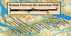
Antonine.Wall.Roman.forts.jpg 1 513 × 778 ; 257 kio
-
Antoninus Wall near Bar Hill.jpg 4 000 × 2 250 ; 5,83 Mio
-
Antoninus Wall near Bonnybridge.jpg 3 968 × 2 976 ; 7,68 Mio
-
Antoninus Wall W of Bonnybridge.jpg 4 000 × 2 250 ; 3,54 Mio
-
Antoninuswall Karte.png 800 × 995 ; 432 kio
-
Bar Hill.jpg 633 × 475 ; 450 kio
-
Bothwellhaugh.png 1 003 × 841 ; 1,33 Mio
-
Canal and towpath - geograph.org.uk - 6409527.jpg 1 600 × 1 131 ; 440 kio
-
Canal at Twechar - geograph.org.uk - 422564.jpg 640 × 480 ; 91 kio
-
Canal maintenance - geograph.org.uk - 6409545.jpg 1 600 × 1 043 ; 384 kio
-
Canal maintenance - geograph.org.uk - 6409550.jpg 1 600 × 1 136 ; 500 kio
-
Country Lane beside Golf Course - geograph.org.uk - 48117.jpg 640 × 457 ; 104 kio
-
Course of the Antonine Wall at Bar Hill - geograph.org.uk - 308685.jpg 640 × 480 ; 166 kio
-
Ditch associated with Antonine Wall at Bar Head - geograph.org.uk - 365380.jpg 640 × 427 ; 156 kio
-
Ditch of the Antonine Wall at Watling Lodge (geograph 1649848).jpg 640 × 410 ; 100 kio
-
Exposed stone base of the Antonine Wall - geograph.org.uk - 1511463.jpg 640 × 341 ; 89 kio
-
Farm Diversification Bo'ness - geograph.org.uk - 81875.jpg 640 × 480 ; 81 kio
-
-
-
Forth and Clyde Canal - geograph.org.uk - 6409518.jpg 1 600 × 1 200 ; 502 kio
-
Fortlet Tartlet, Roman Bake-Off, Callendar House.jpg 2 117 × 3 771 ; 4,96 Mio
-
Grange Primary School - geograph.org.uk - 531382.jpg 640 × 480 ; 84 kio
-
Grangemouth from Inveravon. - geograph.org.uk - 112172.jpg 480 × 640 ; 90 kio
-
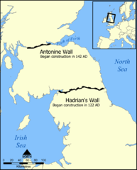
Hadrians Wall map heb.png 800 × 995 ; 229 kio
-
Hadrians Wall map hr.svg 800 × 995 ; 216 kio
-
Hadrians Wall map mak.png 800 × 995 ; 243 kio
-
Hadrians Wall map mk.svg 800 × 995 ; 337 kio
-
Hadrians Wall map Swedish.png 800 × 995 ; 233 kio
-
Hadrians Wall map-ca.svg 800 × 995 ; 217 kio
-
Hadrians Wall map-es.svg 800 × 995 ; 217 kio
-
Hadrians Wall map-fa.svg 800 × 995 ; 193 kio
-
Hadrians Wall map-fi.png 800 × 995 ; 250 kio
-
Hadrians Wall map-fr.svg 800 × 995 ; 218 kio
-
Hadrians Wall map-id.svg 800 × 995 ; 222 kio
-
Hadrians Wall map-lv.svg 800 × 995 ; 217 kio
-
Hadrians Wall map-ru.svg 800 × 995 ; 217 kio
-
Hadrians Wall map-sr.svg 800 × 995 ; 217 kio
-
Hadrians Wall map.png 800 × 995 ; 215 kio
-
Hadrians Wall map.svg 800 × 995 ; 226 kio
-
Inveravon. - geograph.org.uk - 112161.jpg 640 × 480 ; 81 kio
-
-
Map of the Flight of locks at Falkirk.png 836 × 908 ; 896 kio
-
Mapa paret d'adrian.png 800 × 995 ; 214 kio
-
Military Way at Seabegs Wood - geograph.org.uk - 930390.jpg 640 × 480 ; 107 kio
-
Millstones in Goldenhill Park - geograph.org.uk - 1511442.jpg 640 × 480 ; 113 kio
-
Muroj de Hadriano kaj de Antonino.svg 800 × 995 ; 217 kio
-
Ordnance Survey Map of the Antonine Wall, Published 1969 Composite.jpg 62 525 × 13 260 ; 122,45 Mio
-
Ordnance Survey Map of the Antonine Wall, Published 1969.jpg 12 242 × 9 784 ; 50 Mio
-
Ordnance Survey part of 25-inch Sheet XXX.2 Falkirk Antonine Wall, Published 1897.jpg 4 605 × 1 621 ; 1,49 Mio
-
-
-
Picts (Two Left Feet) and runners at the Roman vs Picts 5k race, Callendar House.jpg 2 699 × 1 513 ; 1,18 Mio
-
Picts (Two Left Feet) at the finish line, Roman vs Picts 5k race, Callendar House.jpg 3 280 × 2 320 ; 1,79 Mio
-
Picts (Two Left Feet) at the finish, Roman vs Picts 5k race, Callendar House.jpg 3 665 × 2 592 ; 2,21 Mio
-
Picts (Two Left Feet) at the Roman Bake-off, Callendar House.jpg 3 446 × 2 438 ; 2,25 Mio
-
Picts (Two Left Feet) before the Roman vs Picts 5k race, Callendar House.jpg 2 988 × 5 312 ; 2,69 Mio
-
Picts (Two Left Feet) cheer a runner at the Roman vs Picts 5k race, Callendar House.jpg 4 608 × 2 592 ; 2,73 Mio
-
Picts (Two Left Feet) cheer on a child runner at the Roman vs Picts 5k race, Callendar House.jpg 1 967 × 2 117 ; 2,49 Mio
-
Picts (Two Left Feet) cheer on a runner at the Roman vs Picts 5k race, Callendar House.jpg 5 312 × 2 988 ; 2,54 Mio
-
Picts (Two Left Feet) in formation at the Roman vs Picts 5k race, Callendar House.jpg 3 914 × 2 936 ; 3,21 Mio
-
Picts (Two Left Feet) in human pyramid at the Roman vs Picts 5k race, Callendar House.jpg 2 592 × 3 670 ; 2,76 Mio
-
Polmont banner Roman Vallum of the Antonine Wall.jpg 2 450 × 350 ; 489 kio
-
Recent harvest with a secret - geograph.org.uk - 554143.jpg 640 × 480 ; 82 kio
-
Relics of the Antonine Wall, Milngavie - geograph.org.uk - 49092.jpg 640 × 480 ; 182 kio
-
Rocky Roman Road, Roman Bake-Off, Callendar House.jpg 5 312 × 2 988 ; 3,48 Mio
-
Roman Bake-Off, Callendar House.jpg 2 988 × 5 312 ; 3,78 Mio
-
Roman pesto made with ground elder by Anna Canning of Floramedica.jpg 4 608 × 2 592 ; 3,05 Mio
-
Roman Vallum of the Antonine Wall, Scotland.jpg 2 560 × 1 920 ; 2,04 Mio
-
Romanfortatbalmu00mill orig 0147.png 2 764 × 1 456 ; 3,49 Mio
-
Romanfortatbalmu00mill orig 0177.png 2 916 × 968 ; 3,01 Mio
-
Romanfortatbalmu00mill orig 0221.png 2 211 × 1 494 ; 2,92 Mio
-
Romanfortatbalmu00mill orig 0233.png 2 937 × 1 245 ; 4,08 Mio
-
Romanfortatbalmu00mill orig 0239.png 2 868 × 1 396 ; 3,53 Mio
-
-
-
Runner cheered by Picts (Two Left Feet) at the Roman vs Picts 5k race, Callendar House.jpg 2 805 × 1 584 ; 980 kio
-
Runners dressed as Picts and Romans complete the 5k race at Callendar House.jpg 3 547 × 2 660 ; 3,92 Mio
-
Sign at site of Roman influence - geograph.org.uk - 900122.jpg 480 × 640 ; 183 kio
-
Site of the Antonine Wall. - geograph.org.uk - 90434.jpg 640 × 480 ; 73 kio
-
Start of the Romans Vs Picts 5k race, Callendar House.jpg 5 312 × 2 988 ; 6,81 Mio
-
Summit of Crow Hill - geograph.org.uk - 56822.jpg 640 × 480 ; 155 kio
-
The Antonine Wall at Dullatur - geograph.org.uk - 1522990.jpg 480 × 640 ; 136 kio
-
The Antonine Wall in Strone Plantation - geograph.org.uk - 2782002.jpg 640 × 480 ; 99 kio
-
-
The Antonine Wall near Westerwood - geograph.org.uk - 1523007.jpg 480 × 640 ; 142 kio
-
The Antonine Wall, Rome's final frontier, the Hunterian Museum..JPG 4 288 × 2 848 ; 7,88 Mio
-
The ditch associated with the Antonine Wall (geograph 2794338).jpg 428 × 640 ; 106 kio
-
The Wall - geograph.org.uk - 282048.jpg 640 × 480 ; 115 kio
-
The Wall, The Road and The Canal - geograph.org.uk - 1747771.jpg 968 × 648 ; 199 kio
-
Titulihunteriani00macdrich raw 0151 RIB2201v2.png 408 × 732 ; 391 kio
-
Titulihunteriani00macdrich raw 0151 RS33.png 313 × 667 ; 306 kio
-
Twechar - geograph.org.uk - 87783.jpg 640 × 480 ; 165 kio
-
Veni Vidi Victoria Sponge Cake, Roman Bake-Off, Callendar House.jpg 2 117 × 3 771 ; 4,71 Mio
-
WallOfSeverusEngraving1854.jpg 988 × 636 ; 723 kio
-
William Roy Plate XXIX Roman Station Camelon Antonine Wall.jpg 3 208 × 4 821 ; 4,19 Mio