Category:Lesser Antilles
Jump to navigation
Jump to search
island arc in the Caribbean Sea   | |||||
| Վերբեռնել մեդիա նիշք | |||||
| Հասկացության մասնավոր դեպք | |||||
|---|---|---|---|---|---|
| Վայր |
| ||||
| Գտնվում է ափին | |||||
| Կազմված է | |||||
| Մակերես |
| ||||
| Բարձրություն ծովի մակարդակից |
| ||||
 | |||||
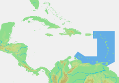
The Lesser Antilles (“Antillas Menores” in Spanish, “Petites Antilles” in French) is a large archipelago in the Caribbean Sea, comprising smaller islands in the East and South of Antilles; they are subdivided into two or three subgroups:
- the “Windward Antilles”, “islas de Barlovento” in Spanish, “îles du Vent” in French (the eastern subgroup), forming a volcanic arc to the East, preferably subdivided in English into:
- the “Leeward Islands” (the northeastern subgroup), to the north of latitude 15°N and the east of longitude 65°00′W, between the Virgin Islands and Dominica, generally extended to Isla de Aves;
- the “Windward Islands” (the southeastern subgroup), to the south of latitude 15°N and the east of longitude 62°30′W, between Martinique and Grenada, generally extended to Trinidad and Tobago;
- the “Leeward Antilles”, “islas de Sotavento” in Spanish, “îles sous le Vent” in French (the southwestern subgroup), along the Northern coast of South America (rarely extended to Trinidad and Tobago or Isla de Aves).
Note:
- The Netherlands Antilles is a former dependency of the Kingdom of the Netherlands located in the two “Leeward” subgroups of the Lesser Antilles.
Ենթակատեգորիաներ
Ստորև բերված է այս կատեգորիայի 5 ենթակատեգորիա՝ 5-ից։
I
«Lesser Antilles» կատեգորիայի մեդիան
Ստորև բերված է այս կատեգորիայի 36 նիշք՝ 36-ից։
-
De-Kleine Antillen.ogg 2,0 վ; 20 ԿԲ
-
142567479264539 final x.png 2000 × 2000; 503 ԿԲ
-
-
Aboard S.V. Polynesia (520910009).jpg 426 × 640; 94 ԿԲ
-
Aboard SV Polynesia (288580292).jpg 1200 × 1600; 397 ԿԲ
-
Aboard the S. V. Polynesia (520908343).jpg 426 × 640; 99 ԿԲ
-
Aboard the S. V. Polynesia (520908801).jpg 640 × 426; 84 ԿԲ
-
Aboard the S. V. Polynesia (520909531).jpg 426 × 640; 87 ԿԲ
-
Aboard Windjammer SV Polynesia (520931194).jpg 640 × 426; 77 ԿԲ
-
Arrowsmith - Map of the West Indies.jpg 5880 × 5010; 5,22 ՄԲ
-
At night aboard Windjammer Polynesia (288575429).jpg 1600 × 1200; 447 ԿԲ
-
Atlas Van der Hagen-KW1049B13 082-CANIBALES INSULAE.jpeg 5500 × 4362; 3,38 ՄԲ
-
Capsized.jpg 1020 × 728; 392 ԿԲ
-
Caribbean - Lesser Antilles-2010-24-05.PNG 703 × 495; 47 ԿԲ
-
Caribbean - Lesser Antilles.PNG 703 × 495; 47 ԿԲ
-
Cliff Jumping.jpg 1020 × 682; 355 ԿԲ
-
Come Get Wet.jpg 1020 × 680; 264 ԿԲ
-
Dive In.jpg 1020 × 680; 282 ԿԲ
-
Eastern Lesser Antilles (Barbuda to Grenada) satellite image.jpg 2400 × 3200; 1,1 ՄԲ
-
Geologisches Pulverfass Karibik.webm 28 վ, 1920 × 1080; 30,28 ՄԲ
-
Insect pests of the Lesser Antilles (IA insectpestsofles00ballrich).pdf 760 × 1125, 236 էջ; 31,2 ՄԲ
-
Lesser Antilles 250m.jpg 838 × 1120; 424 ԿԲ
-
LocationLesserAntilles.png 394 × 286; 4 ԿԲ
-
Map of Lesser Antilles WDL10077.png 1422 × 1024; 2,96 ՄԲ
-
Map of OECS.svg 1807 × 1456; 790 ԿԲ
-
Maritime boundaries between UK and France in Antilles-fr.svg 1502 × 1332; 403 ԿԲ
-
Moody Beach.jpg 1020 × 680; 151 ԿԲ
-
Palms In The Sand.jpg 1020 × 680; 318 ԿԲ
-
PAT - Lesser Antilles.gif 1900 × 1600; 238 ԿԲ
-
Petites-Antilles NASA 64.82403W 14.61341N.jpg 1280 × 978; 83 ԿԲ
-
Saba Corniche.jpg 6623 × 2139; 7,65 ՄԲ
-
So entstanden Höhlen in der Karibik.webm 1 ր 0 վ, 1920 × 1080; 59,54 ՄԲ
-
The Caribbean Islands -(West Indies) 2014-04-24 09-48.gif 433 × 379; 13 ԿԲ
-
The Lesser Antilles arc.webp 1299 × 1657; 362 ԿԲ
-
The Wharf.jpg 1020 × 680; 307 ԿԲ
-
USGS Shakemap - 1974 Lesser Antilles earthquake.jpg 612 × 718; 68 ԿԲ