„Kerelaw Castle“ – Versionsunterschied
| [ungesichtete Version] | [gesichtete Version] |
K →Sources: authorlink |
Rknbg (Diskussion | Beiträge) K Vorlagenparameter korrigiert Markierung: 2017-Quelltext-Bearbeitung |
||
| (47 dazwischenliegende Versionen von 32 Benutzern werden nicht angezeigt) | |||
| Zeile 1: | Zeile 1: | ||
{{Infobox |
{{Infobox Burg |
||
| |
|Name = Kerelaw Castle |
||
|Bild = Kerelaw castle.jpg |
|||
|location = [[Stevenston]], [[North Ayrshire]], [[Scotland]] |
|||
|Bildbeschreibung = Kerelaw Castle 2006 |
|||
|coordinates = {{coord|55.6484|-4.7523|}} |
|||
|Bilderwunsch = |
|||
|image = [[Image:Kerelaw castle.jpg|300px]] |
|||
|Alternativname = |
|||
|caption = Kerelaw Castle in 2006 |
|||
|Entstehungszeit = um 1191,<br />wieder aufgebaut nach 1488 |
|||
|map_type = Scotland North Ayrshire |
|||
|Typologie n. geo. Lage = [[Niederungsburg]] |
|||
|latitude = 55.6484 |
|||
|Erhaltungszustand = Ruine |
|||
|longitude = -4.7523 |
|||
|Ständische Stellung = Schottischer Adel |
|||
|map_caption = Location within North Ayrshire |
|||
|Mauerwerksmerkmale = Bruchstein |
|||
|map_size = 300 |
|||
|Heutiger Ortsname = [[Stevenston]] |
|||
|type = Stone |
|||
|Breitengrad = 55.6484 |
|||
|built = c. 1191, rebuilt after 1488 |
|||
|Längengrad = -4.7523 |
|||
|builder = Stephen Lockhart |
|||
| |
|Unauffindbar = |
||
|Region-ISO = GB-NAY |
|||
|used = c. 1191 to 1787 |
|||
|Poskarte = |
|||
|condition = Ruined |
|||
|Höhenordinate = 19 |
|||
|ownership = [[North Ayrshire Council]] |
|||
|Höhe-Bezug = GB |
|||
|open_to_public = Yes, with limited access |
|||
|controlledby = |
|||
}} |
}} |
||
'''Kerelaw Castle''' ist eine [[Ruine|Burgruine]] in Stadt [[Stevenston]] in der der [[Schottland|schottischen]] Verwaltungseinheit [[North Ayrshire]]. |
|||
== Geschichte == |
|||
'''Kerelaw Castle''' is a [[castle]] [[ruin]] situated on the coast of [[North Ayrshire]], [[Scotland]] in the town of [[Stevenston]]. |
|||
Die Burg, die auch ''Kerila Castle'' oder ''Turnlaw Castle'' genannt wurde,<ref name="RobertsonC133" /><ref name="Clements17" /> soll laut ''Timothy Pont'' ab 1191 von ''Richard de Morville'' für die ''Lockharts'' gehalten worden sein,<ref name="Dobie252253" /> nachdem ''Stephen Lockhart'' (oder ''Loccard'')<ref name="Macintosh329" /> ein Stück Land in [[Ayrshire]] zugesprochen bekam. Dieses Land nannte er „Stevenstoune“ (später „Stevenston“) nach sich selbst und das [[Herrenhaus (Gebäude)|Herrenhaus]] des Baronats Stevenston nannte man „Kerelaw“.<ref name="Dobie370" /> Burg und Baronat wurden später an die ''Campbells'' von ''Loudoun'' und noch später an die ''Cunninghames'' (oder ''Cunninghams'', bzw. ''Cuninghames'') von [[Kilmaurs]] übertragen. Während sich die Burg in den Händen der Cunninghames befand, wurde sie 1488 im Zuge der gut belegten, lang andauernden Fehde zwischen diesen beiden prominenten Familien aus Ayrshire von [[Hugh Montgomerie, 1. Earl of Eglinton]], geplündert und niedergebrannt.<ref name="RobertsonB1516" /> Die Cunninghames brannten unter der Führung des [[Earl of Glencain|Earls of Glencairn]] 1528 [[Eglinton Castle]] als Rache bis auf die Grundmauern nieder.<ref name="RobertsonB1329" /> |
|||
[[Datei:Kerelaw castle stevenston ayrshire.jpg|mini|links|Kerila oder Kerelaw Castle in den 1860er-Jahren.<ref name="PatersonB561" />]] |
|||
== History == |
|||
Kerelaw Castle wurde irgendwann nach 1488 wieder aufgebaut und soll eine Reihe geschnitzter Wappenschilder des schottischen Adels enthalten haben, die man von der [[Kilwinning Abbey]] genommen hatte.<ref name="Billings41" /> Neun Fischern der [[Saltcoats]] wurde 1545 Land gegen den Transport der Möbel des Earls vom Bach der Saltcoats auf dem [[Clyde (Fluss)|Clyde]] nach ''Finlayston'' jedes Frühjahr und den Rücktransport jeden Herbst, wenn die Familie für die Wintermonate auf Kerelaw Castle zurückkehrte, Land verpachtet. Ein halbes Fass Heringe musste ebenfalls jährlich dem Earl geliefert werden.<ref name="PatersonB558" /> |
|||
=== Wohnsitz der Äbte === |
|||
This castle, variously named Kerelaw, Kerila or even Turnlaw,<ref name="Robertson1">Robertson (1908), p. 133</ref><ref name="Clements">Clements, James. A reference to the 'Lords of Turnlaw', p. 17.</ref> is said by [[Timothy Pont]] to have been held by the [[Lockharts]] from [[Richard de Morville]], Constable of Scotland, as far back as 1191,<ref name="Dobie">Dobie, p. 252-3</ref> after Stephen Lockhart or Loccard<ref name="Macintosh">Macintosh, p. 329</ref> obtained a grant of land in Ayrshire. This land would be named Stevenstoune (later [[Stevenston]]) after himself, and their manor-place of the barony of Stevenston, named Kerelaw.<ref name="Dobie2">Dobie, p. 370</ref> The castle and barony were eventually passed on to the Campbells of Loudoun and later to the [[Earl of Glencairn|Cunninghames]] (or Cunninghams/Cuninghames) of [[Kilmaurs]]. It was in the Cunninghame's possession in 1488 that the castle was sacked and burned by the [[Hugh_Montgomerie,_1st_Earl_of_Eglinton|2nd Lord Montgomerie]], during the well documented and long-term feud between these two prominent Ayrshire families.<ref name="Robertson">Robertson (1889), p. 15-16</ref> The Cunninghames, led by the Earl of Glencairn burned [[Eglinton Castle]] to the ground in revenge in 1528.<ref name="Robertson2">Robertson (1889), p. 13-29</ref> |
|||
Laut einer örtlichen Legende soll die Burg der Sitz des Abtes von [[Kilwinning]] gewesen sein, was möglicherweise auf die Tatsache zurückzuführen ist, dass der dritte Sohn von [[Alexander Cunningham, 1. Earl of Glencairn]], nach der [[Reformation]] abwesender Abt der Abtei war und auf Kerelaw Castle gewohnt haben könnte. |
|||
[[Datei:Kerelaw castle2.jpg|mini|Südliche Mauer der Burgruine 2006]] |
|||
=== Spätere Geschichte === |
|||
[[Image:Kerelaw castle stevenston ayrshire.jpg|left|thumb|Kerila or Kerelaw Castle in the 1860s<ref name="Paterson32">Paterson, Vol. 5, p. 561</ref>]] |
|||
[[Datei:Armorial of Hamilton of Grange (1823).jpg|mini|links|Wappen der Hamiltons von Grange<ref name="RobertsonBT6" />]] |
|||
1609 kaufte Sir ''Thomas Boyd'' das Anwesen und verkaufte es bald an Sir ''William Cunninghame'' aus ''Cunninghamhead'' weiter. 30 Jahre später kaufte Sir ''Robert Cunninghame'' aus ''Auchenharvie'' die Burg und die umgebenden Ländereien. 1655 kaufte ''John Hamilton'' aus ''Cambuskeith'' (heute „The Mount“), später aus ''Grange'', (Großvater von [[Alexander Hamilton]], einem Gründungsvater der USA) Kerelaw Castle und benannte es ist „Grange Castle“ nach seinem Familienhaus in [[Kilmarnock]] um. ''Clements'' und ''Graham'' geben das Jahr 1685 als Datum für den Verkauf von „Kerila“ (Kerelaw) an ''John Hamilton'' an.<ref name="Clements13" /><ref name="Graham44" /> Bis 1787 war die Burg der Sitz der Familie ''Hamilton''; dann ließ ein weiterer ''Alexander Hamilton'' (Vetter 2. Grades des US-amerikanischen Politikers) [[Kerelaw House]] (auch „Grange House“) in der Nähe erbauen. Die Burg wurde bald aufgegeben.<ref name="Macintosh330" /> |
|||
Den Grundstein des neuen [[Eglinton Castle]] in Kilwinning ließ Alexander Hamilton of Grange 1797 für den 12. Earl of Eglinton legen.<ref name="Tournament" /> |
|||
Kerelaw was rebuilt sometime after 1488 and is reported to have contained a number of carved coats of arms of the Scottish nobility, taken from [[Kilwinning Abbey]],<ref name="Billings">Billings, p. 41</ref> Nine fishermen from [[Saltcoats]] were granted leases in 1545 in return for carrying the Earl's furniture to Finlayston on the Clyde every spring from the Creek of Saltcoats and bringing it back again in the autumn when the family returned to Kerelaw for the winter months. A half barrel of herrings was also to be furnished yearly to the Earl.<ref name="Kerila">Paterson, Vol. 5, p. 558</ref> |
|||
[[Datei:Kerelaw Map 1910.png|mini|links|Eine Ordnance-Survey-Karte des Anwesens Kerelaw von 1910]] |
|||
=== |
=== Nebengebäude === |
||
[[Datei:Kerelaw castle Livingston's Laburnum.jpg|mini|{{Center|Ruinen von Kerelaw Castle 1890 mit [[Goldregen (Pflanze)|Goldregen]], den [[David Livingstone]] aus Afrika geschickt hatte.<ref name="Clements17" />}}]] |
|||
Ein [[Taubenhaus]] von 1775 gab es hier<ref name="McGibbonRoss569" /> bis in die 1960er-Jahre; dann wurde es zusammen mit den anderen Nebengebäuden abgerissen. Im Burghof waren Häuser für die Arbeiter errichtet worden und ihre hohen [[Staffelgiebel]]enden ließen die Burgruine noch pittoresker erscheinen.<ref name="AyrshireRoots" /> Die [[Gotik|gotischen]] Fenster wurden vermutlich im 19. Jahrhundert in die Gebäude eingesetzt.<ref name="Davis292" /> In der Nähe gab es auch einen Kalkofen. ''Dudups'' („Diddup“) in der Nähe war Teil des Anwesens.<ref name="Dobie124" /> |
|||
Local tradition is that the castle had been the residence of the [[Abbot]] of [[Kilwinning]], which may have arisen from the fact that the third son of [[Alexander Cunningham, 1st Earl of Glencairn]], became the [[Commendator]] of the abbey after the reformation and may have lived at Kerelaw. |
|||
''Roys'' Karte von 1747 verzeichnet den Namen als „Kerry-law“,<ref name="Roy" /> und ''Smith'' nennt die Burg „Kerila Castle“,<ref name="Smith54" /> ebenso wie ''Paterson''.<ref name="PatersonB561" /> „Kyryaw Castle“, Mains und Mühle sind auf ''Ponts'' Landkarte von 1604–1608 verzeichnet. Eine Lodge östlich der Burg sieht man auf einer älteren Ordnance-Survey-Karte; sie existiert heute noch als Privathaus. |
|||
[[Image:Kerelaw castle2.jpg|thumb|The southern castle wall in 2006]] |
|||
=== |
=== Spätere Geschichte === |
||
Haus, Burg und Anwesen wurden 1838, nach Alexander Hamiltons Tod, an ''Gavin Fullerton'' verkauft. Fullerton nannte das Anwesen bald wieder „Kerelaw“. |
|||
[[Image:Hamilton of grange.jpg|left|thumb|100px|Coat of Arms of the Hamiltons of Grange<ref name ="Robertson">Robertson, Plate 6.</ref>]] |
|||
In 1609 it was bought by Sir Thomas Boyd and soon after sold again to Sir William Cunninghame of [[Cunninghamhead]]. Thirty years later the castle and the nearby lands were bought by Sir Robert Cunninghame of Auchenharvie. In 1655 Kerelaw Castle was purchased by John Hamilton, formerly of Cambuskeith (now known as 'The Mount'), and afterwards of Grange (the grandfather of [[Alexander Hamilton]], a founding father of the United States of America), who changed the name of the castle and its grounds to '''Grange''', after the family home in [[Kilmarnock]]. Clements and Graham give the date of 1685 for the sale of Kerila (Kerelaw) to John Hamilton.<ref name="Clements">Clements, James, p. 13.</ref><ref name=""Graham">Graham, Eric J, p. 44.</ref> The castle became the residence of the Hamilton family until 1787 when another Alexander Hamilton (second cousin of the American politician), built [[Kerelaw House|Kerelaw (or Grange) House]] nearby, with the castle quickly becoming disused.<ref name="Macintosh3">Macintosh, p. 330</ref> |
|||
== Die Burg heute == |
|||
The foundation stone of the new [[Eglinton Castle]] in Kilwinning was laid in 1797 by Alexander Hamilton of Grange on behalf of the 12th Earl of Eglinton.<ref>[http://images.google.co.uk/imgres?imgurl=http://www.kilwinning.org/eglintoncastle/450posteric.jpg&imgrefurl=http://www.kilwinning.org/eglintoncastle/default.htm&usg=__mIQHTNpIt-5W7ywc3whs7VG1lEU=&h=153&w=450&sz=21&hl=en&start=39&um=1&tbnid=QO0c96naJtfSFM:&tbnh=43&tbnw=127&prev=/images%3Fq%3DEarl%2Bof%2BEglinton%26ndsp%3D20%26hl%3Den%26client%3Dfirefox-a%26channel%3Ds%26rls%3Dorg.mozilla:en-GB:official%26sa%3DN%26start%3D20%26um%3D1 Kilwinning Heritage]</ref> |
|||
[[Datei:Kerelaw Bridge, Ornate carving, Stevenston.JPG|mini|links|Schön gemeißelter [[Vierpass]] auf dem Schlussstein über dem Brückenbogen]] |
|||
{{Clear}} |
|||
[[ |
[[Datei:Kerelaw doocot.jpg|mini|Das alte Taubenhaus von Kerelaw Castle, das heute nicht mehr existiert.<ref name="McGibbonRoss569" />]] |
||
Kerelaw Castle ist heute eine Ruine; drei Mauern sind in unterschiedlichen Stadien des Verfalls erhalten geblieben. Gotische Fenster schmücken immer noch die Südmauer; sie sollen von der Kilwinning Abbey beeinflusst worden sein (und beweisen, dass ein Großteil der Burg zu unterschiedlichen Zeiten entstand). |
|||
1852 verzeichnete ''Paterson'' [[Schießscharte]]n und verseilte Verzierungen aus der Zeit vor dem 14. Jahrhundert.<ref name="PatersonA445" /> Eine alte Brücke, die heute nur noch von Fußgängern benutzt wird, liegt in der Nähe der Ruine, aber die Burg selbst ist von einem Zaun umgeben, um Burgruine und Öffentlichkeit voreinander zu schützen (die Burgruine vor ungebetenem Besuch und die Öffentlichkeit von herabstürzenden Mauerteilen). Burgruine und Anwesen gehören der Gebietsverwaltung von North Ayrshire. 2014 wurden Reparaturarbeiten am Gebäude durchgeführt und die unmittelbare Umgebung wurde von Bewuchs befreit, der die Gebäude beschädigen und verdecken könnte. Am Zaun sind Schilder zur Erklärung der Burgruine angebracht. |
|||
=== Ancillary buildings === |
|||
[[Image:Kerelaw castle Livingston's Laburnum.jpg|right|thumb|200px|<Center>Kerelaw castle ruins in 1890 with the [[Laburnum]] tree reputed to have been sent by [[David Livingstone]] from Africa<ref name="Clements"/>]] |
|||
A [[dovecote]] or doocot dated 1775 existed here<ref name="MacGibbon">MacGibbon & Ross, p. 569</ref> (see illustration) until the 1960s when it was demolished together with other outbuildings. Cottages for the workpeople had been built in the court of the castle, and their high corbie-stepped gable-ends added to the picturesque effect of the castle ruins.<ref name="Roots">[http://www.ayrshireroots.co.uk/Towns/Stevenston/Kerelaw.htm Ayrshire Roots article]</ref> The gothic windows may be one of the 19th century additions to the buildings.<ref name="Davis">Davis, p. 292.</ref> A limekiln was also situated nearby at NS 2706 4309. Dudups (Diddup) nearby was part of the Kerelaw/Grange Estate.<ref name="Dobie3">Dobie, p. 124</ref> |
|||
Die Brücke hat eine große Höhlung, die Fußgängern einst den Zugang zum Weg entlang des ''Stevenston Burn'' ermöglichte.<ref name="FutureMuseum" /> Der Brückenbogen und die Höhlung zeigen, dass die Brücke in zwei Bauabschnitten errichtet und später verbreitert wurde; der bachaufwärts gerichtete Teil der Brücke ist späteren Datums. Ein großer, schön behauener Vierpass ist vom Brückenbogen abgefallen und liegt jetzt bachabwärts der Brücke. |
|||
Roy's Survey map of 1747 records the name as Kerry-law,<ref name="Roy">[http://geo.nls.uk/roy/ Roy's Survey of 1747]</ref> and Smith refers to it as Kerila Castle;<ref name="Smith">Smith, p. 54</ref> as does Paterson.<ref name="Paterson32">Paterson, Vol. 5, p. 561</ref> Kyryaw castle, mains and mill are marked on Ponts map of 1604 - 1608. A lodge house, situated to the east of the castle is marked on the older [[Ordnance Survey|OS maps]] and is still in existence today (2008) as a private home. |
|||
{{Clear}} |
|||
Der frühere eingefriedete Garten der Burg mit seinen Sonnenuhren und der komplexen Beetanlage wurde Ende der 1960er-Jahre als Bauland genutzt, aber eine einzelne Mauer der Anlage ist noch erhalten. In einer Ordnance-Survey-Karte aus den 1850er-Jahren ist ein Obsthain verzeichnet, der in der Nähe des eingefriedeten Gartens lag. |
|||
=== Later history === |
|||
Eine mit großen Steinen ausgelegte Furt kreuzte einst den ''Stevenston Burn'' im Kerelaw-Tal unterhalb der Burg. Der Weg führte das Ufer hinauf und am Bauernhaus von ''Kerelaw Mains'' vorbei. Bei der Anlage eines Kalksteinbruches wurde der Weg von der Furt herauf zerstört. Zwei Fußgängerbrücken führten über den Bach, eine am heute noch erhaltenen Wehr und die andere jenseits des Steinbruchhauses, wo heute noch vermörtelte, mit [[Werkstein]] verkleidete Steinmauern zu sehen sind.<ref name="OSMap" /> |
|||
The house, the castle and the grounds were all sold in 1838 to Gavin Fullerton after Alexander's death. Fullerton soon restored the original name of Kerelaw. |
|||
== The castle today == |
|||
[[Image:Kerelaw doocot.jpg|right|thumb|200px|The old Kerelaw doocot of which nothing now remains<ref name="MacGibbon">Macgibbon, Vol. 5, p. 569.</ref>]] |
|||
Kerelaw Castle is now a ruin, with three walls surviving in various states of decay. Gothic windows still adorn the southern wall, believed to have been inspired by those at [[Kilwinning Abbey]] (and are proof that much of the castle was built at various points in history). |
|||
In 1852 Paterson noted arrow-slits and cable mouldings of pre-14th century date.<ref name="Paterson">Paterson, Vol. 2, p. 445</ref> An ancient footbridge is situated next to the ruin (NS 2688 4288) and is still intact and walkable, but the castle itself is fenced off to protect both the public from falling stone and the castle from vandalism. The castle and surrounding ground is owned by [[North Ayrshire Council]]. |
|||
The castle's former walled garden with its sundials and complex flowerbed layout is now occupied by a housing estate built in the late 1960s, but a single wall of the structure still remains. In the 1850s an orchard is shown on Os maps, located next to the walled garden. |
|||
A cobbled ford once crossed the Stevenston Burn in the Kerelaw Glen beneath the castle and ran up the bank passed the Kerelaw Mains home farm. The later limestone quarry workings destroyed the lane leading up from the ford. Two footbridges cross the burn, one at the surviving weir and the other beyond the quarry house where mortared ashlar dressed stone walls still survive.<ref>[http://maps.nls.uk/os/6inch/view/?sid=74425803 6 Inch OS Map] Retrieved : 2013-05-10</ref> |
|||
== Views of the castle and surroundings == |
|||
== Bildergalerie der Burg und ihrer Umgebung == |
|||
<gallery> |
<gallery> |
||
Kerelaw castle window.jpg|Eines der bis heute erhaltenen, gotischen Fenster 2008 |
|||
Kerelaw walled garden.jpg|Die letzten Überreste des eingefriedeten Gartens der Burg 2008 |
|||
Kerelaw gardens entrance.jpg|Ein zugemauerter Eingang zum früheren eingefriedeten Garten 2008 |
|||
Kerelaw castle1.jpg|Die Überreste der östlichen Burgmauer 2006 |
|||
Kerelaw Ford.JPG|Überreste der alten Furt |
|||
Kerelaw Castle - Weir.JPG|Das Wehr am Stevenston Burn im Kerelaw-Tal |
|||
</gallery> |
</gallery> |
||
== |
== Einzelnachweise == |
||
<references> |
|||
=== Notes === |
|||
<ref name="RobertsonC133">William Robertson: ''Ayrshire: Its History and Historic Families''. Band I. Dunlop & Drennan, Kilmarnock 1908. S. 133.</ref> |
|||
{{reflist|2}} |
|||
<ref name="Clements17">James Clements: ''Stevenston (Stivenstoune Stinstin): The Kernel of Cunninghame''. Gilmour and Lawrence, Glasgow 1974. S, 17.</ref> |
|||
<ref name="Dobie252253">J. S. Dobie (Hrsg.): ''Cuninghame, Topographized by Timothy Pont, A M, 1604–1608: With Connotations and Illustrative Notices by the Late James Dobie of Crummock, FSA Scot.'' John Tweed, Glasgow 1876. S. 252–253.</ref> |
|||
<ref name="Macintosh329">John Macintosh: ''Ayrshire Nights Entertainments''. Dunlop & Drennan, Kilmarnock 1894. S. 329.</ref> |
|||
<ref name="Dobie370">J. S. Dobie (Hrsg.): ''Cuninghame, Topographized by Timothy Pont, A M, 1604–1608: With Connotations and Illustrative Notices by the Late James Dobie of Crummock, FSA Scot.'' John Tweed, Glasgow 1876. S. 370.</ref> |
|||
<ref name="RobertsonB1516">William Robertson: ''Historical Tales and Legends of Ayrshire''. Band II. Hamilton, Adams & Co., London 1889. S. 15–16.</ref> |
|||
<ref name="RobertsonB1329">William Robertson: ''Historical Tales and Legends of Ayrshire''. Band II. Hamilton, Adams & Co., London 1889. S. 13–29.</ref> |
|||
<ref name="PatersonB561">James Paterson: ''History of the Counties of Ayr and Wigton.'' Band 5. James Stillie, Edinburgh 1863–1866. S. 561.</ref> |
|||
<ref name="Billings41">Robert W. Billings: ''The Baronial and Ecclesiastical Antiquities of Scotland''. Band III. Oliver & Boyd, Edinburgh 1901. S. 41.</ref> |
|||
<ref name="PatersonB558">James Paterson: ''History of the Counties of Ayr and Wigton.'' Band 5. James Stillie, Edinburgh 1863–1866. S. 558.</ref> |
|||
<ref name="RobertsonBT6">William Robertson: ''Historical Tales and Legends of Ayrshire''. Band II. Hamilton, Adams & Co., London 1889. Tafel 6.</ref> |
|||
<ref name="Clements13">James Clements: ''Stevenston (Stivenstoune Stinstin): The Kernel of Cunninghame''. Gilmour and Lawrence, Glasgow 1974. S, 13.</ref> |
|||
<ref name="Graham44">Eric J. Graham: ''Robert Reid Cunninghame of Seabank House''. Ayr Archaeological and Natural Historical Society, Ayr 1997. S. 44.</ref> |
|||
<ref name="Macintosh330">John Macintosh: ''Ayrshire Nights Entertainments''. Dunlop & Drennan, Kilmarnock 1894. S. 330.</ref> |
|||
<ref name="Tournament">[http://images.google.co.uk/imgres?imgurl=http://www.kilwinning.org/eglintoncastle/450posteric.jpg&imgrefurl=http://www.kilwinning.org/eglintoncastle/default.htm&h=153&w=450&sz=21&hl=en&start=39&um=1&tbnid=QO0c96naJtfSFM:&tbnh=43&tbnw=127&prev=/images%3Fq%3DEarl%2Bof%2BEglinton%26ndsp%3D20%26hl%3Den%26client%3Dfirefox-a%26channel%3Ds%26rls%3Dorg.mozilla:en-GB:official%26sa%3DN%26start%3D20%26um%3D1 ''Grand Tournament at Eglinton Castle''. Kilwinning Heritage.] Abgerufen am 28. September 2017.</ref> |
|||
<ref name="McGibbonRoss569">David McGibbon, Thomas Ross: ''The Castallated and Domestic Architecture of Scotland from the Twelfth to the Eighteenth Centuries''. Band V. C. Douglas, Edinburgh 1887–1892. S. 569.</ref> |
|||
<ref name="AyrshireRoots">[http://www.ayrshireroots.co.uk/Towns/Stevenston/Kerelaw.htm ''Kerelaw House''. Ayrshire Roots.] Abgerufen am 28. September 2017.</ref> |
|||
<ref name="Davis292">Michael Davis: ''The Castles and Mansions of Ayrshire''. M. C. Davis, Ardrishaig, Argyll 1991. S. 292.</ref> |
|||
<ref name="Dobie124">J. S. Dobie (Hrsg.): ''Cuninghame, Topographized by Timothy Pont, A M, 1604–1608: With Connotations and Illustrative Notices by the Late James Dobie of Crummock, FSA Scot.'' John Tweed, Glasgow 1876. S. 124.</ref> |
|||
<ref name="Roy">{{cite web |url=http://maps.nls.uk/geo/roy/#zoom=7&lat=56.8860&lon=-4.0709&layers=roy-highlands |title=Roy Military Survey of Scotland, 1747–55 |publisher=National Library of Scotland |accessdate=2017-09-28}}</ref> |
|||
<ref name="Smith54">John Smith: ''Prehistoric Men in Ayrshire''. E. Stock, London 1895. S. 54.</ref> |
|||
<ref name="PatersonA445">James Paterson: ''History of the Counties of Ayr and Wigton.'' Band 2. James Stillie, Edinburgh 1863–1866. S. 445.</ref> |
|||
<ref name="FutureMuseum">{{cite web |url=http://www.futuremuseum.co.uk/collections/people/key-people/artists/robert-bryden/kerelaw-castle.aspx |title=Artists – Robert Bryden |publisher=FutureMuseum.co.uk, South West Scotland |accessdate=2017-09-29}}</ref> |
|||
<ref name="OSMap">{{cite web |url=http://maps.nls.uk/os/6inch/view/?sid=74425803 |title=Ayrshire, Sheet XVI (includes Ardrossan; Irvine; Kilwinning; Stevenston). Survey Date: 1856. Publication Date: 1860. |publisher=Ordnance Survey Scotland |accessdate=2017-09-29}}</ref> |
|||
</references> |
|||
== Weblinks == |
|||
{{Commonscat}} |
|||
*{{cite book |
|||
*[https://web.archive.org/web/20081121144552/http://www.old-maps.co.uk/indexmappage2.aspx ''Kerelaw''. Old Maps.] |
|||
| last = Billings |
|||
*[http://www.clancunningham.us/index.jsp?nav_id=19 Website der Clan Cunningham Society of America, Inc.] |
|||
| first = Robert W. |
|||
*[http://www.maybole.org/history/books/legends/feudofglencairnandeglinton.htm ''The Feud of Glencairn and Eglinton''. Maybole.org.] |
|||
| year = 1901 |
|||
*[https://www.youtube.com/watch?v=W53forp6Qx0&feature=youtu.be ''Ayrshire's Lost History: Kerelaw Glen, Stevenston''. YouTube.] |
|||
| title = The Baronial and Ecclesiastical Antiquities of Scotland, Volume III |
|||
| publisher = Oliver & Boyd |
|||
| location = Edinburgh |
|||
| oclc = 3506212 |
|||
}} |
|||
*{{cite book |
|||
| last = Clements |
|||
| first = James |
|||
| year = 1974 |
|||
| title = Stevenston (Stivenstoune Stinstin). The Kernel of Cunninghame. |
|||
| publisher = Gilmour and Lawrence |
|||
| location = Glasgow |
|||
}} |
|||
*{{cite book |
|||
| last = Davis |
|||
| first = Michael |
|||
| year = 1991 |
|||
| title = The Castles and Mansions of Ayrshire |
|||
| publisher = Ardrishaig, Argyll : M.C. Davis, 1991. |
|||
}} |
|||
*{{cite book |
|||
| last = Dobie |
|||
| first = J. S. (ed.) |
|||
| year = 1876 |
|||
| title = Cuninghame, topographized by [[Timothy Pont]], A M, 1604-1608: with continuations and illustrative notices by the late James Dobie of Crummock, FSA Scot |
|||
| publisher = John Tweed |
|||
| location = Glasgow |
|||
| oclc = 57035353 |
|||
}} |
|||
*{{cite book |
|||
| last = Graham |
|||
| first = Eric J. |
|||
| year = 1997 |
|||
| title = Robert Reid Cunninghame of Seabank House |
|||
| publisher = Ayr Arch & Nat Hist Soc |
|||
| location = Ayr |
|||
}} |
|||
*{{cite book |
|||
| last = MacGibbon |
|||
| first = David |
|||
| coauthors = Ross, Thomas |
|||
| date = 1887-92 |
|||
| title = The castellated and domestic architecture of Scotland from the twelfth to the eighteenth centuries, Vol. 5 |
|||
| publisher = D. Douglas |
|||
| location = Edinburgh |
|||
| oclc = 6800546 |
|||
}} |
|||
*{{cite book |
|||
| last = MacIntosh |
|||
| first = John |
|||
| year = 1894 |
|||
| title = Ayrshire Nights Entertainments |
|||
| publisher = Dunlop & Drennan |
|||
| location = Kilmarnock |
|||
| oclc = 17243312 |
|||
}} |
|||
*{{cite book |
|||
| last = Paterson |
|||
| first = J. |
|||
| date = 1863-6 |
|||
| title = History of the counties of Ayr and Wigton, Vol. 2 |
|||
| publisher = James Stillie |
|||
| location = Edinburgh |
|||
| oclc = 4352073 |
|||
}} |
|||
*{{cite book |
|||
| last = Paterson |
|||
| first = J. |
|||
| authorlink = James Paterson (journalist) |
|||
| date = 1863-6 |
|||
| title = History of the counties of Ayr and Wigton, Vol. 5 |
|||
| publisher = James Stillie |
|||
| location = Edinburgh |
|||
| oclc = 4352073 |
|||
}} |
|||
*{{cite book |
|||
| last = Robertson |
|||
| first = George |
|||
| date = 1823-25 |
|||
| title = A genealogical account of the principal families in Ayrshire ... |
|||
| publisher = Cunninghame P. sold by A. Constable, Edinburgh |
|||
| location = Irvine |
|||
| oclc = 181661431 |
|||
}} |
|||
*{{cite book |
|||
| last = Robertson |
|||
| first = William |
|||
| year = 1908 |
|||
| title = Ayrshire: Its History and Historic Families, Vol. I |
|||
| publisher = Dunlop & Drennan |
|||
| location = Kilmarnock |
|||
| oclc = 604043 |
|||
}} |
|||
*{{cite book |
|||
| last = Robertson |
|||
| first = William |
|||
| year = 1889 |
|||
| title = Historical Tales and Legends of Ayrshire Vol.II |
|||
| publisher = Hamilton, Adams & Co. |
|||
| location = London |
|||
| oclc = 1741572 |
|||
}} |
|||
*{{cite book |
|||
| last = Smith |
|||
| first = John |
|||
| year = 1895 |
|||
| title = Prehistoric Man in Ayrshire |
|||
| publisher = E. Stock |
|||
| location = London |
|||
| oclc = 1509406 |
|||
}} |
|||
[[Kategorie:Burgruine in North Ayrshire]] |
|||
== External links == |
|||
[[Kategorie:Scheduled Monument in North Ayrshire]] |
|||
*[http://www.rcahms.gov.uk/pls/portal/newcanmore.details_gis?inumlink=41097 RCAHMS Canmore Database: Kerelaw Castle] |
|||
[[Kategorie:Kategorie-B-Bauwerk in North Ayrshire]] |
|||
*[http://www.old-maps.co.uk/indexmappage2.aspx Old Maps of Kerelaw] |
|||
[[Kategorie:Erbaut in den 1190er Jahren]] |
|||
*[http://www.clancunningham.us/index.jsp?nav_id=19 The Clan Cunningham Society website] |
|||
*[http://www.maybole.org/history/books/legends/feudofglencairnandeglinton.htm The Montgomerie - Cunningham feud.] |
|||
{{commons category|Kerelaw Castle}} |
|||
[[Category:Castles in North Ayrshire]] |
|||
[[Category:Category B listed buildings in Scotland]] |
|||
[[Category:Listed buildings in North Ayrshire]] |
|||
[[Category:Listed castles in Scotland]] |
|||
Aktuelle Version vom 15. Juni 2024, 16:41 Uhr
| Kerelaw Castle | ||
|---|---|---|
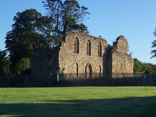 Kerelaw Castle 2006 | ||
| Staat | Vereinigtes Königreich | |
| Ort | Stevenston | |
| Entstehungszeit | um 1191, wieder aufgebaut nach 1488 | |
| Burgentyp | Niederungsburg | |
| Erhaltungszustand | Ruine | |
| Ständische Stellung | Schottischer Adel | |
| Bauweise | Bruchstein | |
| Geographische Lage | 55° 39′ N, 4° 45′ W | |
| Höhenlage | 19 m ASL | |
| ||

Kerelaw Castle ist eine Burgruine in Stadt Stevenston in der der schottischen Verwaltungseinheit North Ayrshire.
Geschichte
[Bearbeiten | Quelltext bearbeiten]Die Burg, die auch Kerila Castle oder Turnlaw Castle genannt wurde,[1][2] soll laut Timothy Pont ab 1191 von Richard de Morville für die Lockharts gehalten worden sein,[3] nachdem Stephen Lockhart (oder Loccard)[4] ein Stück Land in Ayrshire zugesprochen bekam. Dieses Land nannte er „Stevenstoune“ (später „Stevenston“) nach sich selbst und das Herrenhaus des Baronats Stevenston nannte man „Kerelaw“.[5] Burg und Baronat wurden später an die Campbells von Loudoun und noch später an die Cunninghames (oder Cunninghams, bzw. Cuninghames) von Kilmaurs übertragen. Während sich die Burg in den Händen der Cunninghames befand, wurde sie 1488 im Zuge der gut belegten, lang andauernden Fehde zwischen diesen beiden prominenten Familien aus Ayrshire von Hugh Montgomerie, 1. Earl of Eglinton, geplündert und niedergebrannt.[6] Die Cunninghames brannten unter der Führung des Earls of Glencairn 1528 Eglinton Castle als Rache bis auf die Grundmauern nieder.[7]

Kerelaw Castle wurde irgendwann nach 1488 wieder aufgebaut und soll eine Reihe geschnitzter Wappenschilder des schottischen Adels enthalten haben, die man von der Kilwinning Abbey genommen hatte.[9] Neun Fischern der Saltcoats wurde 1545 Land gegen den Transport der Möbel des Earls vom Bach der Saltcoats auf dem Clyde nach Finlayston jedes Frühjahr und den Rücktransport jeden Herbst, wenn die Familie für die Wintermonate auf Kerelaw Castle zurückkehrte, Land verpachtet. Ein halbes Fass Heringe musste ebenfalls jährlich dem Earl geliefert werden.[10]
Wohnsitz der Äbte
[Bearbeiten | Quelltext bearbeiten]Laut einer örtlichen Legende soll die Burg der Sitz des Abtes von Kilwinning gewesen sein, was möglicherweise auf die Tatsache zurückzuführen ist, dass der dritte Sohn von Alexander Cunningham, 1. Earl of Glencairn, nach der Reformation abwesender Abt der Abtei war und auf Kerelaw Castle gewohnt haben könnte.

Spätere Geschichte
[Bearbeiten | Quelltext bearbeiten]
1609 kaufte Sir Thomas Boyd das Anwesen und verkaufte es bald an Sir William Cunninghame aus Cunninghamhead weiter. 30 Jahre später kaufte Sir Robert Cunninghame aus Auchenharvie die Burg und die umgebenden Ländereien. 1655 kaufte John Hamilton aus Cambuskeith (heute „The Mount“), später aus Grange, (Großvater von Alexander Hamilton, einem Gründungsvater der USA) Kerelaw Castle und benannte es ist „Grange Castle“ nach seinem Familienhaus in Kilmarnock um. Clements und Graham geben das Jahr 1685 als Datum für den Verkauf von „Kerila“ (Kerelaw) an John Hamilton an.[12][13] Bis 1787 war die Burg der Sitz der Familie Hamilton; dann ließ ein weiterer Alexander Hamilton (Vetter 2. Grades des US-amerikanischen Politikers) Kerelaw House (auch „Grange House“) in der Nähe erbauen. Die Burg wurde bald aufgegeben.[14]
Den Grundstein des neuen Eglinton Castle in Kilwinning ließ Alexander Hamilton of Grange 1797 für den 12. Earl of Eglinton legen.[15]

Nebengebäude
[Bearbeiten | Quelltext bearbeiten]
Ein Taubenhaus von 1775 gab es hier[16] bis in die 1960er-Jahre; dann wurde es zusammen mit den anderen Nebengebäuden abgerissen. Im Burghof waren Häuser für die Arbeiter errichtet worden und ihre hohen Staffelgiebelenden ließen die Burgruine noch pittoresker erscheinen.[17] Die gotischen Fenster wurden vermutlich im 19. Jahrhundert in die Gebäude eingesetzt.[18] In der Nähe gab es auch einen Kalkofen. Dudups („Diddup“) in der Nähe war Teil des Anwesens.[19]
Roys Karte von 1747 verzeichnet den Namen als „Kerry-law“,[20] und Smith nennt die Burg „Kerila Castle“,[21] ebenso wie Paterson.[8] „Kyryaw Castle“, Mains und Mühle sind auf Ponts Landkarte von 1604–1608 verzeichnet. Eine Lodge östlich der Burg sieht man auf einer älteren Ordnance-Survey-Karte; sie existiert heute noch als Privathaus.
Spätere Geschichte
[Bearbeiten | Quelltext bearbeiten]Haus, Burg und Anwesen wurden 1838, nach Alexander Hamiltons Tod, an Gavin Fullerton verkauft. Fullerton nannte das Anwesen bald wieder „Kerelaw“.
Die Burg heute
[Bearbeiten | Quelltext bearbeiten]

Kerelaw Castle ist heute eine Ruine; drei Mauern sind in unterschiedlichen Stadien des Verfalls erhalten geblieben. Gotische Fenster schmücken immer noch die Südmauer; sie sollen von der Kilwinning Abbey beeinflusst worden sein (und beweisen, dass ein Großteil der Burg zu unterschiedlichen Zeiten entstand).
1852 verzeichnete Paterson Schießscharten und verseilte Verzierungen aus der Zeit vor dem 14. Jahrhundert.[22] Eine alte Brücke, die heute nur noch von Fußgängern benutzt wird, liegt in der Nähe der Ruine, aber die Burg selbst ist von einem Zaun umgeben, um Burgruine und Öffentlichkeit voreinander zu schützen (die Burgruine vor ungebetenem Besuch und die Öffentlichkeit von herabstürzenden Mauerteilen). Burgruine und Anwesen gehören der Gebietsverwaltung von North Ayrshire. 2014 wurden Reparaturarbeiten am Gebäude durchgeführt und die unmittelbare Umgebung wurde von Bewuchs befreit, der die Gebäude beschädigen und verdecken könnte. Am Zaun sind Schilder zur Erklärung der Burgruine angebracht.
Die Brücke hat eine große Höhlung, die Fußgängern einst den Zugang zum Weg entlang des Stevenston Burn ermöglichte.[23] Der Brückenbogen und die Höhlung zeigen, dass die Brücke in zwei Bauabschnitten errichtet und später verbreitert wurde; der bachaufwärts gerichtete Teil der Brücke ist späteren Datums. Ein großer, schön behauener Vierpass ist vom Brückenbogen abgefallen und liegt jetzt bachabwärts der Brücke.
Der frühere eingefriedete Garten der Burg mit seinen Sonnenuhren und der komplexen Beetanlage wurde Ende der 1960er-Jahre als Bauland genutzt, aber eine einzelne Mauer der Anlage ist noch erhalten. In einer Ordnance-Survey-Karte aus den 1850er-Jahren ist ein Obsthain verzeichnet, der in der Nähe des eingefriedeten Gartens lag.
Eine mit großen Steinen ausgelegte Furt kreuzte einst den Stevenston Burn im Kerelaw-Tal unterhalb der Burg. Der Weg führte das Ufer hinauf und am Bauernhaus von Kerelaw Mains vorbei. Bei der Anlage eines Kalksteinbruches wurde der Weg von der Furt herauf zerstört. Zwei Fußgängerbrücken führten über den Bach, eine am heute noch erhaltenen Wehr und die andere jenseits des Steinbruchhauses, wo heute noch vermörtelte, mit Werkstein verkleidete Steinmauern zu sehen sind.[24]
Bildergalerie der Burg und ihrer Umgebung
[Bearbeiten | Quelltext bearbeiten]-
Eines der bis heute erhaltenen, gotischen Fenster 2008
-
Die letzten Überreste des eingefriedeten Gartens der Burg 2008
-
Ein zugemauerter Eingang zum früheren eingefriedeten Garten 2008
-
Die Überreste der östlichen Burgmauer 2006
-
Überreste der alten Furt
-
Das Wehr am Stevenston Burn im Kerelaw-Tal


Einzelnachweise
[Bearbeiten | Quelltext bearbeiten]- ↑ William Robertson: Ayrshire: Its History and Historic Families. Band I. Dunlop & Drennan, Kilmarnock 1908. S. 133.
- ↑ a b James Clements: Stevenston (Stivenstoune Stinstin): The Kernel of Cunninghame. Gilmour and Lawrence, Glasgow 1974. S, 17.
- ↑ J. S. Dobie (Hrsg.): Cuninghame, Topographized by Timothy Pont, A M, 1604–1608: With Connotations and Illustrative Notices by the Late James Dobie of Crummock, FSA Scot. John Tweed, Glasgow 1876. S. 252–253.
- ↑ John Macintosh: Ayrshire Nights Entertainments. Dunlop & Drennan, Kilmarnock 1894. S. 329.
- ↑ J. S. Dobie (Hrsg.): Cuninghame, Topographized by Timothy Pont, A M, 1604–1608: With Connotations and Illustrative Notices by the Late James Dobie of Crummock, FSA Scot. John Tweed, Glasgow 1876. S. 370.
- ↑ William Robertson: Historical Tales and Legends of Ayrshire. Band II. Hamilton, Adams & Co., London 1889. S. 15–16.
- ↑ William Robertson: Historical Tales and Legends of Ayrshire. Band II. Hamilton, Adams & Co., London 1889. S. 13–29.
- ↑ a b James Paterson: History of the Counties of Ayr and Wigton. Band 5. James Stillie, Edinburgh 1863–1866. S. 561.
- ↑ Robert W. Billings: The Baronial and Ecclesiastical Antiquities of Scotland. Band III. Oliver & Boyd, Edinburgh 1901. S. 41.
- ↑ James Paterson: History of the Counties of Ayr and Wigton. Band 5. James Stillie, Edinburgh 1863–1866. S. 558.
- ↑ William Robertson: Historical Tales and Legends of Ayrshire. Band II. Hamilton, Adams & Co., London 1889. Tafel 6.
- ↑ James Clements: Stevenston (Stivenstoune Stinstin): The Kernel of Cunninghame. Gilmour and Lawrence, Glasgow 1974. S, 13.
- ↑ Eric J. Graham: Robert Reid Cunninghame of Seabank House. Ayr Archaeological and Natural Historical Society, Ayr 1997. S. 44.
- ↑ John Macintosh: Ayrshire Nights Entertainments. Dunlop & Drennan, Kilmarnock 1894. S. 330.
- ↑ Grand Tournament at Eglinton Castle. Kilwinning Heritage. Abgerufen am 28. September 2017.
- ↑ a b David McGibbon, Thomas Ross: The Castallated and Domestic Architecture of Scotland from the Twelfth to the Eighteenth Centuries. Band V. C. Douglas, Edinburgh 1887–1892. S. 569.
- ↑ Kerelaw House. Ayrshire Roots. Abgerufen am 28. September 2017.
- ↑ Michael Davis: The Castles and Mansions of Ayrshire. M. C. Davis, Ardrishaig, Argyll 1991. S. 292.
- ↑ J. S. Dobie (Hrsg.): Cuninghame, Topographized by Timothy Pont, A M, 1604–1608: With Connotations and Illustrative Notices by the Late James Dobie of Crummock, FSA Scot. John Tweed, Glasgow 1876. S. 124.
- ↑ Roy Military Survey of Scotland, 1747–55. National Library of Scotland, abgerufen am 28. September 2017.
- ↑ John Smith: Prehistoric Men in Ayrshire. E. Stock, London 1895. S. 54.
- ↑ James Paterson: History of the Counties of Ayr and Wigton. Band 2. James Stillie, Edinburgh 1863–1866. S. 445.
- ↑ Artists – Robert Bryden. FutureMuseum.co.uk, South West Scotland, abgerufen am 29. September 2017.
- ↑ Ayrshire, Sheet XVI (includes Ardrossan; Irvine; Kilwinning; Stevenston). Survey Date: 1856. Publication Date: 1860. Ordnance Survey Scotland, abgerufen am 29. September 2017.