Central Jersey: Difference between revisions
No edit summary |
m Reverted 1 edit by 184.81.1.45 (talk) identified as vandalism to last revision by Djflem. (TW) |
||
| Line 1: | Line 1: | ||
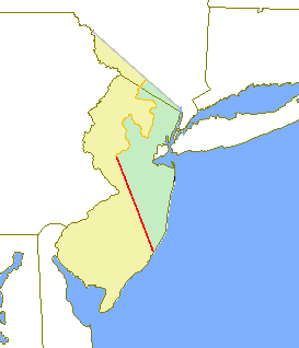
[[File:Central Jersey Counties.svg|right|thumb|Map highlighting the counties included in the broadest definition of Central Jersey are shown in green, with [[Ocean County, New Jersey|Ocean County]] in light green]] |
[[File:Central Jersey Counties.svg|right|thumb|Map highlighting the counties included in the broadest definition of Central Jersey are shown in green, with [[Ocean County, New Jersey|Ocean County]] in light green]] |
||
'''Central Jersey''' is |
'''Central Jersey''' is a region in the middle section of state of [[New Jersey]] in the [[United States of America]]. |
||
==Geography== |
==Geography== |
||
Revision as of 23:13, 11 December 2012

Central Jersey is a region in the middle section of state of New Jersey in the United States of America.
Geography
Lacking any official definition, there are varying descriptions as to what comprises Central Jersey. All tend to include Middlessex and the region radiating from New Brunswick including much of Monmouth, Mercer, and Somerset counties. Inclusion of adjacent areas of Hunterdon, Union, and Ocean counties is subjective and a source of debate.[1][2][3][4]
New Jersey's geographic center is located in Hamilton Township The population center of the state is alongside Nenninger Lane in the western portion of East Brunswick Township[5] which is also known as the 'Heart of Middlesex County".
Overlapping areas and definitions
There are other related, overlapping areas that include counties in the midsection of the state.
North Jersey and South Jersey are the northern and southern halves of New Jersey. While there is agreement that their border is somewhere in the middle third of the state, there is no official definition.[1]
While the region is considered part of the New York metropolitan area in its greatest extent, Mercer County constitutes a separate Metropolitan Statistical Area. The Metropolitan Statistical Areas of New Jersey further subdivides the middle third of the state into smaller groups of counties.
The New Jersey Department of Tourism places Middlesex and Union in the Gateway Region and Mercer in the Delaware Valley. Monmouth and Ocean are considered part of the Jersey Shore, while Somerset and Hunterdon are part of Skylands Region.[6]
The Raritan Valley is the region along the middle reaches of the Raritan River, and its North Branch and South Branch. Branchburg, Bridgewater, Somerville, Raritan, Green Brook, North Plainfield, Bound Brook, and South Bound Brook, which are all in Somerset, and Piscataway, South Plainfield, New Brunswick, Highland Park, Edison, Middlesex, Dunellen, and Metuchen, which are all in the northern and central portions of Middlesex County, New Jersey and Plainfield in southwestern Union County. Raritan Valley is also arguably one of the most affluent and ideal areas to live in New Jersey due to its location being roughly equidistant between New York City and Philadelphia.[7][8][9][10][11]
The Raritan Bayshore is used to describe the region in Monmouth County along the coast of the Raritan Bay from South Amboy to Sandy Hook.[12]
Kingston is the only tri-county community in New Jersey.[13]
Colonial era
Between 1674 and 1702, in the early part of New Jersey's colonial period, the border between West Jersey and East Jersey ran diagonally across the middle part of the state. The borders remained important in determining ownership and political boundaries until 1745. Remnants of that division are seen today, notably as the Hunterdon-Somerset, Ocean-Burlington, and Monmouth-Burlington county lines.[14] The Keith Line, as the demarcation is known, ran through the center of what is now Mercer.[15]
New Jersey position's between the major cities of New York and Philadelphia led Benjamin Franklin to call the state "a barrel tapped at both ends".[16][17] Travel between the two cities originally included a ferry crossing. Due to the obstacles created by the Meadowlands and the Hudson Palisades passengers from New York would cross the North River (Hudson River) and the Upper New York Bay by boat and then transfer to stagecoaches to travel overland through what is now Central Jersey. One route from Elizabethtown to Lambertville was known as Old York Road. Another route, from Perth Amboy through Kingston to Burlington ran along a portion of the Kings Highway, These roads followed Lenape paths known respectively as the Naritcong Trail and the Assunpink Trail.
Raritan Landing, across from New Brunswick in today's Piscataway became was important inland port and commercial hub for the region.[18] Two of the nine Colonial Colleges, founded before the American Revolution, were the College of New Jersey (now Princeton), and Queens College, (now Rutgers).
Media markets and national sports
Depending on the location, different parts of Central Jersey fall into overlapping spheres of influence from New York media market and Philadelphia media market. While the Star-Ledger has the largest circulation of all newspapers in New Jersey, four regional newspapers - Asbury Park Press, Home News Tribune and two Trenton dailies, The Trentonian, and The Times- and several local papers are published in Central Jersey. New Jersey On-Line, CentralJersey.com and MyCentralJersey.com are web based news services. During statewide political events like Gubernatorial or Senatorial election debates often held in Trenton, partner stations from both the New York and Philadelphia markets pool resources together to co-host the events and bring them to New Jersey homes.
Identification with sports teams is also affected by the region's location, and it is not uncommon to find fans of major sports teams of either city. For example, while residents of northern New Jersey tend to favor the New York Giants who play at Met Life Stadium, those in the southern part of the state are Philadelphia Eagles fans. The distinction is less clear in Central Jersey. Central Jersey Riptide was a short-lived professional soccer club.[19]
Transportation

Apart from Mercer County, which comes under the auspices of the Delaware Valley Regional Planning Commission, all counties in the region are part of the North Jersey Transportation Planning Authority, a government partner which approves transportation projects for the state.
The United New Jersey Railroad and Canal Company traversed the region in 1830, evetually becoming the Pennsylvania Railroad (PRR). NJT's Northeast Corridor Line and the North Jersey Coast were once part of the PRR, as was Amtrak which serves the commuter hub at Metropark, New Brunswick, and the Trenton Transit Center. The Central Railroad of New Jersey once connected Jersey City (with connecting ferries to Manhattan) and many Central Jersey towns. Much of that system is now included in New Jersey Transit rail operations to the Raritan Valley.
The Garden State Parkway, New Jersey Turnpike (Interstate 95), Interstate 287, U.S. Route 1, U.S. Route 9, New Jersey Route 18, and New Jersey Route 35 are major automobile routes through Central Jersey that pass over the Raritan River at Perth Amboy and New Brunswick. Interstate 195 travels through Central Jersey (hence the name "Central Jersey Expressway") from the Trenton area towards Belmar.
From the Raritan Bayshore, SeaStreak catamarans travel to Pier 11 at Wall Street and East 34th Street Ferry Landing. NY Waterway ferries travel to Paulus Hook Ferry Terminal in Jersey City, Battery Park City Ferry Terminal and West Midtown Ferry Terminal.
Newark Airport is the nearest airport providing long-distance commercial service. Monmouth Executive Airport, formerly known as Allaire Airport, is a public-use airport located near Allaire State Park. Central Jersey Regional Airport is a privately owned, public airport in Somerset County. Linden Airport is a small general aviation airport located along U.S. Route 1&9 in Union County,
The Route 9 BBS, the New Brunswick BRT, and the Central Jersey Route 1 Corridor are projects in the region that would expand the use of bus rapid transit in New Jersey.
Economy

All of the region's counties are ranked among the highest income counties in the United States, as measured by median household income.[20] It has been called the state's "wealth belt".[21]
Telecommunications
The Bell Labs Holmdel Complex was the site of many innovations in telecommunications. Today Verizon Wireless, AT&T Communications, Vonage, Avaya, and Bell Labs are located in the region.
Healthcare and pharmaceuticals
New Brunswick is known as "the Healthcare City",[22][23] due to the concentration of medical facilities in Central Jersey, including Robert Wood Johnson University Hospital and Saint Peter's University Hospital, as well as the University of Medicine and Dentistry of New Jersey (UMDNJ)-Robert Wood Johnson Medical School. The campuses of the major pharmaceutical corporations Bristol-Myers Squibb Company, Johnson and Johnson, Schering-Plough, Merck and Sanofi-Aventis are located in the region. Princeton University's Frist Campus Center[a] is used for the aerial views of Princeton‑Plainsboro Teaching Hospital seen in the television series House[24]
Shopping malls
Major shopping centers include Woodbridge Center, Menlo Park Mall, Bridgewater Commons, Monmouth Mall, Brunswick Square Mall, Quaker Bridge Mall, Princeton Market Fair and Freehold Raceway Mall.
Academia
Monmouth University, Rutgers University, Princeton University, Rider University, New Brunswick Theological Seminary, and The College of New Jersey are located in Central Jersey. Each county maintains a county college, with the Raritan Valley Community College serving both Somerset and Hunterdon. Kean University is in Union County,
Tourism and cultural attractions
Popular tourist attractions include, Six Flags Great Adventure, Gateway National Recreation Area, Monmouth Park Racetrack, Freehold Raceway and the boardwalk along the northern Jersey Shore
The New Brunswick music scene has produced many successful indie bands. In an early era, the Stone Pony and Asbury Park Convention Hall were important venues on the rock scene. Major music and theater venues in the region include PNC Bank Arts Center, the Trenton War Memorial, the McCarter Theater, the Count Basie Theater, and the George Street Playhouse.
Road Up Raritan Historic District, as well as those in Trenton, Princeton recall the colonial era. Ocean Grove is one of the largest national historical sites in the United States.
Notable Central Jerseyans
- People from Hunterdon County
- People from Mercer County
- People from Middlesex County
- People from Monmouth County
- People from Ocean County
- People from Somerset County
- People from Union County
See also
References
- ^ a b Jean Mikle (March 31, 2008). "An invisible boundary divides N.J." Home News Tribune. Retrieved January 12, 2010.
{{cite news}}: Italic or bold markup not allowed in:|publisher=(help)("Of course, part of the problem with understanding New Jersey's enduring regional tension is that few residents can agree on where the northern half of the state ends and the southern half begins.") - ^ North Versus South, Jersey Style A shared sense of place hard to find in the Garden State (PDF), Monmouth University Polling Institute, March 8, 2008
- ^ Spivey, Mark (January 30, 2012), "Central Jersey (which doesn't exist): Hard to define, easy to love Online debate persists over where, what it is", Asbury Park Press, retrieved 2012-02-05
- ^ Hiembuch, Jeff (May 19, 2009), "North Vs South Vs Central - Where Do YOU Live?", nj.com, retrieved 2012-02-05
- ^ Stirling, Stephen (March 31, 2011). "U.S. Census shows East Brunswick as statistical center of N.J." The Star-Ledger. Retrieved 2012-11-07.
if all 8.8 million residents of the state were to stand on a giant table supported by a single leg, Nenninger Lane would be the fulcrum point keeping it balanced
- ^ "Visitor Information - Regional Tourism". Archived from the original on 2011-02-03.
{{cite web}}: Unknown parameter|deadurl=ignored (|url-status=suggested) (help) - ^ http://www.optimum.com/lineup.jsp?regionId=38 Optimum Online Television Service. Channel lineup for the Raritan Valley region, consisting of, "Bridgewater, Edison, North Brunswick, Old Bridge, Piscataway"
- ^ http://www.njtransit.com/pdf/rail/r0060.pdf Raritan Valley Line operated by NJ Transit. Covers Hunterdon, Somerset, Middlesex and Union counties
- ^ http://www.raritanval.edu/ Raritan Valley Community College in North Branch
- ^ http://www.scarletknights.com/crew/camp/camp.asp Raritan Valley Rowing Camp. A program sponsored by Rutgers University in New Brunswick.
- ^ http://www.raritanvalleyconference.com/index.php Raritan Valley Conference. A Pop Warner league covering Somerset and Middlesex Counties.
- ^ Bowes, Karen E. (August 30, 2006). "Blueprint complete for improved Rt. 36: County to vote on Bayshore Regional Strategic Plan". Holmdel Independent. Retrieved 2012-02-10.
- ^ Muser, Jeanette K. "Kingston: Crossroads To History". Kingstongreenways. Retrieved 2008-07-17.
Although the community remains unincorporated today, residents share a common heritage that goes back to the 17th century. What makes Kingston so unique, however, is that it is the only tri-county community in New Jersey.
- ^ http://westjersey.org/wj_line.htm
- ^ "A Brief History of Princeton Early Roads And Boundries [sic]". Historic Preservation in Princeton Township. Princeton Township. Retrieved 2012-02-15.
- ^ Fairall, Herbert (1885). The World's Industrial and Cotton Centennial Exposition, New Orleans, 1884-1885. p. 225. Google Book Search. Retrieved on December 4, 2009. "Dr. Benjamin Franklin once perpetrated the witticism 'that New Jersey was like a beer barrel tapped at both ends, with all the live beer running into Philadelphia and New York.'"
- ^ http://www.jstor.org/pss/30030707
- ^ "Recovering Raritan Landing The Archeology of a Forgotten Town". New Jersey Department of Transportation. 2002. Retrieved 2011-07-05.
{{cite web}}: Cite has empty unknown parameter:|coauthors=(help) - ^ Gale, Dennis E. (2006), Greater New Jersey Living in the Shadow of Gotham, University of Pennsylvania Press, ISBN 978-0-8122-1957-9
- ^ 250 Highest Per Capita Personal Incomes of the 3111 Counties in the United States, 2006, Bureau of Economic Analysis. Accessed May 2, 2008.
- ^ http://www.nytimes.com/1999/09/26/realestate/in-the-region-new-jersey-living-large-in-the-state-s-new-wealth-belt.html?pagewanted=all&src=pm
- ^ 7:30 a.m. -- Filling cracks in the HealthCare City, from the Home News Tribune, September 23, 1999. "With two major hospitals and a medical school, New Brunswick proclaims itself The Healthcare City."
- ^ A wet day in the Hub City, Home News Tribune, September 23, 1999. "A few days short of 60 years, on Wednesday, Sept. 16, a dreary, drizzly day just ahead of the deluge of Hurricane Floyd, the Home News Tribune sent 24 reporters, 9 photographers and one artist into the Hub City, as it is known, to take a peek into life in New Brunswick as it is in 1999."
- ^ Holtz, Andrew (2006). The Medical Science of House, M.D. Berkley Trade. doi:10.1097/01.COT.0000295295.97642.ae. ISBN 0-425-21230-0. Retrieved June 19, 2009.