Central United States: Difference between revisions
No edit summary |
Duckmather (talk | contribs) add section header |
||
| (24 intermediate revisions by 20 users not shown) | |||
| Line 1: | Line 1: | ||
{{Short description|Geographical region of the |
{{Short description|Geographical region of the United States}} |
||
{{ |
{{Distinguish|Central America|Geographic center of the United States}} |
||
| ⚫ | |||
{{ |
{{More citations needed|date=November 2009}} |
||
| ⚫ | |||
[[File:Pass over Canada and Central United States at Night.ogv|thumb|300px|This video was taken by the crew of [[Expedition 29]] on board the [[International Space Station|ISS]]. The pass begins over Canada and ends in the [[Caribbean Sea]], covering the entire Central United States.]] |
[[File:Pass over Canada and Central United States at Night.ogv|thumb|300px|This video was taken by the crew of [[Expedition 29]] on board the [[International Space Station|ISS]]. The pass begins over Canada and ends in the [[Caribbean Sea]], covering the entire Central United States.]] |
||
The '''Central United States''' is sometimes conceived as between the [[Eastern United States|Eastern]] and [[Western United States|Western]] as part of a three-region model, roughly coincident with the [[United States Census Bureau|U.S. Census']] definition of the [[Midwestern United States]] plus the western and central portions of the U.S. Census' definition of the [[Southern United States]]. The Central States are typically considered to consist of [[North Dakota]], [[South Dakota]], [[Nebraska]], [[Kansas]], [[Oklahoma]], [[Texas]], [[Minnesota]], [[Iowa]], [[Missouri]], [[Arkansas]], [[Louisiana]], [[Wisconsin]], [[Illinois]], [[Michigan]], [[Indiana]], [[Ohio]], [[Kentucky]], [[Tennessee]], [[West Virginia]], [[Mississippi]] and [[Alabama]] |
The '''Central United States''' is sometimes conceived as between the [[Eastern United States|Eastern]] and [[Western United States|Western]] as part of a three-region model, roughly coincident with the [[United States Census Bureau|U.S. Census's]] definition of the [[Midwestern United States]] plus the western and central portions of the U.S. Census's definition of the [[Southern United States]]. The Central States are typically considered to consist of [[North Dakota]], [[South Dakota]], [[Nebraska]], [[Kansas]], [[Oklahoma]], [[Texas]], [[Minnesota]], [[Iowa]], [[Missouri]], [[Arkansas]], [[Louisiana]], [[Wisconsin]], [[Illinois]], [[Michigan]], [[Indiana]], [[Ohio]], [[Kentucky]], [[Tennessee]], [[West Virginia]], [[Mississippi]] and [[Alabama]].{{citation needed|date=February 2021}} |
||
== Geography == |
|||
[[Chicago]] is the area's largest city and metropolitan area; other large cities with large metropolitan areas include [[New Orleans]], [[Houston]], [[Dallas]], [[Fort Worth, Texas|Fort Worth]], [[San Antonio]], [[Austin, Texas|Austin]], [[Oklahoma City]], [[Tulsa, Oklahoma|Tulsa]], [[Kansas City, Kansas|Kansas City]], [[Kansas]] and [[Kansas City, Missouri|Kansas City]], [[Missouri]], [[Topeka, Kansas|Topeka]], [[Wichita, Kansas|Wichita]], [[Omaha, Nebraska]] and [[Lincoln, Nebraska|Lincoln]], [[Minneapolis]] and [[Saint Paul, Minnesota|St. Paul]], [[Madison, Wisconsin|Madison]] and [[Milwaukee]], [[St. Louis]], [[Louisville, Kentucky|Louisville]], [[Lexington, Kentucky|Lexington]], [[Detroit]], [[Cincinnati]], [[Cleveland]], [[Columbus, Ohio|Columbus]], [[Toledo, Ohio|Toledo]], [[Dayton, Ohio|Dayton]], [[Rockford, Illinois|Rockford]], [[Peoria, Illinois|Peoria]], [[Indianapolis]], [[Evansville, Indiana|Evansville]], [[Fort Wayne, Indiana|Fort Wayne]] and [[South Bend, Indiana|South Bend]].{{citation needed|date=February 2021}} |
|||
Four of nine [[List of regions of the United States#Census Bureau-designated regions and divisions|Census Bureau Divisions]] have names containing "Central", though they are not grouped as a region. They include 20 states and 39.45% of the U.S. population as of July 1, 2007.<ref>{{Cite web |url=https://www.census.gov |title=U.S. Census website<!-- Bot generated title --> |access-date=2008-05-20 }}</ref> |
|||
<!-- {| class="wikitable" |
<!-- {| class="wikitable" |
||
|- |
|- |
||
|} --> |
|} --> |
||
Almost all of the area is in the [[Gulf of Mexico]] [[drainage basin]] and most of that is in the [[Mississippi Basin]]. Small |
Almost all of the area is in the [[Gulf of Mexico]] [[drainage basin]] and most of that is in the [[Mississippi River#Watershed|Mississippi Basin]]. Small waterways near the Great Lakes drain into the [[Great Lakes]], and eventually the [[St. Lawrence River]]. The [[Red River Valley]] is centered on the [[North Dakota]]-[[Minnesota]] border and drains to [[Hudson Bay]]. Floods have been a problem for the region during the 20th and early 21st century.<ref>{{cite journal|title=The changing nature of flooding across the central United States|publisher=Nature|language=English|author=Iman Mallakpour & Gabriele Villarini|date=29 September 2014|volume=5|doi=10.1038/nclimate2516|journal=Nature Climate Change|issue=3 |pages=250–254}}</ref> |
||
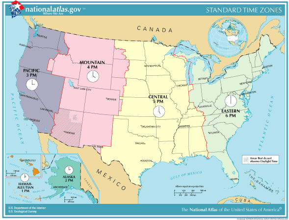
The [[Central Time Zone]] |
The [[Central Time Zone]] includes portions of the [[Florida Panhandle]], upper portions of [[Michigan]], parts of [[Indiana]], western [[Kentucky]], western [[Tennessee]], all of [[Texas]] except [[El Paso, Texas|El Paso]], and extends to the westernmost fringes of [[Great Plains]] states.{{citation needed|date=February 2021}} |
||
== Gallery == |
|||
Floods have been a problem for the region during the 20th and early-21st century.<ref>{{cite journal|title=The changing nature of flooding across the central United States|publisher=Nature|language=English|author=Iman Mallakpour & Gabriele Villarini|date=29 September 2014|volume=5|doi=10.1038/nclimate2516|journal=Nature Climate Change|pages=250–254}}</ref> |
|||
| ⚫ | |||
File:The Harmsworth atlas and Gazetter 1908 (135851662).jpg|Central United States in 1908 from ''The Harmsworth atlas and Gazetter'' |
|||
| ⚫ | |||
Image:US Census Central Divisions.svg|[[List of regions of the United States#Census Bureau-designated regions and divisions|Census Bureau Divisions]] with "Central" in their name. |
Image:US Census Central Divisions.svg|[[List of regions of the United States#Census Bureau-designated regions and divisions|Census Bureau Divisions]] with "Central" in their name include the [[West North Central states|West North Central]] and [[East North Central states|East North Central]] in the [[Midwestern United States|Midwest]]. Along with the [[West South Central states|West South Central]] and [[East South Central states|East South Central]] in the [[Southern United States|South]]. |
||
Image:National-atlas-timezones-2006.gif|Map of [[Time in the United States|U.S. time zones]] between April 2, 2006 and March 11, 2007. The current |
Image:National-atlas-timezones-2006.gif|Map of [[Time in the United States|U.S. time zones]] between April 2, 2006, and March 11, 2007. The current time zone now has [[Pulaski County, Indiana]] in the [[Eastern Time Zone]] and no longer in the [[Central Time Zone]]. |
||
Image:NorthAmerica-WaterDivides.png|[[Continental divide]]s in [[North America]]. |
Image:NorthAmerica-WaterDivides.png|[[Continental divide]]s in [[North America]]. |
||
</gallery> |
</gallery> |
||
==Central regions defined by organizations== |
== Central regions defined by organizations == |
||
Different organizations define the central regions of the United States in a variety of ways: |
Different organizations define the central regions of the United States in a variety of ways: |
||
*[https://archive.today/20140107052658/http://www.ypo.org/regions-and-chapters/united-states/central-u-s/ YPO] Only 6 central states of the Midwest,{{efn|See Census definition|name=Census}} plus KY |
*[https://archive.today/20140107052658/http://www.ypo.org/regions-and-chapters/united-states/central-u-s/ YPO] Only 6 central states of the Midwest,{{efn|See Census definition|name=Census}} plus KY |
||
*[http://webarchive.loc.gov/all/20020913041734/http://folkworm.ceri.memphis.edu/recenteqs/ CERI] All of Midwest and South{{efn|name=Census}} including MD, DE |
*[http://webarchive.loc.gov/all/20020913041734/http://folkworm.ceri.memphis.edu/recenteqs/ CERI] All of Midwest and South{{efn|name=Census}} including MD, DE |
||
| Line 36: | Line 37: | ||
*[http://www.adventure-camp.com/ Adventure Camp] Midwest plus South{{efn|name=Census}} minus Atlantic states, AL, WV |
*[http://www.adventure-camp.com/ Adventure Camp] Midwest plus South{{efn|name=Census}} minus Atlantic states, AL, WV |
||
*[[Geography of the Interior United States]] |
*[[Geography of the Interior United States]] |
||
*[[National League Central]] Division, members in PA, OH, WI, IL, MO; TX through 2012 |
*[[Major League Baseball|MLB]]'s [[National League Central]] Division, members in PA, OH, WI, IL, MO; TX through 2012 |
||
*[[American League Central]] Division, members in OH, MI, IL, MN, MO |
*MLB's [[American League Central]] Division, members in OH, MI, IL, MN, MO |
||
*National Basketball Association [[Central Division (NBA)|Central Division]], members in OH, MI, IN, IL, WI, former members from NC, FL, GA, LA and Ontario (Canada) |
*[[National Basketball Association|NBA]]'s [[Central Division (NBA)|Central Division]], members in OH, MI, IN, IL, WI, former members from NC, FL, GA, LA and Ontario (Canada) |
||
*National Hockey League [[Central Division (NHL)|Central Division]], members in CO, MN, TN, TX, IL, MO and Manitoba (Canada), former members in MI, AZ, OH and Ontario (Canada) |
*[[National Hockey League|NHL]]'s [[Central Division (NHL)|Central Division]], members in CO, MN, TN, TX, IL, MO and Manitoba (Canada), former members in MI, AZ, OH and Ontario (Canada) |
||
* |
*The [[National Football League|NFL]]'s former [[NFC North|National Football Conference Central Division]], members in FL, MI, IL, WI, and MN |
||
* |
*The NFL's former [[AFC North|American Football Conference Central Division]], members in MD, PA, FL, OH, TN, former member from TX |
||
== Geographic center of the United States == |
== Geographic center of the United States == |
||
The geographic midpoint of the contiguous 48 states of the United States falls within the boundaries of the Central United States and is located about two miles northwest of [[Lebanon, Kansas|Lebanon]], [[Kansas]]. The spot is located at 39 degrees 50 minutes latitude and 98 degrees 35 minutes longitude.<ref>{{Cite web|url=http://www.kansastravel.org/geographicalcenter.htm|title=Geographic Center of the United States|website=www.kansastravel.org|access-date=2020-03-24}}</ref> |
The geographic midpoint of the contiguous 48 states of the United States falls within the boundaries of the Central United States and is located about two miles northwest of [[Lebanon, Kansas|Lebanon]], [[Kansas]]. The spot is located at 39 degrees 50 minutes latitude and 98 degrees 35 minutes longitude.<ref>{{Cite web|url=http://www.kansastravel.org/geographicalcenter.htm|title=Geographic Center of the United States|website=www.kansastravel.org|access-date=2020-03-24}}</ref> |
||
== See also == |
== See also == |
||
* [[Central Canada]] |
* [[Central Canada]] |
||
| Line 52: | Line 54: | ||
== Notes == |
== Notes == |
||
{{notelist}} |
{{notelist}} |
||
== References == |
== References == |
||
Latest revision as of 00:50, 17 June 2024
This article needs additional citations for verification. (November 2009) |
The Central United States is sometimes conceived as between the Eastern and Western as part of a three-region model, roughly coincident with the U.S. Census's definition of the Midwestern United States plus the western and central portions of the U.S. Census's definition of the Southern United States. The Central States are typically considered to consist of North Dakota, South Dakota, Nebraska, Kansas, Oklahoma, Texas, Minnesota, Iowa, Missouri, Arkansas, Louisiana, Wisconsin, Illinois, Michigan, Indiana, Ohio, Kentucky, Tennessee, West Virginia, Mississippi and Alabama.[citation needed]
Geography[edit]
Chicago is the area's largest city and metropolitan area; other large cities with large metropolitan areas include New Orleans, Houston, Dallas, Fort Worth, San Antonio, Austin, Oklahoma City, Tulsa, Kansas City, Kansas and Kansas City, Missouri, Topeka, Wichita, Omaha, Nebraska and Lincoln, Minneapolis and St. Paul, Madison and Milwaukee, St. Louis, Louisville, Lexington, Detroit, Cincinnati, Cleveland, Columbus, Toledo, Dayton, Rockford, Peoria, Indianapolis, Evansville, Fort Wayne and South Bend.[citation needed]
Four of nine Census Bureau Divisions have names containing "Central", though they are not grouped as a region. They include 20 states and 39.45% of the U.S. population as of July 1, 2007.[1]
Almost all of the area is in the Gulf of Mexico drainage basin and most of that is in the Mississippi Basin. Small waterways near the Great Lakes drain into the Great Lakes, and eventually the St. Lawrence River. The Red River Valley is centered on the North Dakota-Minnesota border and drains to Hudson Bay. Floods have been a problem for the region during the 20th and early 21st century.[2]
The Central Time Zone includes portions of the Florida Panhandle, upper portions of Michigan, parts of Indiana, western Kentucky, western Tennessee, all of Texas except El Paso, and extends to the westernmost fringes of Great Plains states.[citation needed]
Gallery[edit]
-
Central United States in 1908 from The Harmsworth atlas and Gazetter
-
Census Bureau Divisions with "Central" in their name include the West North Central and East North Central in the Midwest. Along with the West South Central and East South Central in the South.
-
Map of U.S. time zones between April 2, 2006, and March 11, 2007. The current time zone now has Pulaski County, Indiana in the Eastern Time Zone and no longer in the Central Time Zone.
-


Central regions defined by organizations[edit]
Different organizations define the central regions of the United States in a variety of ways:
- YPO Only 6 central states of the Midwest,[a] plus KY
- CERI All of Midwest and South[a] including MD, DE
- NOAA Midwest[a] minus OH, plus KY, CO, WY
- HSUS Midwest[a] minus ND, SD, KS, plus KY
- USGS West North Central States, South Central United States, 4 eastern Mountain states
- Adventure Camp Midwest plus South[a] minus Atlantic states, AL, WV
- Geography of the Interior United States
- MLB's National League Central Division, members in PA, OH, WI, IL, MO; TX through 2012
- MLB's American League Central Division, members in OH, MI, IL, MN, MO
- NBA's Central Division, members in OH, MI, IN, IL, WI, former members from NC, FL, GA, LA and Ontario (Canada)
- NHL's Central Division, members in CO, MN, TN, TX, IL, MO and Manitoba (Canada), former members in MI, AZ, OH and Ontario (Canada)
- The NFL's former National Football Conference Central Division, members in FL, MI, IL, WI, and MN
- The NFL's former American Football Conference Central Division, members in MD, PA, FL, OH, TN, former member from TX
Geographic center of the United States[edit]
The geographic midpoint of the contiguous 48 states of the United States falls within the boundaries of the Central United States and is located about two miles northwest of Lebanon, Kansas. The spot is located at 39 degrees 50 minutes latitude and 98 degrees 35 minutes longitude.[3]
See also[edit]
Notes[edit]
References[edit]
- ^ "U.S. Census website". Retrieved 2008-05-20.
- ^ Iman Mallakpour & Gabriele Villarini (29 September 2014). "The changing nature of flooding across the central United States". Nature Climate Change. 5 (3). Nature: 250–254. doi:10.1038/nclimate2516.
- ^ "Geographic Center of the United States". www.kansastravel.org. Retrieved 2020-03-24.