Goudet: Difference between revisions
Content deleted Content added
No edit summary |
m Task 18 (cosmetic): eval 3 templates: del empty params (1×); hyphenate params (2×); cvt lang vals (1×); |
||
| Line 20: | Line 20: | ||
}} |
}} |
||
'''Goudet''' is a [[Communes of France|commune]] in the [[Haute-Loire]] [[Departments of France|department]] in south-central [[France]]. The village stands on the upper reaches of the [[Loire|River Loire]] and is overlooked by the [[Château de Beaufort]], built in the 13th century, of importance during the [[Hundred Years War]] and the [[French Wars of Religion]] but abandoned after the [[French Revolution|Revolution]] of 1789.<ref>{{cite web |url=http://www.culture.gouv.fr/public/mistral/merimee_fr?ACTION=CHERCHER&FIELD_1=INSEE&VALUE_1=43101 |publisher=Ministry of Culture |title=Château de Beaufort | |
'''Goudet''' is a [[Communes of France|commune]] in the [[Haute-Loire]] [[Departments of France|department]] in south-central [[France]]. The village stands on the upper reaches of the [[Loire|River Loire]] and is overlooked by the [[Château de Beaufort]], built in the 13th century, of importance during the [[Hundred Years War]] and the [[French Wars of Religion]] but abandoned after the [[French Revolution|Revolution]] of 1789.<ref>{{cite web |url=http://www.culture.gouv.fr/public/mistral/merimee_fr?ACTION=CHERCHER&FIELD_1=INSEE&VALUE_1=43101 |publisher=Ministry of Culture |title=Château de Beaufort |access-date=27 June 2017 |language=fr}}</ref> |
||
The [[GR 70|Robert Louis Stevenson Trail (GR 70)]], a popular long-distance path, runs through the village,<ref name="castle">{{cite book |title=The Robert Louis Stevenson Trail |publisher=Cicerone |edition=2nd |date=2007 |first=Alan |last=Castle |isbn=978-1-85284-511-7 |pages=65–67}}</ref> as do the GR3 and GR40.<ref>{{cite web |url=https://www.geoportail.gouv.fr/carte?c=3.9300048889160135,44.89218904163175&z=14&l0=GEOGRAPHICALGRIDSYSTEMS.MAPS.SCAN-EXPRESS.STANDARD::GEOPORTAIL:OGC:WMTS(1)&l1=GEOGRAPHICALGRIDSYSTEMS.MAPS::GEOPORTAIL:OGC:WMTS(1)&permalink=yes |title=Géoportail |publisher=IGN |date |
The [[GR 70|Robert Louis Stevenson Trail (GR 70)]], a popular long-distance path, runs through the village,<ref name="castle">{{cite book |title=The Robert Louis Stevenson Trail |publisher=Cicerone |edition=2nd |date=2007 |first=Alan |last=Castle |isbn=978-1-85284-511-7 |pages=65–67}}</ref> as do the GR3 and GR40.<ref>{{cite web |url=https://www.geoportail.gouv.fr/carte?c=3.9300048889160135,44.89218904163175&z=14&l0=GEOGRAPHICALGRIDSYSTEMS.MAPS.SCAN-EXPRESS.STANDARD::GEOPORTAIL:OGC:WMTS(1)&l1=GEOGRAPHICALGRIDSYSTEMS.MAPS::GEOPORTAIL:OGC:WMTS(1)&permalink=yes |title=Géoportail |publisher=IGN |access-date=27 June 2017}}</ref> |
||
==Population== |
==Population== |
||
Revision as of 04:09, 15 December 2020
Goudet | |
|---|---|
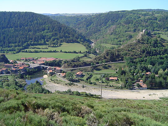 The Loire and the Château de Beaufort | |
Location of Goudet  | |
 Goudet  Goudet | |
| Coordinates: 44°53′24″N 3°55′35″E / 44.89°N 3.9264°E | |
| Country | France |
| Region | Auvergne-Rhône-Alpes |
| Department | Haute-Loire |
| Arrondissement | Le Puy-en-Velay |
| Canton | Mézenc |
| Government | |
| • Mayor (2014–2020) | Joël Lacour |
| Area 1 | 4.5 km2 (1.7 sq mi) |
| Population (2021)[1] | 66 |
| • Density | 15/km2 (38/sq mi) |
| Time zone | UTC+01:00 (CET) |
| • Summer (DST) | UTC+02:00 (CEST) |
| INSEE/Postal code | 43101 /43150 |
| Elevation | 733–1,018 m (2,405–3,340 ft) (avg. 770 m or 2,530 ft) |
| 1 French Land Register data, which excludes lakes, ponds, glaciers > 1 km2 (0.386 sq mi or 247 acres) and river estuaries. | |
Goudet is a commune in the Haute-Loire department in south-central France. The village stands on the upper reaches of the River Loire and is overlooked by the Château de Beaufort, built in the 13th century, of importance during the Hundred Years War and the French Wars of Religion but abandoned after the Revolution of 1789.[2]
The Robert Louis Stevenson Trail (GR 70), a popular long-distance path, runs through the village,[3] as do the GR3 and GR40.[4]
Population
| Year | Pop. | ±% |
|---|---|---|
| 1793 | 443 | — |
| 1806 | 582 | +31.4% |
| 1821 | 540 | −7.2% |
| 1831 | 563 | +4.3% |
| 1841 | 513 | −8.9% |
| 1851 | 542 | +5.7% |
| 1861 | 548 | +1.1% |
| 1872 | 549 | +0.2% |
| 1881 | 510 | −7.1% |
| 1891 | 506 | −0.8% |
| 1901 | 485 | −4.2% |
| 1911 | 367 | −24.3% |
| 1921 | 285 | −22.3% |
| 1931 | 258 | −9.5% |
| 1946 | 155 | −39.9% |
| 1954 | 145 | −6.5% |
| 1962 | 103 | −29.0% |
| 1968 | 92 | −10.7% |
| 1975 | 82 | −10.9% |
| 1982 | 80 | −2.4% |
| 1990 | 65 | −18.8% |
| 1999 | 63 | −3.1% |
| 2012 | 56 | −11.1% |
| 2017 | 60 | +7.1% |
See also
References
- ^ "Populations légales 2021" (in French). The National Institute of Statistics and Economic Studies. 28 December 2023.
- ^ "Château de Beaufort" (in French). Ministry of Culture. Retrieved 27 June 2017.
- ^ Castle, Alan (2007). The Robert Louis Stevenson Trail (2nd ed.). Cicerone. pp. 65–67. ISBN 978-1-85284-511-7.
- ^ "Géoportail". IGN. Retrieved 27 June 2017.
Wikimedia Commons has media related to Goudet.
| International | |
|---|---|
| National | |
This Haute-Loire geographical article is a stub. You can help Wikipedia by expanding it. |