Goudet: Difference between revisions
Content deleted Content added
ibx param |
population update, reference |
||
| (15 intermediate revisions by 8 users not shown) | |||
| Line 1: | Line 1: | ||
{{Use dmy dates|date=August 2023}} |
|||
{{Infobox French commune |
{{Infobox French commune |
||
|name = Goudet |
|name = Goudet |
||
|commune status = [[Communes of France|Commune]] |
|commune status = [[Communes of France|Commune]] |
||
|image = Goudet, la Loire et le château de Beaufort.JPG |
|image = Goudet, la Loire et le château de Beaufort.JPG |
||
|caption = The [[Loire]] and the Château de Beaufort |
|caption = The [[Loire]] and the ''Château de Beaufort'' |
||
|image coat of arms = |
|||
|region = Auvergne |
|||
|department = Haute-Loire |
|||
|arrondissement = Le Puy-en-Velay |
|arrondissement = Le Puy-en-Velay |
||
|canton = |
|canton = Mézenc |
||
|mayor = Jean-Claude Massebeuf<ref>{{cite web|title=Répertoire national des élus: les maires|url=https://www.data.gouv.fr/fr/datasets/r/2876a346-d50c-4911-934e-19ee07b0e503|publisher=data.gouv.fr, Plateforme ouverte des données publiques françaises|date=6 June 2023|language=fr}}</ref> |
|||
|mayor = Marc Piguet |
|||
|term = |
|term = 2023–2026 |
||
|coordinates = {{coord|44.89|3.9264|format=dms|display=inline,title}} |
|coordinates = {{coord|44.89|3.9264|format=dms|display=inline,title}} |
||
|elevation m = 770 |
|elevation m = 770 |
||
| Line 16: | Line 14: | ||
|elevation max m = 1018 |
|elevation max m = 1018 |
||
|area km2 = 4.5 |
|area km2 = 4.5 |
||
|population = |
|population = {{France metadata Wikidata|population_total}} |
||
|population date = |
|population date = {{France metadata Wikidata|population_as_of}} |
||
|population footnotes = {{France metadata Wikidata|population_footnotes}} |
|||
|INSEE = 43101 |
|INSEE = 43101 |
||
|postal code = 43150 |
|postal code = 43150 |
||
}} |
}} |
||
'''Goudet''' is a [[Communes of France|commune]] in the [[Haute-Loire]] [[Departments of France|department]] in south-central [[France]]. |
'''Goudet''' ({{IPA-fr|ɡudɛ}}) is a [[Communes of France|commune]] in the [[Haute-Loire]] [[Departments of France|department]] in south-central [[France]]. The village stands on the upper reaches of the river [[Loire]] and is overlooked by the [[Château de Beaufort]], built in the 13th century, of importance during the [[Hundred Years War]] and the [[French Wars of Religion]] but abandoned after the [[French Revolution|Revolution]] of 1789.<ref>{{Base Mérimée|PA00132734|Château de Beaufort}}</ref> |
||
The [[GR 70|Robert Louis Stevenson Trail (GR 70)]], a popular long-distance path, runs through the village,<ref name="castle">{{cite book |title=The Robert Louis Stevenson Trail |publisher=Cicerone |edition=2nd |date=2007 |first=Alan |last=Castle |isbn=978-1-85284-511-7 |pages=65–67}}</ref> as do the GR3 and GR40.<ref>{{cite web |url=https://www.geoportail.gouv.fr/carte?c=3.9300048889160135,44.89218904163175&z=14&l0=GEOGRAPHICALGRIDSYSTEMS.MAPS.SCAN-EXPRESS.STANDARD::GEOPORTAIL:OGC:WMTS(1)&l1=GEOGRAPHICALGRIDSYSTEMS.MAPS::GEOPORTAIL:OGC:WMTS(1)&permalink=yes |title=Géoportail |publisher=IGN |access-date=27 June 2017}}</ref> |
|||
==Population== |
|||
{{Historical populations |
|||
|source = INSEE<ref name=pophist>[https://www.insee.fr/fr/statistiques/7633058?geo=COM-43101#ancre-POP_T1 Population en historique depuis 1968], INSEE</ref> |
|||
|percentages = pagr |
|||
|align = none |
|||
|1968 |92 |
|||
|1975 |82 |
|||
|1982 |80 |
|||
|1990 |65 |
|||
|1999 |63 |
|||
|2009 |63 |
|||
|2014 |58 |
|||
|2020 |56 |
|||
}} |
|||
==See also== |
==See also== |
||
* [[Communes of the Haute-Loire department]] |
* [[Communes of the Haute-Loire department]] |
||
==References== |
|||
{{commonscat}} |
|||
{{reflist}} |
|||
{{commons category}} |
|||
{{Haute-Loire communes}} |
{{Haute-Loire communes}} |
||
{{authority control}} |
|||
[[Category:Communes of Haute-Loire]] |
[[Category:Communes of Haute-Loire]] |
||
{{HauteLoire-geo-stub}} |
{{HauteLoire-geo-stub}} |
||
Latest revision as of 07:39, 27 November 2023
Goudet | |
|---|---|
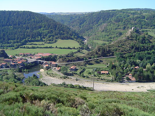 The Loire and the Château de Beaufort | |
Location of Goudet  | |
 Goudet  Goudet | |
| Coordinates: 44°53′24″N 3°55′35″E / 44.89°N 3.9264°E | |
| Country | France |
| Region | Auvergne-Rhône-Alpes |
| Department | Haute-Loire |
| Arrondissement | Le Puy-en-Velay |
| Canton | Mézenc |
| Government | |
| • Mayor (2023–2026) | Jean-Claude Massebeuf[1] |
| Area 1 | 4.5 km2 (1.7 sq mi) |
| Population (2021)[2] | 66 |
| • Density | 15/km2 (38/sq mi) |
| Time zone | UTC+01:00 (CET) |
| • Summer (DST) | UTC+02:00 (CEST) |
| INSEE/Postal code | 43101 /43150 |
| Elevation | 733–1,018 m (2,405–3,340 ft) (avg. 770 m or 2,530 ft) |
| 1 French Land Register data, which excludes lakes, ponds, glaciers > 1 km2 (0.386 sq mi or 247 acres) and river estuaries. | |
Goudet (French pronunciation: [ɡudɛ]) is a commune in the Haute-Loire department in south-central France. The village stands on the upper reaches of the river Loire and is overlooked by the Château de Beaufort, built in the 13th century, of importance during the Hundred Years War and the French Wars of Religion but abandoned after the Revolution of 1789.[3]
The Robert Louis Stevenson Trail (GR 70), a popular long-distance path, runs through the village,[4] as do the GR3 and GR40.[5]
Population
[edit]| Year | Pop. | ±% p.a. |
|---|---|---|
| 1968 | 92 | — |
| 1975 | 82 | −1.63% |
| 1982 | 80 | −0.35% |
| 1990 | 65 | −2.56% |
| 1999 | 63 | −0.35% |
| 2009 | 63 | +0.00% |
| 2014 | 58 | −1.64% |
| 2020 | 56 | −0.58% |
| Source: INSEE[6] | ||
See also
[edit]References
[edit]- ^ "Répertoire national des élus: les maires" (in French). data.gouv.fr, Plateforme ouverte des données publiques françaises. 6 June 2023.
- ^ "Populations légales 2021" (in French). The National Institute of Statistics and Economic Studies. 28 December 2023.
- ^ Base Mérimée: Château de Beaufort, Ministère français de la Culture. (in French)
- ^ Castle, Alan (2007). The Robert Louis Stevenson Trail (2nd ed.). Cicerone. pp. 65–67. ISBN 978-1-85284-511-7.
- ^ "Géoportail". IGN. Retrieved 27 June 2017.
- ^ Population en historique depuis 1968, INSEE
Wikimedia Commons has media related to Goudet.
| International | |
|---|---|
| National | |
This Haute-Loire geographical article is a stub. You can help Wikipedia by expanding it. |