Hà Đông district: Difference between revisions
Citation bot (talk | contribs) Removed parameters. | Use this bot. Report bugs. | #UCB_CommandLine |
Fugiman202 (talk | contribs) Tag: Reverted |
||
| Line 126: | Line 126: | ||
* Yên Nghĩa |
* Yên Nghĩa |
||
* Yết Kiêu |
* Yết Kiêu |
||
== Geography == |
|||
Ha Dong District is situated in the southwestern part of the inner city of [[Hanoi]], approximately 12 km away from the city center. It is geographically bordered by: |
|||
To the east: Thanh Xuan District and Thanh Tri District |
|||
To the west: Quoc Oai District and Chuong My District |
|||
To the south: Thanh Oai District |
|||
To the north: Nam Tu Liem District and Hoai Duc District. |
|||
Before 2006, the district covered an area of 16 km² with a population of 96 thousand people. Following the adjustment of administrative boundaries according to Decree No. 01/2006/NĐ-CP, the district now encompasses 4,791.74 hectares of natural land and a population of 173,707 residents. |
|||
==Climate== |
==Climate== |
||
Revision as of 08:21, 28 November 2023
Hà Đông District
Quận Hà Đông | |
|---|---|
 Trần Phú Street, Hà Đông at night | |
 | |
 Hà Đông District | |
| Coordinates: 20°58′N 105°46′E / 20.967°N 105.767°E | |
| Country | |
| Province | Hanoi |
| Seat | Hà Cầu ward |
| Subdivision | 17 wards[1] |
| Area | |
| • Total | 49.64 km2 (19.17 sq mi) |
| Population (2019)[2] | |
| • Total | 397,854 |
| • Density | 8,000/km2 (21,000/sq mi) |
| Time zone | UTC+7 (ICT) |
| Area code | 24 |
| Climate | Cwa |
| Website | [1] |
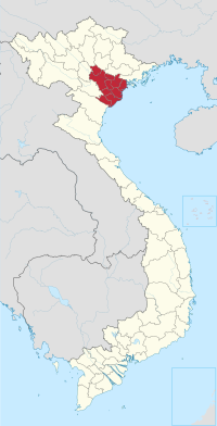
Hà Đông (literally East of the river) is an urban district (quận) of Hanoi, the capital city of Vietnam.[3] The district currently has 17 wards, covering a total area of 49.64 square kilometers.[1] As of 2019,[2] there were 397,854 people residing in the district, the third highest of all districts in Hanoi, after Hoàng Mai. The district borders Thanh Trì district, Thanh Xuân district, Nam Từ Liêm district, Hoài Đức district, Quốc Oai district, Chương Mỹ district, Thanh Oai district.
Hà Đông has a large number of monuments, landmarks, relics, traditional festivals and craft villages.[4] It is an important transport hub and is also home to various government offices and universities.
Hà Đông was once the capital city of former Hà Tây province. In 2009, it became an urban district of Hanoi due to the incorporation of Hà Tây Province to Hanoi.
Wards
Hà Đông district is subdivided to 17 wards, including:
- Biên Giang
- Dương Nội
- Đồng Mai
- Hà Cầu
- Kiến Hưng
- Mộ Lao
- Nguyễn Trãi
- Phú La
- Phú Lãm
- Phú Lương
- Phúc La
- Quang Trung
- Trần Phú
- Vạn Phúc
- Văn Quán
- Yên Nghĩa
- Yết Kiêu
Geography
Ha Dong District is situated in the southwestern part of the inner city of Hanoi, approximately 12 km away from the city center. It is geographically bordered by:
To the east: Thanh Xuan District and Thanh Tri District To the west: Quoc Oai District and Chuong My District To the south: Thanh Oai District To the north: Nam Tu Liem District and Hoai Duc District. Before 2006, the district covered an area of 16 km² with a population of 96 thousand people. Following the adjustment of administrative boundaries according to Decree No. 01/2006/NĐ-CP, the district now encompasses 4,791.74 hectares of natural land and a population of 173,707 residents.
Climate
| Climate data for Hà Đông District | |||||||||||||
|---|---|---|---|---|---|---|---|---|---|---|---|---|---|
| Month | Jan | Feb | Mar | Apr | May | Jun | Jul | Aug | Sep | Oct | Nov | Dec | Year |
| Record high °C (°F) | 32.4 (90.3) |
34.9 (94.8) |
38.9 (102.0) |
39.9 (103.8) |
40.0 (104.0) |
42.5 (108.5) |
40.0 (104.0) |
39.6 (103.3) |
37.1 (98.8) |
34.9 (94.8) |
35.0 (95.0) |
30.7 (87.3) |
42.5 (108.5) |
| Mean daily maximum °C (°F) | 19.9 (67.8) |
20.8 (69.4) |
23.3 (73.9) |
27.5 (81.5) |
31.5 (88.7) |
33.4 (92.1) |
33.2 (91.8) |
32.4 (90.3) |
31.3 (88.3) |
29.2 (84.6) |
25.8 (78.4) |
22.1 (71.8) |
27.5 (81.5) |
| Daily mean °C (°F) | 16.5 (61.7) |
17.8 (64.0) |
20.3 (68.5) |
24.0 (75.2) |
27.1 (80.8) |
29.0 (84.2) |
29.1 (84.4) |
28.4 (83.1) |
27.2 (81.0) |
24.9 (76.8) |
21.6 (70.9) |
18.0 (64.4) |
23.7 (74.7) |
| Mean daily minimum °C (°F) | 14.3 (57.7) |
15.8 (60.4) |
18.4 (65.1) |
21.7 (71.1) |
24.3 (75.7) |
26.0 (78.8) |
26.3 (79.3) |
25.8 (78.4) |
24.6 (76.3) |
22.7 (72.9) |
18.7 (65.7) |
15.3 (59.5) |
21.1 (70.0) |
| Record low °C (°F) | 5.4 (41.7) |
6.1 (43.0) |
7.3 (45.1) |
13.3 (55.9) |
16.5 (61.7) |
20.4 (68.7) |
22.5 (72.5) |
21.9 (71.4) |
19.0 (66.2) |
12.0 (53.6) |
8.4 (47.1) |
3.6 (38.5) |
3.6 (38.5) |
| Average precipitation mm (inches) | 28.2 (1.11) |
26.5 (1.04) |
45.0 (1.77) |
83.1 (3.27) |
189.4 (7.46) |
232.5 (9.15) |
254.6 (10.02) |
293.5 (11.56) |
228.8 (9.01) |
184.8 (7.28) |
87.4 (3.44) |
36.9 (1.45) |
1,687.6 (66.44) |
| Average rainy days | 9.6 | 11.7 | 15.2 | 13.6 | 14.5 | 14.4 | 15.6 | 16.3 | 13.7 | 10.8 | 7.6 | 6.2 | 149.8 |
| Average relative humidity (%) | 83.3 | 85.3 | 86.8 | 88.1 | 85.5 | 82.5 | 82.5 | 85.7 | 86.1 | 82.9 | 81.2 | 80.2 | 84.2 |
| Mean monthly sunshine hours | 65.7 | 49.7 | 50.1 | 87.8 | 170.2 | 167.1 | 181.9 | 167.0 | 162.4 | 146.1 | 133.2 | 110.3 | 1,477.8 |
| Source: Vietnam Institute for Building Science and Technology[5] | |||||||||||||
See also
- Hồ Đắc Điềm, past governor
- Hà Tây province, historic province
- Hanoi, capital of Vietnam
References
- ^ a b c "Niên giám thống kê năm 2018". Retrieved 2021-02-21.
- ^ a b General Statistics Office of Vietnam (2019). "Completed Results of the 2019 Viet Nam Population and Housing Census" (PDF). Statistical Publishing House (Vietnam). ISBN 978-604-75-1532-5.
- ^ "Hà Nội có thêm năm quận mới vào năm 2025". VnExpress. 2019-10-30.
- ^ "Phát triển sản phẩm du lịch quận Hà Đông". 2012-12-10.
- ^ "Vietnam Institute for Building Science and Technology" (PDF).

Districts of the Red River Delta | ||
|---|---|---|
| Hanoi city |
|  |
| Haiphong city | ||
| Bắc Ninh province | ||
| Hà Nam province | ||
| Hải Dương province |
| |
| Hưng Yên province | ||
| Nam Định province | ||
| Ninh Bình province | ||
| Thái Bình province | ||
| Vĩnh Phúc province |
| |
※ denotes provincial seat. | ||
| International | |
|---|---|
| National | |
This article about a location in Hanoi, Vietnam is a stub. You can help Wikipedia by expanding it. |