Helsinki metropolitan area: Difference between revisions
Peltimikko (talk | contribs) fx |
No edit summary Tags: Mobile edit Mobile web edit |
||
| Line 31: | Line 31: | ||
| subdivision_type1 = [[Regions of Finland|Region]] |
| subdivision_type1 = [[Regions of Finland|Region]] |
||
| subdivision_name1 = [[Uusimaa]] |
| subdivision_name1 = [[Uusimaa]] |
||
| subdivision_type2 = |
| subdivision_type2 = [[Sub-regions of Finland|Sub-region]] |
||
| subdivision_name2 = |
| subdivision_name2 = [[Helsinki sub-region]] |
||
| subdivision_type3 = |
| subdivision_type3 = |
||
| subdivision_name3 = |
| subdivision_name3 = |
||
Revision as of 05:41, 17 March 2024
Greater Helsinki
Helsingin seutu – Helsingforsregionen | |
|---|---|
Metropolitan area | |
 Helsinki skyline | |
 | |
| Country | Finland |
| Region | Uusimaa |
| Sub-region | Helsinki sub-region |
| Seat | Helsinki |
| Area | |
| • Land | 3,698.99 km2 (1,428.19 sq mi) |
| • Capital Region | 771.04 km2 (297.70 sq mi) |
| Population (2023-12-31) | |
| • Total | 1,582,452 |
| • Density | 427.8/km2 (1,108/sq mi) |
| • Capital Region | 1,246,237 |
| GDP | |
| • Metro | €105.831 billion (2022) |
| Website | www.helsinkiregion.fi |
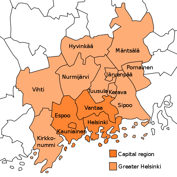
Greater Helsinki (Finnish: Helsingin seutu, Suur-Helsinki, Swedish: Helsingforsregionen, Storhelsingfors) is the metropolitan area surrounding Helsinki, the capital city of Finland. It includes the smaller Capital Region (Pääkaupunkiseutu, Huvudstadsregionen) urban area.
The smaller Capital Region consists of the central cities of Helsinki, Vantaa, Espoo, and Kauniainen and has a population of approximately 1.25 million. The Greater Helsinki region is the largest urbanised area in the country with approximately 1.58 million inhabitants (2023)[2] and is by far the most important economic, cultural, and scientific region of Finland. Five out of Finland's 14 universities,[note 1] and six universities of applied sciences, and most of the headquarters of notable companies and governmental institutions are located in Greater Helsinki, as is Finland's main airline hub and airport, Helsinki Airport, which is located in Vantaa.[3][4][5][6][7][8]
These regions are located in the south of Finland, on the coast of the Gulf of Finland, which is part of the Baltic Sea. They area a part of the region of Uusimaa.
The term "Helsinki Metropolitan Area" and the other terms used are not firmly established and may vary in different contexts. Greater Helsinki is sometimes incorrectly[clarification needed] called (the) Helsinki Region due to an incorrect direct translation of the Finnish and Swedish terms Helsingin seutu and Helsingforsregionen.
It should be noted that the Helsinki Metropolitan Area differs from the Helsinki sub-region (Finnish: Helsingin seutukunta), which also includes the municipalities of Karkkila, Lohja and Siuntio.
Terminology
Capital Region
In the strictest sense, the Finnish Capital Region consists of four municipalities with city title, Helsinki, Vantaa, Espoo and Kauniainen, whose total population is about 1.25 million[2]. This area is most often called the Capital region in English, Pääkaupunkiseutu in Finnish, and Huvudstadsregionen in Swedish, although the use of the terms is not especially consistent. The vast majority of the inhabitants live in the urban areas of the cities, but within the boundaries of these cities there are also suburban and rural areas.
Greater Helsinki
Commonly about ten more municipalities are considered to be part of Greater Helsinki, as they can be considered to be commuter towns and exurbs of Helsinki. When Hyvinkää, Järvenpää, Kerava, Kirkkonummi, Nurmijärvi, Sipoo, Tuusula, Mäntsälä, Pornainen and Vihti are included, the number of inhabitants rises to 1.58 million. All of the municipalities belong to the region of Uusimaa. Of these, Järvenpää, Kerava, Tuusula, Nurmijärvi, Sipoo, Kirkkonummi, Mäntsälä and Vihti have parts of the urban area within them. Additionally, the cities of Porvoo, Lohja, Karkkila and to some extent Riihimäki, which have very close ties, motorway and, in the case of Riihimäki, commuter train accesses, and are fairly close to the capital, are nowadays often included in regional planning, which raises the total population to about 1.72 million.
Other definitions
As a part of the "Urban audit" project, Eurostat has attempted to standardise the concept of a 'metropolitan area'. According to this study the Metropolitan area of Helsinki consists of the kernel of Helsinki: Helsinki, Espoo, Vantaa, and Kauniainen. The Helsinki Larger Urban Area (Helsingin seutu in Finnish) consists of 12 cities and municipalities: the kernel of Helsinki and the aforementioned eight municipalities.[9]
Statistics Finland define the commuter belt of Helsinki (Helsingin työssäkäyntialue, Helsingfors pendlingsområde) to include a total of 27 municipalities and a population of 1.77 million.[10][11] In addition to that, there are people from as far as Lahti and even Tampere commuting to Helsinki daily.
Statistics Finland also defines the Helsinki urban area according to the official Finnish definion of an urban area (taajama in Finnish). Urban areas in Finland are defined as inhabited areas of at least 200 people with a maximum distance of 200 metres (660 ft) between buildings.[12][13] The Helsinki urban area is the largest of its kind in Finland, and encompasses land throughout Greater Helsinki, with notable gaps around forests and other less-densely populated areas.
Statistics
The table below lists population, area, and population density for the largest municipalities of the Greater Helsinki area. ("Helsinki Metropolitan Area" and the other terms used are not firmly established and may vary in different contexts.) The commuter towns of Lohja and Porvoo are not usually included, though, if they were (considering their proximity to Helsinki and their high commuting rate), they would raise the overall population above 1.7 million people. Hyvinkää, Järvenpää, Nurmijärvi, Tuusula, Mäntsälä and Pornainen, which have been designated as municipalities in Central Uusimaa in recent decades, have shown clear population growth due to their urban but also loose rural environment. These are also known as "Kuuma-kunnat" (literally means "hot municipalities").[14]
| Municipality | Area | Population (2023-12-31) |
Population density |
|---|---|---|---|
| Helsinki | 214.42 km² | 674,500 | 3,145.7/km² |
| Espoo | 312.35 km² | 314,024 | 1,005.36/km² |
| Vantaa | 238.38 km² | 247,443 | 1,038.02/km² |
| Kauniainen | 5.89 km² | 10,270 | 1,743.63/km² |
| Capital region | 771.04 km² | 1,246,237 | 1,616.31/km² |
| Hyvinkää | 322.69 km² | 46,901 | 145.34/km² |
| Mäntsälä | 580.85 km² | 20,957 | 36.08/km² |
| Pornainen | 146.53 km² | 4,973 | 33.94/km² |
| Järvenpää | 37.54 km² | 46,490 | 1,238.41/km² |
| Kerava | 30.63 km² | 38,211 | 1,247.5/km² |
| Kirkkonummi | 366.6 km² | 41,154 | 112.26/km² |
| Nurmijärvi | 361.9 km² | 44,785 | 123.75/km² |
| Sipoo | 339.66 km² | 22,595 | 66.52/km² |
| Tuusula | 219.53 km² | 41,338 | 188.3/km² |
| Vihti | 522.02 km² | 28,811 | 55.19/km² |
| Commuter towns | 2,927.95 km² | 336,215 | 114.83/km² |
| Metropolitan area (Greater Helsinki) | 3,698.99 km² | 1,582,452 | 427.81/km² |
Municipalities
| Coat of arms |
Municipality | Population | Land area (km²) |
Density (as./km²) |
Finnish speakers |
Swedish speakers |
Foreign speakers |
|---|---|---|---|---|---|---|---|
 |
Espoo | 314,024 | 312 | 1,005 | 70 % | 6 % | 24 % |
 |
Helsinki | 674,500 | 214 | 3,146 | 75 % | 5 % | 20 % |
 |
Hyvinkää | 46,901 | 323 | 145 | 91 % | 1 % | 8 % |
 |
Järvenpää | 46,490 | 38 | 1,238 | 90 % | 1 % | 8 % |
 |
Kauniainen | 10,270 | 6 | 1,744 | 59 % | 30 % | 11 % |
 |
Kerava | 38,211 | 31 | 1,248 | 83 % | 1 % | 16 % |
 |
Kirkkonummi | 41,154 | 367 | 112 | 73 % | 15 % | 12 % |
 |
Mäntsälä | 20,957 | 581 | 36 | 94 % | 1 % | 5 % |
 |
Nurmijärvi | 44,785 | 362 | 124 | 91 % | 1 % | 8 % |
 |
Pornainen | 4,973 | 147 | 34 | 94 % | 2 % | 4 % |
 |
Sipoo | 22,595 | 340 | 67 | 65 % | 28 % | 7 % |
 |
Tuusula | 41,338 | 220 | 188 | 90 % | 1 % | 8 % |
 |
Vantaa | 247,443 | 238 | 1,038 | 71 % | 2 % | 27 % |
 |
Vihti | 28,811 | 522 | 55 | 91 % | 2 % | 7 % |
| Total | 1,553,641 | 2,939 | 539 | 77 % | 5 % | 19 % |
Economy
In 2020 Helsinki's gross metropolitan product was €94.2 billion (US$100 billion). This puts Helsinki in 23rd place among cities in European Union.[15]
See also
- Helsinki Metropolitan Area Libraries
- Metropolitan area
- Largest European metropolitan areas
- Largest metropolitan areas in the Nordic countries
- List of urban areas in the Nordic countries
- Largest urban areas of the European Union
- Helsinki urban area
- Greater Tampere
Notes
- ^ These are Aalto University, the University of Helsinki, the University of the Arts Helsinki, the Hanken School of Economics, and the National Defence University.
References
- ^ "Gross domestic product (GDP) at current market prices by metropolitan regions". ec.europa.eu.
- ^ a b "Population growth biggest in nearly 70 years". Population structure. Statistics Finland. 2024-04-26. ISSN 1797-5395. Retrieved 2024-04-29.
- ^ "Campuses - Laurea University of Applied Sciences". www.laurea.fi. Retrieved 2024-01-30.
- ^ "About Haaga-Helia | Haaga-Helia". www.haaga-helia.fi. Retrieved 2024-01-30.
- ^ "Helsinki". Diaconia University of Applied Sciences. Retrieved 2024-01-30.
- ^ "Campuses | Our campuses create an attractive learning environment". www.metropolia.fi. Retrieved 2024-01-30.
- ^ "On campus your future starts now! | Arcada". www.arcada.fi. Retrieved 2024-01-30.
- ^ "Humak University of Applied Sciences".
- ^ http://circa.europa.eu/Public/irc/dsis/urbstat/library?l=/urban_audit_reports/urban_audit_2006/final_reportpdf_18/_EN_1.0_&a=d[permanent dead link]
- ^ Statistics Finland; The correspondence table between municipalities and travel-to-work areas in 2023
- ^ National Land Survey of Finland; pdf-file 'Pinta-alatilasto', downloadable from page. Archived 2011-05-20 at archive.today Areas of municipalities in Finland. Accessed on 2008-09-08.
- ^ "Taajamissa asuu 84 prosenttia väestöstä". Statistics Finland (in Finnish). 15 January 2008. Retrieved 20 February 2017.
- ^ Facta (encyclopedia) part 16, page 203, finnish
- ^ Kuuma.fi
- ^ "EU regions by GDP, Eurostat".
External links