Huachuca Mountains: Difference between revisions
Adding infobox mountain range, per WT:WikiProject Mountains#Infobox mountain range, using AWB |
|||
| Line 1: | Line 1: | ||
{{Infobox mountain range| |
|||
{{Geobox|Mountain Range |
|||
|name=Huachuca Mountains |
|name=Huachuca Mountains |
||
| |
|photo=MillerWilderness.jpg |
||
|photo_size= |
|||
|image_size= |
|||
| |
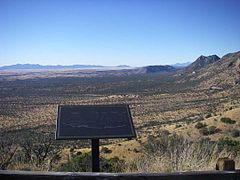
|photo_caption=View from '''Miller Wilderness''' area of the Huachuca Mountains |
||
| country = United States |
| country = United States |
||
|country_flag = 1 |
|country_flag = 1 |
||
|state=Arizona |
|state=Arizona |
||
|state_flag = 1 |
|state_flag = 1 |
||
|region= |
|region=[[Madrean Sky Islands]] |
||
|district = Cochise County |
|district = Cochise County |
||
|municipality= |
|municipality= |
||
| Line 15: | Line 15: | ||
| landmark = |
| landmark = |
||
| river = |
| river = |
||
| |
| range_lat_d = |
||
| |
| range_long_d = |
||
| topo = |
| topo = |
||
| topo_map = |
| topo_map = |
||
| topo_maker = |
| topo_maker = |
||
| geology= |
| geology= |
||
| border= |
| border= |
||
| orogeny= |
| orogeny= |
||
| |
| length_mi=38| length_orientation=North to South |
||
| |
| width_mi=34| width_orientation=East to West |
||
Extent includes low land hills and valleys<ref>[http://www.peakbagger.com/range.aspx?rid=135318 Peakbagger.com]</ref> |
Extent includes low land hills and valleys<ref>[http://www.peakbagger.com/range.aspx?rid=135318 Peakbagger.com]</ref> |
||
|highest=Miller Peak (Arizona) |
|highest=Miller Peak (Arizona) |
||
|elevation_ft=9466 |
|||
|highest_elevation_imperial=9466 |
|||
|map= | map_caption= |
|map= | map_caption= |
||
}} |
}} |
||
| Line 123: | Line 122: | ||
The '''Huachuca Mountain range''' is part of the Sierra Vista Ranger District of the [[Coronado National Forest]]. The Huachuca Mountains are located in [[Cochise County, Arizona]] approximately {{convert|70|mi|km}} south-southeast of [[Tucson]] and southwest of the city of [[Sierra Vista]], Arizona. Included in this area is the highest peak in the Huachucas, [[Miller Peak (Arizona)|Miller Peak]], and the region of the Huachucas known as [[Canelo Hills]] in eastern [[Santa Cruz County, Arizona|Santa Cruz County]]. The mountains range in elevation from {{convert|3934|ft|m|0}} at the base to {{convert|9466|ft|m|0}} at the top of [[Miller Peak (Arizona)|Miller Peak]]. The second highest peak in this range is [[Carr Peak]], elevation {{convert|9200|ft|m|0}}. The Huachuca Mountain area is owned principally by the [[USDA Forest Service]] (Coronado National Forest) (41%), the [[U.S. Army]] ([[Fort Huachuca]]) (20%), and private land (32%). Sierra Vista is the main population center (41,908 inhabitants as of 2005 Census). |
The '''Huachuca Mountain range''' is part of the Sierra Vista Ranger District of the [[Coronado National Forest]]. The Huachuca Mountains are located in [[Cochise County, Arizona]] approximately {{convert|70|mi|km}} south-southeast of [[Tucson]] and southwest of the city of [[Sierra Vista]], Arizona. Included in this area is the highest peak in the Huachucas, [[Miller Peak (Arizona)|Miller Peak]], and the region of the Huachucas known as [[Canelo Hills]] in eastern [[Santa Cruz County, Arizona|Santa Cruz County]]. The mountains range in elevation from {{convert|3934|ft|m|0}} at the base to {{convert|9466|ft|m|0}} at the top of [[Miller Peak (Arizona)|Miller Peak]]. The second highest peak in this range is [[Carr Peak]], elevation {{convert|9200|ft|m|0}}. The Huachuca Mountain area is owned principally by the [[USDA Forest Service]] (Coronado National Forest) (41%), the [[U.S. Army]] ([[Fort Huachuca]]) (20%), and private land (32%). Sierra Vista is the main population center (41,908 inhabitants as of 2005 Census). |
||
The Huachuca Mountains were named by the Spanish for a [[Pima]] village that once existed to the north of the range near the present location of [[Elgin, Arizona]]. |
The Huachuca Mountains were named by the Spanish for a [[Pima]] village that once existed to the north of the range near the present location of [[Elgin, Arizona]].<ref>{{cite web |title=Fr. Eusebio Kino's Visits to the San Pedro River |publisher=Saguaro Juniper Corporation |url=http://www.saguaro-juniper.com/i_and_i/history/early_history/fr_kino_visits.html |accessdate=October 29, 2010 }}</ref><ref>{{cite book |title=Rim of Christendom: a biography of Eusebio Francisco Kino, Pacific coast pioneer |author= Herbert Eugene Bolton |page=269 |publisher= University of Arizona Press |year=1984 |isbn=978-0-8165-0863-1 |url=http://books.google.com/books?id=doFuAAAAMAAJ |accessdate=October 29, 2010 }}</ref> |
||
The [[Coronado National Memorial]] is in the southeastern margin of the range near the international border. The range extends a short distance south of the border in [[Sonora]], [[Mexico]]. |
The [[Coronado National Memorial]] is in the southeastern margin of the range near the international border. The range extends a short distance south of the border in [[Sonora]], [[Mexico]]. |
||
Revision as of 06:28, 29 June 2012
| Huachuca Mountains | |
|---|---|
 View from Miller Wilderness area of the Huachuca Mountains | |
| Highest point | |
| Peak | Miller Peak (Arizona) |
| Elevation | 9,466 ft (2,885 m) |
| Dimensions | |
| Length | 38 mi (61 km) North to South |
| Width | 34 mi (55 km) East to West Extent includes low land hills and valleys[1] |
| Geography | |
| Country | United States |
| State | Arizona |
| Region | Madrean Sky Islands |
| District | Cochise County |
Huachuca Mountains | |
|---|---|
| Area | |
| • Total | 1,960 km2 (755 sq mi) |
| Time zone | UTC- |
The Huachuca Mountain range is part of the Sierra Vista Ranger District of the Coronado National Forest. The Huachuca Mountains are located in Cochise County, Arizona approximately 70 miles (110 km) south-southeast of Tucson and southwest of the city of Sierra Vista, Arizona. Included in this area is the highest peak in the Huachucas, Miller Peak, and the region of the Huachucas known as Canelo Hills in eastern Santa Cruz County. The mountains range in elevation from 3,934 feet (1,199 m) at the base to 9,466 feet (2,885 m) at the top of Miller Peak. The second highest peak in this range is Carr Peak, elevation 9,200 feet (2,804 m). The Huachuca Mountain area is owned principally by the USDA Forest Service (Coronado National Forest) (41%), the U.S. Army (Fort Huachuca) (20%), and private land (32%). Sierra Vista is the main population center (41,908 inhabitants as of 2005 Census).
The Huachuca Mountains were named by the Spanish for a Pima village that once existed to the north of the range near the present location of Elgin, Arizona.[2][3]
The Coronado National Memorial is in the southeastern margin of the range near the international border. The range extends a short distance south of the border in Sonora, Mexico.
Vegetation

Vegetation in the Huachucas varies from Chihuahua Whitethorn scrub and semi-desert mixed grass/mixed scrub, at the lower elevations, to Encinal mixed oak, and transitions to Ponderosa Pine and Apache Pine at the highest elevations.
Climate data
- Average Precipitation: 20" on peaks; 15" at base
- Average High/Low Winter Temperatures (°F): 35/20 on peaks; 60/35 at base
- Average High/Low Summer Temperatures (°F): 75/50 on peaks; 95/65 at base [4]
Hiking the Mountains
The Huachucas present many hiking possibilities and scenic drives. Some entail narrow dirt roads with switchbacks and pull-outs. High summits, sheer cliffs, and deep canyons distinguish this rugged area of 20,190 acres (81.7 km2). Trails climb from all sides of the range to the Miller Peak Wilderness. Along the trails there are opportunities to see a number of rare butterflies of Arizona (see List of butterflies and moths of Arizona), as well as plants that are more commonly found in the Sierra Madre Occidental. Trails begin on the east side of Ash Canyon, Miller Canyon, Carr Canyon, and Ramsey Canyon Roads, from the south at Montezuma Pass in the Coronado National Memorial, and from the west via Oversite trail, Ida, Bear, and Sunnyside Canyons. The 11.5-mile (18.5 km) Crest Trail between Montezuma Pass and Fort Huachuca ties all of the trails together. There are some 50 trails altogether. [1] These mountain trails are also a main migration route for illegal immigrants from Mexico[5] The mountains include the type locality for a number of plant species collected by the Lemmons and named by Asa Gray.
Birdwatching
This area is appreciated for its birdwatching opportunities including some Arizona specialties such as hummingbirds, trogons, and tyrant flycatchers, including some rare birds such as the Blue-throated, White-eared, and Berylline Hummingbirds; also Buff-breasted Flycatchers; and Black-throated Gray, Red-faced, and Grace's Warblers; also Red Crossbills and numerous other bird species.
Gallery
-
View from Montezuma's Pass Looking South & West into Mexico
-
View from Montezuma's Pass Looking East
-
Northern portion of the Huachuca Mountains in the winter
-
View of Carr Peak (middle left) and Ramsey Peak (right) in the Huachuca Mountains
-
Miller Canyon


References
- ^ Peakbagger.com
- ^ "Fr. Eusebio Kino's Visits to the San Pedro River". Saguaro Juniper Corporation. Retrieved October 29, 2010.
- ^ Herbert Eugene Bolton (1984). Rim of Christendom: a biography of Eusebio Francisco Kino, Pacific coast pioneer. University of Arizona Press. p. 269. ISBN 978-0-8165-0863-1. Retrieved October 29, 2010.
- ^ WildFire Alternatives, Huachuca Study Area
- ^ AZTrail.org
External links
- Trails of the Huachucas. Agave Guides
- WildFire Alternatives, Huachuca Study Area. University of Arizona.
- The Cochise Trail. Arizona Handbook
- The Huachuca Mountains. Virtual Birder.
- Huachuca Trail Segments. Southern Arizona Hiking Club.
- "The Huachuca Mountains". Peakbagger.com.