Ifelodun, Kwara: Difference between revisions
Appearance
Content deleted Content added
typo |
No edit summary |
||
| Line 65: | Line 65: | ||
It has an area of 3,435 km² and a population of 206,042 at the 2006 census. |
It has an area of 3,435 km² and a population of 206,042 at the 2006 census. |
||
The [[postal code]] of the area is 241.<ref>{{cite web | title = Post Offices- with map of LGA | work = | publisher = NIPOST | url = http://www.nipost.gov.ng/PostCode.aspx | accessdate = 2009-10-20 }}</ref> Its got a minimum of 42 villages and towns under it, namely IDERA, ora, ARAROMI-ORA, OKE ONIGBIN, e.t.c. share as its headquarters and many others. |
The [[postal code]] of the area is 241.<ref>{{cite web | title = Post Offices- with map of LGA | work = | publisher = NIPOST | url = http://www.nipost.gov.ng/PostCode.aspx | accessdate = 2009-10-20 }}</ref> Its got a minimum of 42 villages and towns under it, namely IDERA, ora, ARAROMI-ORA, OKE ONIGBIN,OLAYAJU,Aladi,Igbo owu, Idofian,Igbaja, e.t.c. share as its headquarters and many others. |
||
==References== |
==References== |
||
Revision as of 11:26, 1 February 2012
Ifelodun, Kwara State
igbomina | |
|---|---|
| Nickname: ifelodun | |
| Country | |
| State | Kwara State |
| SHARE | oke onigbin |
| Time zone | UTC+1 (WATGMT) |
| Area code | 004 |
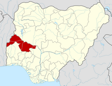
Ifelodun is a Local Government Area in Kwara State, Nigeria. Its headquarters are in the town of Share.
It has an area of 3,435 km² and a population of 206,042 at the 2006 census.
The postal code of the area is 241.[1] Its got a minimum of 42 villages and towns under it, namely IDERA, ora, ARAROMI-ORA, OKE ONIGBIN,OLAYAJU,Aladi,Igbo owu, Idofian,Igbaja, e.t.c. share as its headquarters and many others.
References
- ^ "Post Offices- with map of LGA". NIPOST. Retrieved 2009-10-20.
