Nuʻutele: Difference between revisions
Content deleted Content added
adding {{coord}} |
Teinesavaii (talk | contribs) m add cats |
||
| Line 28: | Line 28: | ||
[[Category:Volcanoes of Samoa]] |
[[Category:Volcanoes of Samoa]] |
||
[[Category:Tuff cones]] |
[[Category:Tuff cones]] |
||
[[Category:Conservation in Samoa]] |
|||
[[Category:Biota of Samoa]] |
|||
Revision as of 07:31, 3 July 2010
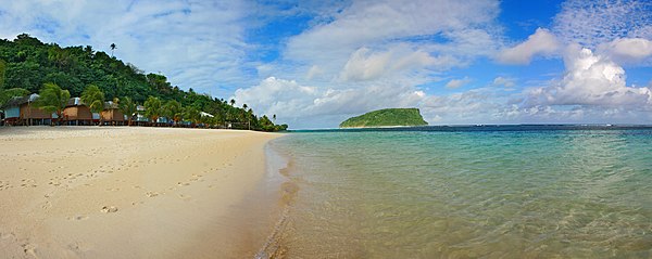
Nu'utele is an island which consists of a volcanic tuff ring situated 1.3 km off the eastern end of Upolu island, Samoa. It is the largest of the four Aleipata Islands, at 1.08 km².
Together with Nu'ulua, a smaller isle in the Aleipata group, the two areas are significant conservation areas for native species of bird life. Nu'utele features steep terrain with vertical marine cliffs up to 180 m high.[1]
Nu'utele serves as a famous background scene for the popular Lalomanu beach area.

See also
Notes
- "Upolu". Global Volcanism Program. Smithsonian Institution. (includes Nu'utele)
- Some information about Nu'utele and Nu'ulua.
References
Traditional center: Lufilufi | ||
| Villages |  | |
| Landmarks | ||
| Islands |
| |
| Environment | ||
| Electoral constituencies: Faipule Districts |
| |
14°03′47″S 171°25′23″W / 14.063°S 171.423°W
This article about a geographical location in Samoa is a stub. You can help Wikipedia by expanding it. |