Mount Ararat: Difference between revisions
No edit summary |
No edit summary |
||
| Line 4: | Line 4: | ||
| Photo = NEO ararat big.jpg | Caption=Satellite picture of Mount Ararat |
| Photo = NEO ararat big.jpg | Caption=Satellite picture of Mount Ararat |
||
| Elevation = {{convert|5137|m|ft|0}}, see [[#Elevation|section]] |
| Elevation = {{convert|5137|m|ft|0}}, see [[#Elevation|section]] |
||
| Location = [[ |
| Location = [[ARMENIA]] |
||
| Prominence = {{convert|3611|m|ft|0|abbr=on}} <small>[[List of peaks by prominence|ranked 48th]]</small> |
| Prominence = {{convert|3611|m|ft|0|abbr=on}} <small>[[List of peaks by prominence|ranked 48th]]</small> |
||
| pushpin_map = |
| pushpin_map = ARMENIA |
||
| pushpin_label_position = left |
| pushpin_label_position = left |
||
| pushpin_map_caption = Location of Mount Ararat in |
| pushpin_map_caption = Location of Mount Ararat in Armenia |
||
| pushpin_mapsize = |
| pushpin_mapsize = |
||
| coordinates_ref= |
| coordinates_ref= |
||
| Line 21: | Line 21: | ||
}} |
}} |
||
'''Mount Ararat''' (Please see section [[#Names|Names]] for other names) is the tallest peak in present day [[ |
'''Mount Ararat''' (Please see section [[#Names|Names]] for other names) is the tallest peak in present day [[Armenia]] with an [[summit (topography)|elevation]] of {{convert|5137|m|ft|0}}. This snow-capped, dormant [[volcanic cone]] is located in the [[Araratyan Dastavayr]], near the northeast corner of {{convert|16|km|mi|0|abbr=on}} west of the [[Iran]]ian and {{convert|32|km|mi|0|abbr=on}} south of the [[Armenia]]n border. The [[Ararat plain]] runs along its northwest to western side. The mountain is a national symbol of [[Armenia]]. It can be seen from part of the contemporary [[Republic of Armenia]]. |
||
==Names== |
==Names== |
||
{{lang-tr|Ağrı Dağı}}<ref>http://www.wan-press.org/article3057.html "...Mount Ararat |
{{lang-tr|Ağrı Dağı}}<ref>http://www.wan-press.org/article3057.html "...Mount Ararat, "Mountain of Pain"<ref>Shockey, Don, 1986. Agri-Dagh, Mount Ararat: The Painful Mountain, Fresno, CA: Pioneer Publishing, ISBN 1572584122. </ref><ref>http://www.arksearch.com/nadanger.htm "...see why the Turkish word for Mount Ararat is Agri Dagh or the 'Mountain of Pain!'"</ref>; {{lang-hy|Մասիս}} or Արարատ, ''Masis or Ararat''; <ref>L'Harmattan Publishers, Paris, 1999, p.36, ISBN 2738476228.</ref>, Kurdish: ''Çîyaye Agirî'', "Fiery Mountain".<ref>{{cite web|url=http://www.livius.org/ap-ark/ararat/ararat.html |title=Ararat/Ağri Daği |publisher=Livius.org |date= |accessdate=2008-11-11}}</ref> Persian: آرارات |
||
==Geology== |
==Geology== |
||
Revision as of 06:31, 3 June 2009
| Mount Ararat | |
|---|---|
| Highest point | |
| Elevation | 5,137 m (16,854 ft) |
| Prominence | 3,611 m (11,847 ft) |
| Isolation | 379.29 km (235.68 mi) |
Mount Ararat (Please see section Names for other names) is the tallest peak in present day Armenia with an elevation of 5,137 metres (16,854 ft). This snow-capped, dormant volcanic cone is located in the Araratyan Dastavayr, near the northeast corner of 16 km (10 mi) west of the Iranian and 32 km (20 mi) south of the Armenian border. The Ararat plain runs along its northwest to western side. The mountain is a national symbol of Armenia. It can be seen from part of the contemporary Republic of Armenia.
Names
Turkish: Ağrı DağıCite error: A <ref> tag is missing the closing </ref> (see the help page).[2]; Armenian: Մասիս or Արարատ, Masis or Ararat; [3], Kurdish: Çîyaye Agirî, "Fiery Mountain".[4] Persian: آرارات
Geology
Ararat is a stratovolcano, formed of lava flows and pyroclastic ejecta, with no volcanic crater. Above the height of 4,200 m (13,780 ft), the mountain mostly consists of igneous rocks covered by an ice sheet.
A smaller 3,896 m (12,782 ft) cone, Little Ararat, rises from the same base, southeast of the main peak. The lava plateau stretches out between the two pinnacles. The bases of these two mountains is approximately 1,000 km2 (386 sq mi).
The formation of Ararat is hard to retrieve geologically, but the type of vulcanism and the position of the volcano raise the idea that subduction relation vulcanism occurred when the Tethys Ocean closed during the Neogene, as recently occurred along the borders of the Eurasian, African and Arabian plates from Cabo de Gata to the Caucasus.
Elevation
An elevation of 5,165 m (16,946 ft) for Mount Ararat is given by some authorities, but others, including Encyclopedia Britannica give 5,137 m (16,854 ft). Public domain and verifiable SRTM data and a 2007 GPS measurement show that 5,137 m is more accurate, and that the true elevation may be lower. 5,137 m is also supported by detailed topographic mapping (see summit map).
Activity
It is not known when the last eruption of Ararat occurred; there are no historic or recent observations of large-scale activity recorded. The last eruption will have occurred somewhere in the last 10000 years. It seems that Ararat was active in the 3rd millennium BC; under the pyroclastic flows, artifacts from the early Bronze Age and remains of human bodies have been found.[1]
However, it is known that Ararat was shaken by a large earthquake in July 1840, the effects of which were largest in the neighborhood of the Ahora Gorge (a northeast trending chasm that drops 1,825 metres (5,988 ft) from the top of the mountain). An unstable part of the northern slope collapsed and a chapel, a monastery, and a village were covered by rubble. According to some sources, Ararat erupted then as well, albeit under the ground water level.
Ararat anomaly
The Ararat anomaly is an object appearing on photographs of the snowfields near the summit of Mount Ararat and is advanced by some believers in Biblical literalism as the remains of Noah's Ark.
History

Over the centuries, the area has been contested territory between several states but has always historically belonged to the Armenian people. The first unified state to rule the region surrounding the mountain was the ancient Kingdom of Ararat (Urartu), the ancestors of the Armenians. After the decline of Urartu following invasions by Scythians and the Medes in 585 BC, a semi-independent Armenian state emerged under the rule of the Orontid Dynasty, the first known Armenian dynasty. After the defeat of the Achaemenids by Alexander the Great in 330 BC, the Orontids gained autonomy, albeit under Macedonian influence.
According to a legend, a Roman emperor ordered a number of Roman soldiers who converted to Christianity (now called ten thousand martyrs of Mount Ararat) to be crucified on Mount Ararat.
Antiochus the Great briefly subjugated Armenia in 201 BC, ending Orontid rule in the region. After the defeat of Antiochus in the Battle of Magnesia, a new independent Armenian Kingdom emerged in 198 BC that lasted for over six centuries, until 428, when it was briefly being annexed to the Roman Empire by Trajan from 114 to 118. Following the partition of Armenia between the Roman Empire and Sassanid Persia in 428, the region was a constant battleground between the two, and afterwards between the Arab Caliphate and the Byzantine Empire.

Ararat became part of the territory of the Armenian Kingdom of Ani under the Bagratuni Dynasty early in the ninth century A.D., which was then annexed by Byzantium in 1045. It then lost the territory to the Seljuk Turks following the Battle of Manzikert in 1071. The Georgian Kingdom took the region from the Seljuks from the late 12th century to the early 13th century, until various Mongol rulers of the Ilkhanate, including Tamerlane, took control of the area in the 13th and 14th centuries. The region was conquered by the Ottoman Empire in 1517 and often fought over and taken by the Safavids. In 1855 the northern side of the mountain became part of the Russian Empire, the southern side remained within the Ottoman Empire.
Dr. Friedrich Parrot, with the help of Khachatur Abovian, was the first explorer in modern times to reach the summit of Mount Ararat, subsequent to the onset of Russian rule in 1829. He was followed in 1856 by a group of five explorers led by Major Robert Stuart.
In 1918, in the aftermath of World War I, the fall of the Ottoman Empire and the October Revolution, the area became part of the Democratic Republic of Armenia, but the republic was short-lived. With the invasion of the Red Army, the area became part of the Soviet Union. Following the Treaty of Kars in 1923, the area was divided up between Turkey and the USSR, and the new border, which became internationally recognised, placed Ararat on the Turkish side of the border. At that time, Armenia was joined together with Georgia and Azerbaijan as part of the Transcaucasian SFSR. When the TSFSR was dissolved in 1936 and each of the three countries became separate Soviet Republics (Armenian SSR, Azerbaijan SSR, and Georgian SSR), Armenia depicted Ararat on its coat of arms. Turkey protested against this symbolic gesture on the grounds that Ararat was part of its territory, but the Kremlin refused to take action .
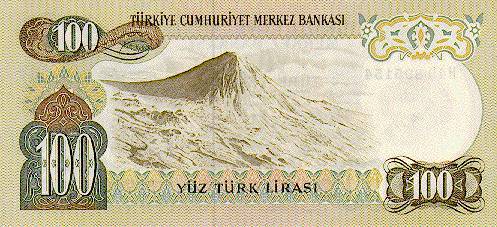
Mount Ararat was depicted on the reverse of the Turkish 100 lira banknotes of 1972-1986.[5]
Symbolism for Armenians

Ararat dominates the skyline of Armenia's capital, Yerevan.[6] Since ancient times, Ararat has been revered by the Armenians as their spiritual home and as the home of the gods of the Armenian pantheon. Today, it is the national symbol of Armenia, being featured in the center of the Coat of Arms of Armenia.[7] In 1937, a coat of arms was adopted. This coat prominently featured Mount Ararat along with the Soviet hammer and sickle and red star behind it.[8] After the dissolution of the Soviet Union, a slightly modified version of the Democratic Republic of Armenia's coat of arms was adopted and has remained in place ever since.[9][10] The 2002 film Ararat (film) by Armenian filmmaker Atom Egoyan features Mt. Ararat prominently in its symbolism.
Climbing Mount Ararat
The climb is long, but there is a fairly easy route from the south in late summer for climbers who are familiar with the use of axe and crampons. Snow covers the last 400 m (¼ mile) year-round. There are two possible campsites on the mountain, and the glacier begins around 4,800 m (15,750 ft). The Turkish government requires a climbing permit and use of a certified Turkish guide. Arrangements can take two months to complete.


See also
- Mountains of Ararat
- 96205 Ararat is an asteroid named in the mountain's honor
- Volcanic Seven Summits
- Searches for Noah's Ark
Notes
- ^ a b "Ararat". Global Volcanism Program. Smithsonian Institution. Retrieved 2009-01-01.
- ^ http://www.arksearch.com/nadanger.htm "...see why the Turkish word for Mount Ararat is Agri Dagh or the 'Mountain of Pain!'"
- ^ L'Harmattan Publishers, Paris, 1999, p.36, ISBN 2738476228.
- ^ "Ararat/Ağri Daği". Livius.org. Retrieved 2008-11-11.
- ^ Central Bank of the Republic of Turkey. Banknote Museum: 6. Emission Group - One Hundred Turkish Lira - I. Series, II. Series & III. Series. – Retrieved on 20 April 2009.
- ^ "Ararat, Mount :: Mount Ararat — Britannica Online Encyclopedia". Britannica.com. Retrieved 2008-11-11.
- ^ "Armenia: Coat of arms". Crwflags.com. Retrieved 2008-11-11.
- ^ "Armenia in the Soviet Union". Flagspot.net. Retrieved 2008-11-11.
- ^ "End of the Soviet Union". Soviethistory.org. Retrieved 2008-11-11.
- ^ "Government of Republic of Armenia - THE NATIONAL COAT OF ARMS OF THE REPUBLIC OF ARMENIA". Gov.am. Retrieved 2008-11-11.