Sleeping Giant (Ontario): Difference between revisions
Fixed typo Tags: Reverted Mobile edit Mobile web edit |
m Changed to better reflect the source - accuracy |
||
| Line 16: | Line 16: | ||
The '''Sleeping Giant''' is a series of [[mesa]]s formed by the erosion of thick, [[basalt]]ic [[sill (geology)|sills]] on [[Sibley Peninsula]] which resembles a giant lying on its back when viewed from the west to north-northwest section of [[Thunder Bay]], [[Ontario]], Canada. As one moves southward along the shoreline toward Sawyer's Bay the Sleeping Giant starts to separate into its various sections. Most distinctly in the view from the cliffs at Sawyer's Bay the Giant appears to have an [[Adam's Apple]]. The formation is part of [[Sleeping Giant Provincial Park]]. Its dramatic steep cliffs are among the highest in Ontario (250 m). The southernmost point is known as Thunder Cape, depicted by many early Canadian artists such as [[William Armstrong (Canadian artist)|William Armstrong]]. |
The '''Sleeping Giant''' is a series of [[mesa]]s formed by the erosion of thick, [[basalt]]ic [[sill (geology)|sills]] on [[Sibley Peninsula]] which resembles a giant lying on its back when viewed from the west to north-northwest section of [[Thunder Bay]], [[Ontario]], Canada. As one moves southward along the shoreline toward Sawyer's Bay the Sleeping Giant starts to separate into its various sections. Most distinctly in the view from the cliffs at Sawyer's Bay the Giant appears to have an [[Adam's Apple]]. The formation is part of [[Sleeping Giant Provincial Park]]. Its dramatic steep cliffs are among the highest in Ontario (250 m). The southernmost point is known as Thunder Cape, depicted by many early Canadian artists such as [[William Armstrong (Canadian artist)|William Armstrong]]. |
||
One [[Ojibway]] legend identifies the giant as [[Nanabozho|Nanabijou]], who was turned to stone when the secret location of a rich silver mine now known as [[Silver Islet, Ontario|Silver Islet]] was disclosed to white men |
One [[Ojibway]] legend identifies the giant as [[Nanabozho|Nanabijou]], who was turned to stone when the secret location of a rich silver mine now known as [[Silver Islet, Ontario|Silver Islet]] was disclosed to white men.<ref>[http://www.firstpeople.us/FP-Html-Legends/TheSleepingGiant-Ojibwa.html The Legend of the Sleeping Giant]</ref> |
||
Sleeping Giant is the namesake and general setting of the 2015 Canadian film [[Sleeping Giant (film)|''Sleeping Giant'']]. |
Sleeping Giant is the namesake and general setting of the 2015 Canadian film [[Sleeping Giant (film)|''Sleeping Giant'']]. |
||
Revision as of 23:55, 5 October 2020
| Sleeping Giant | |
|---|---|
 | |
| Highest point | |
| Elevation | 563 m (1,847 ft)(Torso)[1] |
| Coordinates | 48°20′14″N 88°54′16″W / 48.33722°N 88.90444°W |
| Geography | |
| Location | Thunder Bay District, Ontario |
| Topo map | NTS #052A07[2] |
| Geology | |
| Mountain type | Igneous rock |
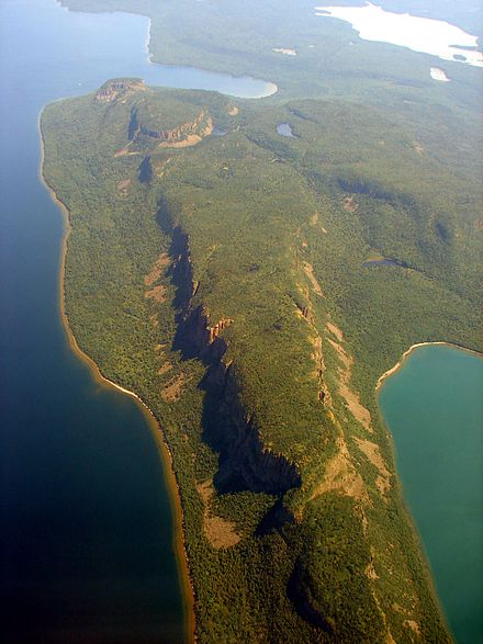
The Sleeping Giant is a series of mesas formed by the erosion of thick, basaltic sills on Sibley Peninsula which resembles a giant lying on its back when viewed from the west to north-northwest section of Thunder Bay, Ontario, Canada. As one moves southward along the shoreline toward Sawyer's Bay the Sleeping Giant starts to separate into its various sections. Most distinctly in the view from the cliffs at Sawyer's Bay the Giant appears to have an Adam's Apple. The formation is part of Sleeping Giant Provincial Park. Its dramatic steep cliffs are among the highest in Ontario (250 m). The southernmost point is known as Thunder Cape, depicted by many early Canadian artists such as William Armstrong.
One Ojibway legend identifies the giant as Nanabijou, who was turned to stone when the secret location of a rich silver mine now known as Silver Islet was disclosed to white men.[3]
Sleeping Giant is the namesake and general setting of the 2015 Canadian film Sleeping Giant.
Seven Wonders of Canada
It was voted number one for a list of Seven Wonders of Canada, with a total of 177,305 votes, beating the Bay of Fundy and Niagara Falls by almost 90 000 votes.[4] Ultimately it was not selected by the panel of judges, Ra McGuire, Roberta Jamieson and Roy MacGregor, who decided their vote by geographic and poetic criteria[citation needed] .
See also
References
- Ontario Parks Sleeping Giant Background Information (2003) Queen's Printer for Ontario. ISBN 0-7794-3989-9. Retrieved on 26 September 2007.
- ^ Elevation data obtained from Ontario Basic Mapping. Retrieved on 26 September 2007.
- ^ Natural Resources Canada Geonames Query - The Sleeping Giant. Retrieved on 26 September 2007.
- ^ The Legend of the Sleeping Giant
- ^ CBC's Seven Wonders of Canada Results Page, accessed 6 June 07
External links
- Information on the Sleeping Giant Provincial Park
- Sleeping Giant Background Information
- Information from the City of Thunder Bay on the Park
This Northern Ontario geographical article is a stub. You can help Wikipedia by expanding it. |