Santa María del Mar District (Peru): Difference between revisions
No edit summary |
Miguel Chong (talk | contribs) No edit summary |
||
| Line 36: | Line 36: | ||
| leader_party = |
| leader_party = |
||
| leader_title = [[Mayor]] |
| leader_title = [[Mayor]] |
||
| leader_name = |
| leader_name = Jiries Jamis Sumar<br> <small>(2019-2022)</small> |
||
| unit_pref = Metric<!-- or US or UK --> |
| unit_pref = Metric<!-- or US or UK --> |
||
| area_footnotes = |
| area_footnotes = |
||
| Line 55: | Line 55: | ||
| footnotes = |
| footnotes = |
||
}} |
}} |
||
'''Santa María del Mar District''' ({{lang-es|Distrito de Santa María del Mar}}) is a [[district]] in southern [[Lima Province]] in [[Peru]]. It is bordered by the [[Pacific Ocean]] on the west, the district of [[San Bartolo District|San Bartolo]] on the north, the [[Chilca District, Cañete|Chilca District]] of the [[Cañete Province]] on the east, and the [[Pucusana District]] on the south. |
'''Santa María del Mar District''' ({{lang-es|Distrito de Santa María del Mar}}) is a [[district]] in southern [[Lima Province]] in [[Peru]]. It is bordered by the [[Pacific Ocean]] on the west, the district of [[San Bartolo District|San Bartolo]] on the north, the [[Chilca District, Cañete|Chilca District]] of the [[Cañete Province]] on the east, and the [[Pucusana District]] on the south. |
||
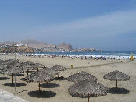
[[File:Santa María del Mar 2.JPG|thumb|280px|left|Panoramic view of Santa María del Mar]] |
[[File:Santa María del Mar 2.JPG|thumb|280px|left|Panoramic view of Santa María del Mar]] |
||
| Line 66: | Line 65: | ||
[[Image:Street in santa maria del mar.jpg|thumb|Street in Santa María del Mar]] |
[[Image:Street in santa maria del mar.jpg|thumb|Street in Santa María del Mar]] |
||
Santa María del Mar began as part of the [[San Bartolo District]], but after an urbanization process that started in 1943, it became a district in 1962.{{clear}} |
Santa María del Mar began as part of the [[San Bartolo District]], but after an urbanization process that started in 1943, it became a district in 1962.{{clear}} |
||
== See also == |
|||
* [[Administrative divisions of Peru]] |
|||
==External links== |
==External links== |
||
{{commonscat}} |
|||
* {{es icon}} [http://www.stamariadelmar.gob.pe Municipality of Santa María del Mar] |
* {{es icon}} [http://www.stamariadelmar.gob.pe Municipality of Santa María del Mar] |
||
| Line 74: | Line 77: | ||
{{DEFAULTSORT:Santa Maria del Mar (Peru)}} |
{{DEFAULTSORT:Santa Maria del Mar (Peru)}} |
||
[[Category:Districts of Lima]] |
[[Category:Districts of Lima]] |
||
{{LimaRegion-geo-stub}} |
{{LimaRegion-geo-stub}} |
||
Revision as of 01:55, 25 February 2019
Santa María del Mar District
Distrito de Santa María del Mar | |
|---|---|
 Santa María beach | |
Location of Santa María del Mar District in Lima Province | |
| Coordinates: 12°25′S 76°47′W / 12.417°S 76.783°W | |
| Country | |
| Region | Lima |
| Province | Lima |
| Founded | January 16, 1962 |
| Government | |
| • Mayor | Jiries Jamis Sumar (2019-2022) |
| Area | |
| • Total | 9.81 km2 (3.79 sq mi) |
| Population (2002 est.) | |
| • Total | 264 |
| • Density | 27/km2 (70/sq mi) |
| Time zone | UTC-5 (PET) |
| UBIGEO | 150138 |
| Website | stamariadelmar.gob.pe |
Santa María del Mar District (Spanish: Distrito de Santa María del Mar) is a district in southern Lima Province in Peru. It is bordered by the Pacific Ocean on the west, the district of San Bartolo on the north, the Chilca District of the Cañete Province on the east, and the Pucusana District on the south.


It is well known for its beaches and attracts many beachgoers every summer. Many of them also rent apartments during this season, making its population increase considerably. The district has some restaurants and a club with a large seawater swimming pool. The most popular beaches in the district are Santa María and Embajadores.
History

Santa María del Mar began as part of the San Bartolo District, but after an urbanization process that started in 1943, it became a district in 1962.
See also
External links
This Lima Region geography article is a stub. You can help Wikipedia by expanding it. |