Savin Hill: Difference between revisions
m Corrected the line about the gay community which equated it with gentrification. |
m Moving Category:1630 establishments in Massachusetts to Category:1630 establishments in the Massachusetts Bay Colony per Wikipedia:Categories for discussion/Log/2023 June 4#Years in Massachusetts |
||
| (19 intermediate revisions by 16 users not shown) | |||
| Line 1: | Line 1: | ||
{{other uses}} |
|||
{{two other uses|the neighborhood in [[Dorchester, Massachusetts]]|the album by the [[Street Dogs]]|Savin Hill (album)|the subway station|Savin Hill (MBTA station)}} |
|||
{{Use mdy dates|date=January 2016}} |
|||
| ⚫ | |||
{{Infobox NRHP |
|||
| ⚫ | |||
| ⚫ | |||
| ⚫ | |||
| ⚫ | |||
| ⚫ | |||
| nocat = yes |
|||
| ⚫ | |||
| ⚫ | |||
| lat_degrees = 42 |
|||
| ⚫ | |||
| lat_minutes = 18 |
|||
| ⚫ | |||
| lat_seconds = 33 |
|||
| coordinates = {{coord|42|18|33|N|71|3|1|W|display=inline,title}} |
|||
| lat_direction = N |
|||
| ⚫ | |||
| long_degrees = 71 |
|||
| ⚫ | |||
| long_minutes = 3 |
|||
| ⚫ | |||
| long_seconds = 1 |
|||
| ⚫ | |||
| long_direction = W |
|||
| ⚫ | |||
| ⚫ | |||
| ⚫ | |||
| ⚫ | |||
| ⚫ | |||
| ⚫ | |||
| ⚫ | |||
| governing_body = State |
|||
| ⚫ | |||
<ref name="nris">{{NRISref|2008a}}</ref> |
<ref name="nris">{{NRISref|2008a}}</ref> |
||
}} |
}} |
||
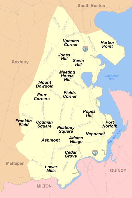
[[Image:Dorchester MA Neighborhoods.png|thumb|300px|Map showing the locations of Dorchester neighborhoods including Savin Hill]] |
[[Image:Dorchester MA Neighborhoods.png|thumb|300px|Map showing the locations of Dorchester neighborhoods including Savin Hill]] |
||
'''Savin Hill''' is a section of [[Dorchester, |
'''Savin Hill''' is a section of [[Dorchester, Boston|Dorchester]], the largest neighborhood of [[Boston, Massachusetts]], [[United States]].<ref>In Boston, the large areas such as Dorchester, Jamaica Plain and Hyde Park are called "neighborhoods" although each contains many smaller areas which are neighborhoods in the common sense of the word in the United States.</ref> |
||
Named after the geographic feature it covers and surrounds, Savin Hill is about one square mile in area, and has a population of about 15,000 people. Savin Hill Beach and Malibu Beach are nearby and are a resource for surrounding communities. Rail and bus routes give access to and from Savin Hill, especially the [[Savin Hill (MBTA station)|Savin Hill station]]. |
Named after the geographic feature it covers and surrounds, Savin Hill is about one square mile in area, and has a population of about 15,000 people. Savin Hill Beach and Malibu Beach are nearby and are a resource for surrounding communities. Rail and bus routes give access to and from Savin Hill, especially the [[Savin Hill (MBTA station)|Savin Hill station]]. |
||
It is the home of the Savin Hill Yacht Club which was founded in 1875 as the ''Savin Hill Beach Association'' but later changed its name in 1888.<ref>Savin Hill Yacht Club, [http://savinhillyc.org/index.php?option=com_content&task=view&id=16&Itemid=30 Savin Hill Yacht Club History]</ref> The club is located off [[Morrissey Boulevard]], a main artery in the area. |
It is the home of the Savin Hill Yacht Club which was founded in 1875 as the ''Savin Hill Beach Association'' but later changed its name in 1888.<ref>Savin Hill Yacht Club, [http://savinhillyc.org/index.php?option=com_content&task=view&id=16&Itemid=30 Savin Hill Yacht Club History] {{webarchive|url=https://web.archive.org/web/20080203094040/http://savinhillyc.org/index.php?option=com_content&task=view&id=16&Itemid=30 |date=February 3, 2008 }}</ref> The club is located off [[Morrissey Boulevard]], a main artery in the area. |
||
== History == |
== History == |
||
The Neponset Indians, a part of the larger [[Massachusett]] tribe |
The Neponset Indians, a part of the larger [[Massachusett]] tribe,<ref>{{cite web | title = Massachusett History | work = First Nations/First Peoples issues | publisher = Jordan S. Dill | url = http://www.dickshovel.com/massa.html | accessdate = March 30, 2007}}</ref> spent their summers in Savin Hill for centuries before the arrival of Europeans.<ref>Cf. City of Boston, [http://www.waymarking.com/waymarks/WM39KX "Savin Hill 500 Years Ago"] - year 2000 commemorative plaque on the building at Sydney & Savin Hill Blvd with murals depicting the native indians by the artist James Hobin.</ref> [[John Smith of Jamestown|Captain John Smith]] of Virginia, the first English settler in America, visited Dorchester in 1614, and had commerce with the Neponset Indians.<ref>[http://bos-gw.rays-place.com/hs-dorchester.htm "Historical Sketch of Dorchester"], Boston : Mercantile Publishing Company, 1888.</ref> |
||
Savin Hill was settled and founded in June |
Savin Hill was settled and founded in June 1630, just a few months before Boston was settled. |
||
The first people arriving in the area were [[Puritan]]s who came on the "Mary and John" from England. They had formerly settled further south on the coast, in the [[Hull, Massachusetts|Hull]] area, before moving north to a hill overlooking a protected harbor, now called [[Dorchester Bay (Boston Harbor)|Dorchester Bay]]. |
The first non-native people arriving in the area were [[Puritan]]s who came on the "Mary and John" from England. They had formerly settled further south on the coast, in the [[Hull, Massachusetts|Hull]] area, before moving north to a hill overlooking a protected harbor, now called [[Dorchester Bay (Boston Harbor)|Dorchester Bay]]. |
||
They landed in boats and built a settlement for approximately 140 people near what is today the intersection of Grampian Way and Savin Hill Avenue. Originally, the area was named Rock Hill. |
They landed in boats and built a settlement for approximately 140 people near what is today the intersection of Grampian Way and Savin Hill Avenue. Originally, the area was named Rock Hill. |
||
| Line 47: | Line 42: | ||
After the [[American Civil War]], the Worthington family, who owned most of the land in present-day Savin Hill, started selling house lots. At that time, most of the Victorian homes that line the slope of the hill were constructed. |
After the [[American Civil War]], the Worthington family, who owned most of the land in present-day Savin Hill, started selling house lots. At that time, most of the Victorian homes that line the slope of the hill were constructed. |
||
[[File:Situationsplan von Boston (Massachusetts).jpg|thumb| |
[[File:Situationsplan von Boston (Massachusetts).jpg|thumb|300px|right|1888 German map of Boston Harbor showing Dorchester in the lower left hand corner.]] |
||
Transportation influenced the development of the neighborhood. The Shawmut Branch Railroad provided a connection to downtown Boston starting in 1872. It was soon acquired by the [[Old Colony Railroad]]. [[Savin Hill (MBTA station)|Savin Hill Station]] became part of Boston's rapid transit network in 1927, now operated as the [[Red Line (MBTA)|MBTA Red Line]]. |
Transportation influenced the development of the neighborhood. The Shawmut Branch Railroad provided a connection to downtown Boston starting in 1872. It was soon acquired by the [[Old Colony Railroad]]. [[Savin Hill (MBTA station)|Savin Hill Station]] became part of Boston's rapid transit network in 1927, now operated as the [[Red Line (MBTA)|MBTA Red Line]]. |
||
When it was separated from the ocean by Morrissey Boulevard in the early 1930s, Savin Hill became a clearly defined area within Dorchester. The distinct nature of the hill itself was made more evident by the trench of the [[Southeast Expressway (Boston)|Southeast Expressway]] (Interstate 93) in the late 1950s. Today, this original area is often referred to |
When it was separated from the ocean by Morrissey Boulevard in the early 1930s, Savin Hill became a clearly defined area within Dorchester. The distinct nature of the hill itself was made more evident by the trench of the [[Southeast Expressway (Boston)|Southeast Expressway]] (Interstate 93) in the late 1950s. Today, this original area is often referred to as Savin Hill "over the bridge," meaning on the east side of where Savin Hill Avenue bridges the Expressway. The full section commonly designated Savin Hill now runs as far west as Pleasant Street, and north-south from Columbia Road to Hancock Street. |
||
| ⚫ | Its relative isolation, solid and often historically significant housing stock, and proximity to downtown Boston have helped make Savin Hill one of the areas of Dorchester which has undergone the most [[gentrification]] in recent years.<ref>Wangsness, Lisa and Silva, Cristina (June 29, 2005) [http://www.boston.com/news/local/articles/2005/06/29/vietnamese_see_role_lost_in_translation/?page=2 Vietnamese see role lost in translation]. ''Boston Globe''</ref> Many of the neighborhood's traditional two- and three-family houses have been converted to individually owned condominiums since the late 1990s.<ref>{{cite news| url=http://www.boston.com/realestate/news/articles/2006/04/22/multifamily_home_sales_boom_ends_4_year_run/ | work=The Boston Globe | title=Multifamily-home sales boom ends 4-year run | date=April 22, 2006 | first=Kimberly | last=Blanton}}</ref> |
||
Savin Hill's population for most of the 20th century consisted primarily of white middle- and working-class families, most prominently [[Irish-Americans]]. Recent decades have seen a large influx of Vietnamese residents and businesses on and around Dorchester Avenue, in addition to increasing numbers of African-Americans and immigrants from [[Latin America]] and the [[Caribbean]] islands.{{Citation needed|date=April 2008}} A gay community has become more visible in recent years. |
|||
| ⚫ | Its relative isolation, solid and often historically significant housing stock, and proximity to downtown Boston have helped make Savin Hill one of the areas of Dorchester which has undergone the most [[gentrification]] in recent years.<ref>[http://www.boston.com/news/local/articles/2005/06/29/vietnamese_see_role_lost_in_translation/?page=2 Boston Globe |
||
Due to its historic character the entire neighborhood was listed on the [[National Register of Historic Places]] in 2003. |
Due to its historic character the entire neighborhood was listed on the [[National Register of Historic Places]] in 2003. |
||
| Line 62: | Line 55: | ||
*[[National Register of Historic Places listings in southern Boston, Massachusetts]] |
*[[National Register of Historic Places listings in southern Boston, Massachusetts]] |
||
== |
==References== |
||
{{reflist| |
{{reflist|30em}} |
||
== Bibliography == |
== Bibliography == |
||
* Giordano, Alice, [http://www.highbeam.com/doc/1P2-8672096.html "A Re-awakening of Savin Hill: Dorchester Neighborhood is Undergoing a Rebirth"], The Boston Globe, September 23, 2001 |
* Giordano, Alice, [https://web.archive.org/web/20121022151426/http://www.highbeam.com/doc/1P2-8672096.html "A Re-awakening of Savin Hill: Dorchester Neighborhood is Undergoing a Rebirth"], The Boston Globe, September 23, 2001 |
||
*Sammarco, Anthony Mitchell, |
*Sammarco, Anthony Mitchell, |
||
** "Boston's South End", Images of America series, Arcadia Publishing, 1998. |
** "Boston's South End", Images of America series, Arcadia Publishing, 1998. |
||
| Line 73: | Line 66: | ||
== External links == |
== External links == |
||
*[http://www.ci.boston.ma.us/bra/pdf/maps/savinhill.pdf Map of Savin Hill neighborhood] |
|||
*[http://www.dorchesteratheneum.org/ Dorchester Atheneum] - Dorchester history |
*[http://www.dorchesteratheneum.org/ Dorchester Atheneum] - Dorchester history |
||
*[http://columbiasavinhillcivic.org/the-neighborhood/ Columbia-Savin Hill Civic Association] |
|||
*[http://openarchives.umb.edu/cdm/singleitem/collection/p15774coll8/id/264/rec/161 Savin Hill Improvement Association records, 1967-1971], University Archives and Special Collections, Joseph P. Healey Library, [[University of Massachusetts Boston]] |
|||
*[http://openarchives.umb.edu/cdm/singleitem/collection/p15774coll8/id/192/rec/4 Columbia-Savin Hill Civic Association records, 1967-1982], University Archives and Special Collections, Joseph P. Healey Library, [[University of Massachusetts Boston]] |
|||
{{BostonMA}} |
{{BostonMA}} |
||
{{National Register of Historic Places in Massachusetts}} |
{{National Register of Historic Places in Massachusetts}} |
||
{{University of Massachusetts Boston}} |
|||
[[Category:Historic districts in Suffolk County, Massachusetts]] |
[[Category:Historic districts in Suffolk County, Massachusetts]] |
||
[[Category:Neighborhoods in Boston |
[[Category:Neighborhoods in Boston]] |
||
[[Category:Dorchester, Boston]] |
[[Category:Dorchester, Boston]] |
||
[[Category:Irish-American neighborhoods]] |
[[Category:Irish-American neighborhoods]] |
||
[[Category:Streetcar suburbs]] |
[[Category:Streetcar suburbs]] |
||
[[Category:Populated places established in 1630]] |
[[Category:Populated places established in 1630]] |
||
[[Category:1630 establishments in Massachusetts]] |
[[Category:1630 establishments in the Massachusetts Bay Colony]] |
||
[[Category:National Register of Historic Places in Boston |
[[Category:National Register of Historic Places in Boston]] |
||
[[Category:Historic districts on the National Register of Historic Places in Massachusetts]] |
|||
Latest revision as of 04:53, 21 June 2023
Savin Hill Historic District | |
 A view into the neighborhood from the park encompassing the top of Savin Hill | |
  | |
| Location | Boston, Massachusetts |
|---|---|
| Coordinates | 42°18′33″N 71°3′1″W / 42.30917°N 71.05028°W |
| Architect | multiple |
| Architectural style | Greek Revival, Gothic Revival |
| NRHP reference No. | 03000385 [1] |
| Added to NRHP | May 9, 2003 |
Savin Hill is a section of Dorchester, the largest neighborhood of Boston, Massachusetts, United States.[2]
Named after the geographic feature it covers and surrounds, Savin Hill is about one square mile in area, and has a population of about 15,000 people. Savin Hill Beach and Malibu Beach are nearby and are a resource for surrounding communities. Rail and bus routes give access to and from Savin Hill, especially the Savin Hill station.
It is the home of the Savin Hill Yacht Club which was founded in 1875 as the Savin Hill Beach Association but later changed its name in 1888.[3] The club is located off Morrissey Boulevard, a main artery in the area.
History
[edit]The Neponset Indians, a part of the larger Massachusett tribe,[4] spent their summers in Savin Hill for centuries before the arrival of Europeans.[5] Captain John Smith of Virginia, the first English settler in America, visited Dorchester in 1614, and had commerce with the Neponset Indians.[6]
Savin Hill was settled and founded in June 1630, just a few months before Boston was settled.
The first non-native people arriving in the area were Puritans who came on the "Mary and John" from England. They had formerly settled further south on the coast, in the Hull area, before moving north to a hill overlooking a protected harbor, now called Dorchester Bay.
They landed in boats and built a settlement for approximately 140 people near what is today the intersection of Grampian Way and Savin Hill Avenue. Originally, the area was named Rock Hill.
By the 1780s, the name changed to Old Hill, a time when the United States was in its infancy.
The original boundary of Dorchester extended almost to the Rhode Island border. As time went on, settlements broke away and the geographical size of the town continued to shrink until 1870, when it disappeared on paper. In that year, the town of Dorchester was incorporated into the city of Boston, and the name became the designation of a neighborhood. By then, the rocky hill where the Puritans first settled had changed its name again, this time to Savin Hill.
Joseph Tuttle, a local innkeeper, who had opened a luxurious hotel at what is today the intersection of Savin Hill Avenue and Tuttle Street, invented the new title "Savin Hill" in 1819, which he named after the red juniper trees (Savin trees) that grew abundantly in the area.
After the American Civil War, the Worthington family, who owned most of the land in present-day Savin Hill, started selling house lots. At that time, most of the Victorian homes that line the slope of the hill were constructed.

Transportation influenced the development of the neighborhood. The Shawmut Branch Railroad provided a connection to downtown Boston starting in 1872. It was soon acquired by the Old Colony Railroad. Savin Hill Station became part of Boston's rapid transit network in 1927, now operated as the MBTA Red Line.
When it was separated from the ocean by Morrissey Boulevard in the early 1930s, Savin Hill became a clearly defined area within Dorchester. The distinct nature of the hill itself was made more evident by the trench of the Southeast Expressway (Interstate 93) in the late 1950s. Today, this original area is often referred to as Savin Hill "over the bridge," meaning on the east side of where Savin Hill Avenue bridges the Expressway. The full section commonly designated Savin Hill now runs as far west as Pleasant Street, and north-south from Columbia Road to Hancock Street.
Its relative isolation, solid and often historically significant housing stock, and proximity to downtown Boston have helped make Savin Hill one of the areas of Dorchester which has undergone the most gentrification in recent years.[7] Many of the neighborhood's traditional two- and three-family houses have been converted to individually owned condominiums since the late 1990s.[8]
Due to its historic character the entire neighborhood was listed on the National Register of Historic Places in 2003.
See also
[edit]References
[edit]- ^ "National Register Information System". National Register of Historic Places. National Park Service. April 15, 2008.
- ^ In Boston, the large areas such as Dorchester, Jamaica Plain and Hyde Park are called "neighborhoods" although each contains many smaller areas which are neighborhoods in the common sense of the word in the United States.
- ^ Savin Hill Yacht Club, Savin Hill Yacht Club History Archived February 3, 2008, at the Wayback Machine
- ^ "Massachusett History". First Nations/First Peoples issues. Jordan S. Dill. Retrieved March 30, 2007.
- ^ Cf. City of Boston, "Savin Hill 500 Years Ago" - year 2000 commemorative plaque on the building at Sydney & Savin Hill Blvd with murals depicting the native indians by the artist James Hobin.
- ^ "Historical Sketch of Dorchester", Boston : Mercantile Publishing Company, 1888.
- ^ Wangsness, Lisa and Silva, Cristina (June 29, 2005) Vietnamese see role lost in translation. Boston Globe
- ^ Blanton, Kimberly (April 22, 2006). "Multifamily-home sales boom ends 4-year run". The Boston Globe.
Bibliography
[edit]- Giordano, Alice, "A Re-awakening of Savin Hill: Dorchester Neighborhood is Undergoing a Rebirth", The Boston Globe, September 23, 2001
- Sammarco, Anthony Mitchell,
- "Boston's South End", Images of America series, Arcadia Publishing, 1998.
- "Dorchester", Images of America series, Arcadia Publishing, 2000.
- "Dorchester: Then & Now", Arcadia Publishing, 2005.
External links
[edit]- Dorchester Atheneum - Dorchester history
- Columbia-Savin Hill Civic Association
- Savin Hill Improvement Association records, 1967-1971, University Archives and Special Collections, Joseph P. Healey Library, University of Massachusetts Boston
- Columbia-Savin Hill Civic Association records, 1967-1982, University Archives and Special Collections, Joseph P. Healey Library, University of Massachusetts Boston
| Topics |  | ||||||||||||||||
|---|---|---|---|---|---|---|---|---|---|---|---|---|---|---|---|---|---|
| Lists by county | |||||||||||||||||
| Lists by city |
| ||||||||||||||||
| Other lists | |||||||||||||||||
| Campus |
|  |
|---|---|---|
| Chancellors |
| |
| Miscellaneous | ||
Italics indicates interim chancellor | ||
- Historic districts in Suffolk County, Massachusetts
- Neighborhoods in Boston
- Dorchester, Boston
- Irish-American neighborhoods
- Streetcar suburbs
- Populated places established in 1630
- 1630 establishments in the Massachusetts Bay Colony
- National Register of Historic Places in Boston
- Historic districts on the National Register of Historic Places in Massachusetts