Tarsdorf: Difference between revisions
mNo edit summary |
→Villages: Brackets Tags: Mobile edit Mobile web edit |
||
| (19 intermediate revisions by 12 users not shown) | |||
| Line 1: | Line 1: | ||
{{Expand |
{{Expand German|topic=geo|date=December 2020}} |
||
{{Infobox settlement |
{{Infobox settlement |
||
| name = Tarsdorf |
| name = Tarsdorf |
||
| Line 67: | Line 67: | ||
==Geography== |
==Geography== |
||
<span lang="de" dir="ltr">Tarsdorf</span> is located in the <span lang="de" dir="ltr">[[Innviertel]]</span>. Situated at an altitude of 429 metres (1,407 ft), the municipality covers an area of 32.2 km² (12.4 mi²), measuring 7.1 km (4.4 mi) from north to south and 6.8 km (4.2 mi) from east to west. 37.9% of the land is forested, while 54.7% is used for agriculture. The [[Filzmoos|<span lang="de" dir="ltr">Filzmoos</span>]], a [[raised bog]], is located within the municipality. |
|||
Tarsdorf is located in the [[Innviertel]]. About 38 percent of its area consist of forest and 55 percent is made up of farmland. |
|||
==Villages== |
==Villages== |
||
The villages in the municipity are (with population in brackets as at 1 Jan 2020): |
The villages in the municipity are (with population in brackets as at 1 Jan 2020): |
||
{{div col|colwidth=15em}} |
|||
<div style="column-count:3"> |
|||
* Am Anger (69) |
* Am Anger (69) |
||
* Döstling (50) |
* Döstling (50) |
||
* Eckldorf 57 |
* Eckldorf (57) |
||
* Ehersdorf (203) |
* Ehersdorf (203) |
||
* Eichbichl (83) |
* Eichbichl (83) |
||
| Line 95: | Line 96: | ||
* Wolfing (45) |
* Wolfing (45) |
||
* Wupping (51) |
* Wupping (51) |
||
{{div col end}} |
|||
</div> |
|||
==History== |
|||
Finds in the <span lang="de" dir="ltr">Weilhart</span> Forest indicate that the <span lang="de" dir="ltr">Tarsdorf</span> area had already been settled by the [[Neolithic]]. Burial mounds from the [[Hallstatt culture|Hallstatt period]] have been discovered. The area was settled by [[Celts]] around 500 BC. |
|||
In the [[Ancient Rome|Roman era]], the road from [[Salzburg]] to [[Burghausen, Altötting|Burghausen]] led through Tarsdorf. It ran through <span lang="de" dir="ltr">Hofweiden</span>, <span lang="de" dir="ltr">Tarsdorf</span> and <span lang="de" dir="ltr">Hörndl</span>. The remains of a rustic villa, a millstone, shards of bowls, bricks from an underfloor heating system, pieces of plaster and a silver coin, all dating back to the first four centuries AD, have been discovered between <span lang="de" dir="ltr">Hofweiden</span> and <span lang="de" dir="ltr">Tarsdorf</span>. |
|||
In the sixth centuries the immigrating Bajuwars, ancestors of today's Bavarians, cleared large parts of the Weilhart-forest. |
|||
=== Population Development === |
|||
{| class="wikitable" |
|||
|+ |
|||
!Year |
|||
!Population |
|||
|- |
|||
|1869 |
|||
|1.115 |
|||
|- |
|||
|1880 |
|||
|1.128 |
|||
|- |
|||
|1890 |
|||
|1.172 |
|||
|- |
|||
|1900 |
|||
|1.246 |
|||
|- |
|||
|1910 |
|||
|1.231 |
|||
|- |
|||
|1923 |
|||
|1.259 |
|||
|- |
|||
|1934 |
|||
|1.274 |
|||
|- |
|||
|1939 |
|||
|1.202 |
|||
|- |
|||
|1951 |
|||
|1.380 |
|||
|- |
|||
|1961 |
|||
|1.343 |
|||
|- |
|||
|1971 |
|||
|1.517 |
|||
|- |
|||
|1981 |
|||
|1.652 |
|||
|- |
|||
|1991 |
|||
|1.793 |
|||
|- |
|||
|2001 |
|||
|1.938 |
|||
|- |
|||
|2011 |
|||
|1.998 |
|||
|- |
|||
|2020 |
|||
|2.060 |
|||
|} |
|||
==Notable People== |
|||
* [[:de:Richard Puchner|Richard Puchner]] (1883-1965), architect and builder |
|||
* [[:de:Georg Dechant (Politiker, 1884)|Georg Dechant]] (1884-1953), politician, farmer and landlord |
|||
==References== |
==References== |
||
{{reflist}} |
{{reflist}} |
||
==External links== |
|||
{{commons category}} |
*{{commons category-inline}} |
||
{{Cities and towns in Braunau am Inn (district)}} |
{{Cities and towns in Braunau am Inn (district)}} |
||
{{authority control}} |
{{authority control}} |
||
Latest revision as of 13:03, 3 May 2024
You can help expand this article with text translated from the corresponding article in German. (December 2020) Click [show] for important translation instructions.
|
Tarsdorf | |
|---|---|
 | |
 Coat of arms | |
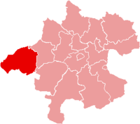
 Tarsdorf Location within Austria | |
| Coordinates: 48°04′48″N 12°49′33″E / 48.08000°N 12.82583°E | |
| Country | Austria |
| State | Upper Austria |
| District | Braunau am Inn |
| Government | |
| • Mayor | Andrea Holzner (ÖVP) |
| Area | |
| • Total | 32.34 km2 (12.49 sq mi) |
| Elevation | 429 m (1,407 ft) |
| Population (2018-01-01)[2] | |
| • Total | 2,068 |
| • Density | 64/km2 (170/sq mi) |
| Time zone | UTC+1 (CET) |
| • Summer (DST) | UTC+2 (CEST) |
| Postal code | 5121 |
| Area code | 06278 |
| Vehicle registration | BR |
| Website | www.tarsdorf.at |
Tarsdorf is a municipality in the district of Braunau am Inn in the Austrian state Upper Austria.
Geography
[edit]Tarsdorf is located in the Innviertel. Situated at an altitude of 429 metres (1,407 ft), the municipality covers an area of 32.2 km² (12.4 mi²), measuring 7.1 km (4.4 mi) from north to south and 6.8 km (4.2 mi) from east to west. 37.9% of the land is forested, while 54.7% is used for agriculture. The Filzmoos, a raised bog, is located within the municipality.
Villages
[edit]The villages in the municipity are (with population in brackets as at 1 Jan 2020):
- Am Anger (69)
- Döstling (50)
- Eckldorf (57)
- Ehersdorf (203)
- Eichbichl (83)
- Fugging (106)
- Haid (48)
- Hofstadt (89)
- Hofweiden (124)
- Hörndl (243)
- Hucking (59)
- Leithen (76)
- Neues Dorf (82)
- Ölling (18)
- Schmidham (38)
- Sensberg (53)
- Sinzing (4)
- Staig (28)
- Tarsdorf (481)
- Wimm (1)
- Winham (52)
- Wolfing (45)
- Wupping (51)
History
[edit]Finds in the Weilhart Forest indicate that the Tarsdorf area had already been settled by the Neolithic. Burial mounds from the Hallstatt period have been discovered. The area was settled by Celts around 500 BC.
In the Roman era, the road from Salzburg to Burghausen led through Tarsdorf. It ran through Hofweiden, Tarsdorf and Hörndl. The remains of a rustic villa, a millstone, shards of bowls, bricks from an underfloor heating system, pieces of plaster and a silver coin, all dating back to the first four centuries AD, have been discovered between Hofweiden and Tarsdorf.
In the sixth centuries the immigrating Bajuwars, ancestors of today's Bavarians, cleared large parts of the Weilhart-forest.
Population Development
[edit]| Year | Population |
|---|---|
| 1869 | 1.115 |
| 1880 | 1.128 |
| 1890 | 1.172 |
| 1900 | 1.246 |
| 1910 | 1.231 |
| 1923 | 1.259 |
| 1934 | 1.274 |
| 1939 | 1.202 |
| 1951 | 1.380 |
| 1961 | 1.343 |
| 1971 | 1.517 |
| 1981 | 1.652 |
| 1991 | 1.793 |
| 2001 | 1.938 |
| 2011 | 1.998 |
| 2020 | 2.060 |
Notable People
[edit]- Richard Puchner (1883-1965), architect and builder
- Georg Dechant (1884-1953), politician, farmer and landlord
References
[edit]- ^ "Dauersiedlungsraum der Gemeinden Politischen Bezirke und Bundesländer - Gebietsstand 1.1.2018". Statistics Austria. Retrieved 10 March 2019.
- ^ "Einwohnerzahl 1.1.2018 nach Gemeinden mit Status, Gebietsstand 1.1.2018". Statistics Austria. Retrieved 9 March 2019.
External links
[edit]Media related to Tarsdorf at Wikimedia Commons
| International | |
|---|---|
| National | |
This Upper Austria location article is a stub. You can help Wikipedia by expanding it. |