Portal:U.S. roads/Selected picture: Difference between revisions
Content deleted Content added
→March, 2006: add April |
→April, 2006: May |
||
| Line 13: | Line 13: | ||
The [[Dalton Highway]] and the [[Alaska Pipeline]] run generally parallel to each other; this segment is between the [[Arctic Circle]] and [[Coldfoot, Alaska|Coldfoot]]. |
The [[Dalton Highway]] and the [[Alaska Pipeline]] run generally parallel to each other; this segment is between the [[Arctic Circle]] and [[Coldfoot, Alaska|Coldfoot]]. |
||
==May, 2006== |
|||
[[Image:Nevada State Highway Signposts Carson Range.jpg|100px]] |
|||
Signposts for [[Nevada State Route 206]] and [[Nevada State Route 207|207]], in front of [[Jobs Peak]] of the [[Carson Range]]. |
|||
Revision as of 00:06, 1 June 2006
Previous selected pictures for the U.S. Roads Portal.
February, 2006
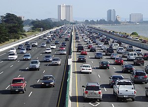
Interstate 80 is a major urban freeway though the East Bay, north of the Bay Bridge, in the San Francisco Bay Area (seen here in Berkeley, California).
March, 2006

Northbound, I-15 makes a steep descent from Mountain Pass into the Ivanpah Valley. In the middle distance, the casinos of Primm straddle the freeway right at the Nevada border, while those of Jean are further off, to the left; Las Vegas is immediately on the far side of the hills on the horizon.
April, 2006

The Dalton Highway and the Alaska Pipeline run generally parallel to each other; this segment is between the Arctic Circle and Coldfoot.
May, 2006

Signposts for Nevada State Route 206 and 207, in front of Jobs Peak of the Carson Range.