Ponce de Leon Avenue: Difference between revisions
→Kroger: splitting off into Kroger on Ponce Avenue |
|||
| Line 36: | Line 36: | ||
In the 1890s-1910s, Ponce de Leon between Midtown and Moreland Avenue (the border of [[Druid Hills]]) was one of the city's premier residential streets lined with large houses of the city's elite. With the arrival of the automobile, the richest families started to move further out, to what is today [[Buckhead (Atlanta)|Buckhead]], to [[Ansley Park]] and to [[Druid Hills]]. Upscale apartment buildings started to appear on the boulevard. Ponce, as did much of the city, lost many of its middle- to upper-middle-class residents in the 1950s and 1960s, and large parking lot areas and new buildings built away from the street made Ponce lose much of the walkability that it had - and its focus gave way fully to automobile traffic. Though a renaissance was beginning in the 1970s, Ponce still was renowned for prostitution, drug sales, but also for its eclectic character up to the turn of the 21st century, celebrated in books such as George Mitchell's ''Ponce Deleon : An Intimate Portrait of Atlanta's Most Famous Avenue'' and Sharon Foster's ''Atlanta's Ponce de Leon Avenue: A History''. Today, the areas that Ponce passes on its way from Midtown to Druid Hills are largely affluent: Midtown, the [[Old Fourth Ward]] where gentrification is well underway, and fully gentrified [[Poncey-Highland]] and [[Virginia-Highland]].<ref>[http://sharonfosterjones.webs.com/poncedeleonavenue.htm Sharon Foster, ''Atlanta's Ponce de Leon Avenue: A History'']</ref> |
In the 1890s-1910s, Ponce de Leon between Midtown and Moreland Avenue (the border of [[Druid Hills]]) was one of the city's premier residential streets lined with large houses of the city's elite. With the arrival of the automobile, the richest families started to move further out, to what is today [[Buckhead (Atlanta)|Buckhead]], to [[Ansley Park]] and to [[Druid Hills]]. Upscale apartment buildings started to appear on the boulevard. Ponce, as did much of the city, lost many of its middle- to upper-middle-class residents in the 1950s and 1960s, and large parking lot areas and new buildings built away from the street made Ponce lose much of the walkability that it had - and its focus gave way fully to automobile traffic. Though a renaissance was beginning in the 1970s, Ponce still was renowned for prostitution, drug sales, but also for its eclectic character up to the turn of the 21st century, celebrated in books such as George Mitchell's ''Ponce Deleon : An Intimate Portrait of Atlanta's Most Famous Avenue'' and Sharon Foster's ''Atlanta's Ponce de Leon Avenue: A History''. Today, the areas that Ponce passes on its way from Midtown to Druid Hills are largely affluent: Midtown, the [[Old Fourth Ward]] where gentrification is well underway, and fully gentrified [[Poncey-Highland]] and [[Virginia-Highland]].<ref>[http://sharonfosterjones.webs.com/poncedeleonavenue.htm Sharon Foster, ''Atlanta's Ponce de Leon Avenue: A History'']</ref> |
||
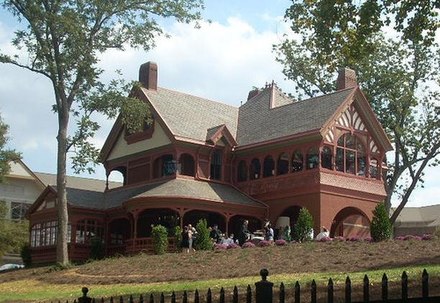
[[Sam Venable]]'s home on the northeast corner of Ponce de Leon Avenue and Oakdale Road was bought in 1959 for $60,000 by the [[St. John's Lutheran Church]]. <ref name=ponce>[http://books.google.com/books?id=5A-502pj08sC&pg=PA67&dq=Venable+Brothers&hl=en&sa=X&ei=-5FFUrnILYS69QTCs4CIAg&ved=0CGMQ6AEwCQ Atlanta's Ponce de Leon Avenue: A History By Sharon Foster Jones</ref> |
|||
==Route== |
==Route== |
||
Revision as of 15:43, 27 September 2013
This article needs additional citations for verification. (December 2011) |
| Ponce | |
| Location | DeKalb, Fulton counties |
|---|---|
| West end | Spring Street (Atlanta) |
| East end | Stone Mountain Lithonia Road |
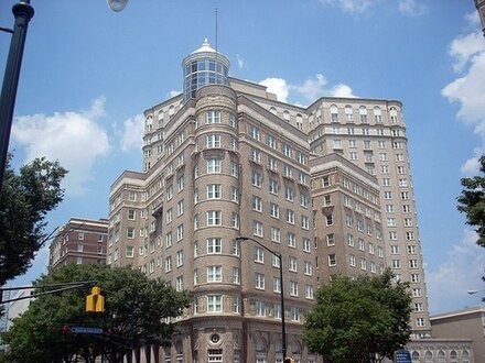
Ponce de Leon Avenue (/p[invalid input: 'ä']nts də ˈl[invalid input: 'ē']ən/ PAHNSS duh LEE-ahn),[1] often simply called Ponce, provides a link between Atlanta, Decatur, Clarkston, and Stone Mountain, Georgia. It was named for Ponce de Leon Springs, in turn from explorer Ponce de Leon, but is not pronounced as in Spanish. Several grand and historic buildings are located on the avenue.
History


The original street extended eastward from Peachtree Street and was called Ponce de Leon Circle. In August 1872, a horsecar line that went from downtown Atlanta up Peachtree to Pine, was extended to Ponce de Leon Circle.[2][3] At some point later it was extended to Ponce de Leon Springs, where the Ponce de Leon amusement park would be built; today, Ponce City Market (formerly the Sears building, then City Hall East) stands on the site. Finally in 1889 the line was electrified and extended with the "loop" around what is now Virginia-Highland.
West of Peachtree Street were Kimball Street and 2nd Street, portions of which were renamed Ponce de Leon Avenue. (see maps at Atlanta annexations)
In the 1890s-1910s, Ponce de Leon between Midtown and Moreland Avenue (the border of Druid Hills) was one of the city's premier residential streets lined with large houses of the city's elite. With the arrival of the automobile, the richest families started to move further out, to what is today Buckhead, to Ansley Park and to Druid Hills. Upscale apartment buildings started to appear on the boulevard. Ponce, as did much of the city, lost many of its middle- to upper-middle-class residents in the 1950s and 1960s, and large parking lot areas and new buildings built away from the street made Ponce lose much of the walkability that it had - and its focus gave way fully to automobile traffic. Though a renaissance was beginning in the 1970s, Ponce still was renowned for prostitution, drug sales, but also for its eclectic character up to the turn of the 21st century, celebrated in books such as George Mitchell's Ponce Deleon : An Intimate Portrait of Atlanta's Most Famous Avenue and Sharon Foster's Atlanta's Ponce de Leon Avenue: A History. Today, the areas that Ponce passes on its way from Midtown to Druid Hills are largely affluent: Midtown, the Old Fourth Ward where gentrification is well underway, and fully gentrified Poncey-Highland and Virginia-Highland.[4]
Sam Venable's home on the northeast corner of Ponce de Leon Avenue and Oakdale Road was bought in 1959 for $60,000 by the St. John's Lutheran Church. [5]
Route
Ponce de Leon Avenue begins at Spring Street at the south edge of Midtown Atlanta, though it may have originally started a block further west at Williams Street (across from Georgia Tech, one block east of Bobby Dodd Stadium) prior to the construction of the Downtown Connector. It passes West Peachtree Street and then Peachtree Street, the city block which has the BellSouth Building (now AT&T) and the historic Fox Theatre on the north side of the street. At the next two intersections, it takes multiple numbered routes from North Avenue, which runs one block to the south and forms the boundary between Midtown and downtown Atlanta. Via one-way Juniper Street southbound and Piedmont Avenue (Georgia 237) northbound, it gets U.S. 29 north, U.S. 78 east, U.S. 278 east, and Georgia 8 east.
After drifting toward the east-northeast, it passes Boulevard (which continues north as Monroe Drive), and after Glen Iris Drive it passes the north side of the old Sears building, which was used as City Hall East and is awaiting redevelopment as Ponce City Market. That building is slated for renovation and redevelopment, as is the rail track on its east side, which will be a part of the BeltLine. After the now-redeveloped Ford Motor Company Assembly Plant on the opposite side of the tracks, it passes the Clermont Lounge and then the north end of Freedom Parkway, where it also picks-up Georgia 10 east. A few blocks further east, it crosses North Highland Avenue by the historic Plaza Theatre, at the intersection which caused the surrounding Atlanta neighborhood to be named Poncey-Highland.
After crossing the intersection of Georgia 42 (Moreland Avenue south and Briarcliff Road north), it gets a sixth route number: U.S. 23 north. Although still within Atlanta city limits, it also crosses the county line from Fulton into DeKalb at this street. The road begins to gradually curve back and forth, and is followed on its south side by South Ponce de Leon Avenue, the land between them being Oak Grove Park. A second segment of linear park is called Dellwood Park, and around Clifton Road it finally leaves the city, just before passing the south side of the Fernbank Museum of Natural History. A third segment called North Ponce de Leon Avenue surrounds a heavily forested county park called Deepdene Park,[6] and on its south side, mainline Ponce de Leon Avenue loses U.S. 278 and Georgia 10 at a split with East Lake Road.
After a northward curve, it loses its other four route numbers at a split with Scott Road, and continues eastward into the city of Decatur as West Ponce de Leon Avenue. Crossing the centerpoint of downtown at Clairemont Avenue (north) and McDonough Street (south), near city hall and the Decatur MARTA station, it becomes East Ponce de Leon Avenue. It then continues on through Scottdale and downtown Clarkston to become Main Street southward through downtown Stone Mountain, then becoming Stone Mountain Lithonia Road on its way south to Lithonia.
It is also an exit at mile 40 off Interstate 285 ("the Perimeter") north. The only way to access I-285 south is to exit onto Church Street, since this is a split-diamond interchange, and the two roads run parallel to each other with a railroad line in between these roads.
The Kroger on Ponce Avenue, nicknamed "Murder Kroger",[7] is a supermarket located in the Poncey-Highland neighborhood and has a checkered history.
Improvements
Ponce de Leon Avenue in the City of Atlanta is included in the Ponce/Moreland Corridors Plan as part of the city's comprehensive development plan.[8]
As of April 2011[update], the Georgia Department of Transportation has decided to begin the design of safety improvements for pedestrians on the two-mile stretch of Ponce between Piedmont and N. Highland/Moreland. Changes proposed include the conversion of an eastbound traffic lane into a two-way left-turn lane. The land would include intermittent traffic islands and "HAWK" pedestrian crossing signals at selected crosswalks where no traffic signals currently exist.[9]
Major intersections
as East Ponce de Leon Avenue (Decatur east to Stone Mountain)
| County | Location | Roads Intersected | Notes |
|---|---|---|---|
| DeKalb | Decatur | Clairemont Avenue | Western terminus; road continues from West Ponce de Leon Avenue |
| Church Street | |||
| North Arcadia Avenue / Sams Crossing | Avondale MARTA Transit Station | ||
| DeKalb Industrial Way | DeVry Technical Institute | ||
| Scottdale | North Clarendon Avenue | ||
| North Decatur Road | |||
| Valley Brook Road | To North DeKalb Mall | ||
| McLendon Drive | |||
| Clarkston |
| ||
| North Indian Creek Drive | |||
| Brockett Road | |||
| Clarkston / Tucker | Idlewood Road | ||
| Stone Mountain | Rays Road | ||
| Hambrick Road | Hambrick Elementary School | ||
| Mountain Industrial Boulevard / North Hairston Road | To Tucker | ||
| Rock Mountain Boulevard | |||
| To | |||
| James B. Rivers Memorial Drive | Eastern terminus Road continues as Main Street |
References
- ^ Template:USdict
- ^ William Bailey Williford, Peachtree Street, Atlanta
- ^ "Many Streets Get New Names", Atlanta Constitution, October 17, 1903
- ^ Sharon Foster, Atlanta's Ponce de Leon Avenue: A History
- ^ [http://books.google.com/books?id=5A-502pj08sC&pg=PA67&dq=Venable+Brothers&hl=en&sa=X&ei=-5FFUrnILYS69QTCs4CIAg&ved=0CGMQ6AEwCQ Atlanta's Ponce de Leon Avenue: A History By Sharon Foster Jones
- ^ http://www.atlantaolmstedpark.org/deepdene.htm
- ^ Thomas Wheatley (April 6, 2011). "Murder Kroger to get a makeover? Grocer says 'no'" Creative Loafing. Accessed September 12, 2013.
- ^ City of Atlanta, Ponce de Leon / Moreland Avenue Corridors Study
- ^ PEDS Newsletter, April 2011