Kallang
Template:Infobox Singapore neighbourhood Kallang is an urban planning area and a subdivision located in the Central Region of Singapore. It is probably best known for being the location of the Singapore Indoor Stadium, the old National Stadium, as well as the new Singapore Sports Hub. It is also where Singapore's first civilian airport, Kallang Airport, was located.
Unlike other towns in Singapore, the commercial hub of Kallang is not located in the vicinity of the Kallang MRT Station. The Singapore Sports Hub, aside from being a sports complex, also houses several shopping malls and entertainment facilities, such as the Kallang Wave Mall, the Leisure Park Kallang and the Kallang Theatre.
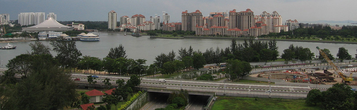
Throughout its history, Kallang was home to several landmarks of Singapore. The country's first civilian airport, the Kallang Airport, was located in Kallang. In addition, the old National Stadium and the former Kallang Gasworks were located at Stadium Boulevard and Kallang Road respectively. Some of Singapore's earliest settlements were also located in Kallang, mostly along the Kallang River and around the Kallang Basin. Today, Kallang is probably best known for being the location of the Singapore Indoor Stadium and the new Singapore Sports Hub.
Kallang is also known to be the place where the 1964 race riots broke out. More specifically, the riots occurred near the old Kallang Gasworks.
The Kallang River which meanders through the area is famous for its water sports. The source of the river is the Lower Pierce Reservoir and the river mouth is located at Kallang Basin, near to the Merdeka Bridge. At more than 10 kilometres, the Kallang River is the longest river in Singapore. The area is also drained by the Geylang River, Rochor River, Sungei Whampoa and the Pelton Canal.
Kallang, together with the estate of Whampoa, form the larger entity of the HDB town of Kallang/Whampoa. The Kallang Planning Area, however, covers a larger area and includes estates such as Farrer Park and part of Kampong Glam.
Estates
| Name of estates | Location | Structures in the vicinity | Accessibility |
|---|---|---|---|
| Bendemeer | Areas around Boon Keng MRT Station, Serangoon Road, Bendemeer Road, Saint George's Road and Saint Michael's Road | Boon Keng MRT Station, Hong Wen School, Bendemeer Primary School, Bendemeer Secondary School, Northlight School, Kallang Community Club, Kallang Neighbourhood Police Post | Boon Keng MRT Station and buses |
| Kolam Ayer | Estates along Geylang Bahru and Kallang Bahru | Kallang Basin Swimming Complex, Kallang Distripark, Kolam Ayer Community Club and the future Geylang Bahru MRT Station | Buses |
| Kampong Bugis | Areas along Kallang Riverside and south of Kallang Road | Kallang Riverside Park | Buses |
| Tanjong Rhu | Southern Kallang; Singapore Sports Hub and areas along Tanjong Rhu Road | Dunman High School, Stadium MRT Station, Singapore Swimming Club, Singapore Sports Hub, Kallang Theatre, Leisure Park Kallang, Kallang Field, Kallang Cricket Ground and the future Tanjong Rhu MRT Station | Stadium MRT Station and buses |
| Crawford | Areas near to Lavender MRT Station, Nicoll Highway MRT Station, Crawford Street and Beach Road | Kallang Riverside Park, ICA Building, Golden Mile Complex, Kampong Glam, Kampong Glam Community Club | Lavender MRT Station, Nicoll Highway MRT Station and buses |
| Kallang Way | Industrial estates along Kallang Way | Kallang Way Industrial Estate, Pelton Canal | Buses |
| Lavender | Areas around King's George Avenue, Jalan Besar and Lavender Street | Jalan Besar Stadium, People's Association headquarters and the future Bendemeer MRT Station | Lavender MRT Station and buses |
| Mountbatten | Estates along Old Airport Road | Mountbatten MRT Station, Dakota MRT Station, Old Kallang Airport Estate, Kong Hwa School, Broadrick Secondary School, Mountbatten Community Club | Mountbatten MRT Station, Dakota MRT Station and buses |
| Boon Keng | Areas near Kallang MRT Station | Kallang MRT Station, Lorong 1 Geylang Bus Terminal, Geylang West Community Club | Kallang MRT Station and buses |
| Farrer Park | Areas near Farrer Park MRT Station, Jalan Besar, Balestier Road, Rangoon Road, Tessensohn Road and Race Course Road | Farrer Park MRT Station, City Square Mall, KK Women's and Children's Hospital | Farrer Park MRT Station and buses |
Etymology
Kallang is an old Malay reference to the orang laut (people of the sea), called orang biduanda kallang, who lived in the vicinity of the Kallang River and Singapore River. At the time of Raffles' landing in Singapore in 1819, there were about 500 orang biduanda kallang. In 1824, the Temenggung moved the orang kallang to the Pulai River in Johor. They consisted of about 100 families, but in 1847 most of them died of a smallpox epidemic. By 1848, the orang kallang were virtually extinct.
There are other possible meanings for this particular place name. Kallang may also be a corruption of the Malay word kilang, meaning "mill" or factory". There were saw mills and rice mills here. Another explanation for the origin of Kallang is that it is derived from galang, which means "to put a boat on wooden stocks or rollers", an appropriate term as the Kallang area straddles both sides of the Kallang River.
Geography and landmarks
The perimeter of Kallang is made up of MacPherson in the northeast, Toa Payoh in the northwest, Marine Parade in the southeast, Downtown Area in the southwest, Marina East in the south, Novena in the west and Geylang in the east. Kallang is drained by the Kallang, Geylang, Rochor and Whampoa rivers, as well as the Pelton Canal. The Kallang River is the longest river in Singapore and drains into the Kallang Basin. Before land reclamation, the Kallang Basin area was a huge swamp and formed part of Singapore's southern coastline.
Kallang is home to many light industrial estates, such as pipe makers, garment factories. Many heavy industry factories have been relocated away from this area to promote residential use. The high rent in the nearby Central Business District also makes Kallang an attractive location for offices.
The housing estates, constructed by the Housing Development Board (HDB) in Kallang were built in the 1970s and 1980s. Some blocks are planned to be reconstructed under the Selective En bloc Redevelopment Scheme (SERS) to redevelop the area, whose demographics are dominated by the middle-aged. New blocks which are 30 stories high are now prominent in the skyline of the area, with more being planned to be built under the new HDB construction policy. A notable major redevelopment is underway in the Old Kallang Airport Estate, where many of the low-rise blocks have been demolished.
Singapore's first civilian airport, the Kallang Airport, was situated in Kallang. At the time of completion, it was hailed as the "finest airport in the British Empire".
Kallang is also notable for being the location of the old National Stadium and the new Singapore Sports Hub which was built on the same site to replace the former. The famous Kallang Roar could have its roots traced to the old National Stadium.
The Kallang Cricket Ground is another sporting venue located in the district, and has played host to several One Day International cricket matches. In more recent times however, it is mainly used to host domestic competitions, and minor international matches, such as those between Singapore and Malaysia. Kallang Cricket Ground is also the home of Singapore's national cricket team.
The Kallang Riverside Park along the Kallang River is a riverine park managed by the National Parks Board. On the side near to the Singapore Sports Hub is a beach while the other side near to Crawford Street is a pedestrian walkway. The walkway is connected to the Gardens by the Bay at Marina Centre.
Kallang Park Connector is part of the Park Connector Network managed by the National Parks Board. As their name imply, these connectors aim to form a continuous loop which would hopefully connect all the major parks within Singapore. Kallang Park Connector runs parallel to Kallang River, the longest river in Singapore, except the stretch around Woodsville Interchange. It is 7.6 km long and hence the third longest Park connector in Singapore, after Ulu Pandan Park Connector and Coastal Park Connector which are 8.5 km and 8km long respectively.
One landmark in Kallang was the large blue tubular container that marked the location of the Kallang Gasworks. It was completed in 1862, when the piped gas supply was turned on in Singapore. It ceased production in 1997, and Senoko Gasworks took over providing gas. The place has been marked as a historic site by the National Heritage Board. Only Gasholder No. 3, with its structural columns, has been preserved.[1][2]
Jurisdiction
Most parts of Kallang are currently part of the Jalan Besar Group Representation Constituency, as of the 2015 general election. Areas around the Old Kallang Airport Estate and Tanjong Rhu are under the Mountbatten Single Member Constituency. Jalan Besar GRC is maintained by the Jalan Besar Town Council, while Mountbatten SMC is under Marine Parade Town Council.
From 2011 to 2015, Kallang was mostly under the Moulmein-Kallang Group Representation Constituency, which operated the local town council responsible for the general maintenance of the area. Part of the area around Boon Keng MRT Station was under the Whampoa Single Member Constituency, but was also maintained by the Moulmein-Kallang Town Council. Precincts in Tanjong Rhu were under the Mountbatten Single Member Constituency.
Transportation

Due to Kallang's unique location just outside of Singapore's downtown core, the area is well served by Singapore's Mass Rapid Transit and Expressways networks.
Road network
Unlike other towns, the streets in Kallang were not named using the numeric system. They were instead named after the estates of Kallang. Some examples are Boon Keng Road after the estate of Boon Keng, Stadium Boulevard after the Stadium, Old Airport Road and Mountbatten Road after Old Airport and Mountbatten estates respectively, and Tanjong Rhu Road after Tanjong Rhu. Some of the roads around the Jalan Besar area are named after famous people, such as Horne Road which branches out from Kallang Road. The word "Kallang" is also found in roads such as Kallang Bahru, Kallang Road, Kallang Tengah and Kallang Way.
As Kallang was located at the fringe of Downtown Singapore, it has an extensive road network which serves the area well, as well as connecting to other estates and major towns in Singapore. The Pan Island Expressway (PIE), East Coast Parkway (ECP), Kallang-Paya Lebar Expressway (KPE) and Central Expressway (CTE) link Kallang up with Singapore's expressway network. With the CTE, drivers can access the Seletar Expressway (SLE) and Tampines Expressway (TPE) in the north, and Ayer Rajah Expressway (AYE) in the south. The CTE also serves part of the downtown of Singapore.
The following roads connect Kallang to other parts of Singapore:
- Kallang Road links Kallang to the downtown;
- Victoria Street links Kallang to the downtown;
- Geylang Road and Sims Avenue links Kallang to Geylang and Bedok;
- Guillemard Road links Kallang to Geylang;
- Serangoon Road links the ethnic neighbourhood of Little India to Kallang;
- Upper Serangoon Road links Kallang to the towns in northeastern Singapore;
- Jalan Besar links Kallang to Rochor in the city area;
- Crawford Street and Republic Avenue links Kallang to Marina Centre and eventually, the downtown;
- Beach Road links Kallang to the downtown;
- North Bridge Road links Kallang to the downtown;
- Mountbatten Road links Kallang to the East Coast area of Singapore;
- Nicoll Highway links Kallang to the downtown;
- Balestier Road links Kallang to Novena.
The following expressways pass through Kallang:
The following roads run between the estates of Kallang:
- Kallang Bahru serves the estates of Kolam Ayer and Kallang Bahru;
- Geylang Bahru serves the estate of Kolam Ayer;
- Boon Keng Road and Upper Boon Keng Road connect Bendemeer and Boon Keng estates;
- Kallang Way serves the industrial estate of Kallang Basin;
- Kallang Avenue, Kallang Junction and Kallang Place serve the industrial estates along Kallang Avenue;
- Stadium Boulevard, Stadium Walk and Stadium Crescent serve the Singapore Sports Hub;
- Old Airport Road serves the Old Kallang Airport Estate;
- Tanjong Rhu Road serves the neighbourhood of Tanjong Rhu in southern Kallang;
- Lavender Street serves the neighborhood of Lavender;
- Bendemeer Road serves the estate of Bendemeer.
Rail service
Kallang is well served by the Mass Rapid Transit (MRT) system, with several lines passing through and numerous stations located in Kallang. The East West Line, North East Line and Circle MRT Line connects Kallang to other parts of Singapore. Stations in and around Kallang include Kallang MRT Station, Lavender MRT Station, Boon Keng MRT Station, Farrer Park MRT Station, Dakota MRT Station, Mountbatten MRT Station, Stadium MRT Station and Nicoll Highway MRT Station.
Commuters traveling to the Singapore Sports Hub would prefer using the Stadium MRT Station instead of the Kallang MRT Station, even though the latter is within walking distance to the Singapore Sports Hub.
Kallang will also be served by the future Bendemeer MRT Station and Geylang Bahru MRT Station on the Downtown MRT Line, as well as Tanjong Rhu MRT Station on the Thomson-East Coast MRT Line.
Air travel
Kallang was home to Singapore's first airport, opened on 12 June 1937 by Sir Shenton Thomas, the then Governor of Singapore. The airport had the advantages of combined facilities for both land and marine aircraft. Due to an increase in demand the Singapore International Airport was built in Paya Lebar. Kallang Airport ceased operations during the mid-1950s. The airport control building was eventually converted into the People's Association of Singapore HQ on 1 July 1960 and the surrounding area has since been redeveloped.
Schools
A number of schools are located in Kallang. They include Dunman High School, Bendemeer Primary School, Bendemeer Secondary School, Hong Wen School and Northlight School. The temporary school compound for CHIJ Katong Convent is currently located in Kallang, at Geylang Bahru Lane, adjacent to the Kallang Basin Swimming Complex.

References
- ^ Sharon Seow, "Exploring Jalan Besar", Voices@Central Singapore Issue No. 35, Jul/Aug 2007.
- ^ "Speech by Ms Grace Fu, Minister of State for National Development, at the 2006 URA Architectural Heritage Awards Presentation Ceremony". Retrieved 25 September 2006.
Sources
- Victor R Savage, Brenda S A Yeoh (2003), Toponymics – A Study of Singapore Street Names, Eastern Universities Press, ISBN 981-210-205-1
External links
Media related to Kallang Planning Area at Wikimedia Commons
