Michigan Territory
Michigan Territory was an organized territory of the United States in the early 19th century, between June 30, 1805 and January 26, 1837, at which point it became Michigan, the 26th state of the Union. Detroit was the territorial capital.
History and government
Pre-history
After the arrival of Europeans, the area that became the Michigan Territory was first under French and then British control. Following the American Revolutionary War, several states had competing claims on land in the region. In 1779, Virginia established Illinois County with boundaries that encompassed all of the land east of the Mississippi River, north of the Ohio River and west of the Appalachian Mountains. However, the county government for all practical purposes never exercised actual control beyond an area limited to a few old French settlements along the major rivers. Other states also claimed portions of what was to become Michigan, including New York, Connecticut, and Massachusetts.
The several states eventually ceded their claims and in 1787, the Continental Congress created the Northwest Territory. The region that became Michigan was initially unorganized territory. Knox County was established on June 20, 1790 with boundaries that included the western half of the Lower Peninsula of Michigan and most of the Upper Peninsula of Michigan. In 1792, the boundaries of Hamilton County were expanded to include the eastern portions of Michigan not included in Knox County. Wayne County was established August 15, 1796, from Knox and Hamilton counties and included most of the area that later became the Michigan Territory as well as portions of what is now Ohio, Indiana, Illinois, and Wisconsin.
In 1800, the western half of Michigan was attached to Indiana Territory when it was established as a separate government from the Northwest Territory. Wayne County was reduced to the eastern portion of Michigan and remained a part of the Northwest Territory. Knox County had been transferred to the Indiana Territory, and in 1801 its boundaries were expanded to include most of the western part of the Lower Peninsula and a small slice of the Upper Peninsula. St. Clair County, another Indiana Territory county, was also expanded to include the western portion of the Upper Peninsula and a small sliver of the Lower Peninsula along the shore of Lake Michigan.
When Ohio was admitted as a state of the Union in 1803, the eastern half of Michigan was attached to the Indiana Territory. At that time, the old Wayne County technically ceased to exist. A second incarnation of Wayne County was subsequently created from Knox and St. Clair counties, encompassing all of the Lower Peninsula, much of the Upper Peninsula, portions of Illinois, Indiana, and Wisconsin.
Organization
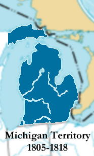
Michigan Territory was established by an act of the United States Congress on January 11, 1805, effective June 30 of that year. The act defined the territory as "all that part of the Indiana Territory, which lies North of a line drawn east from the southerly bend or extreme of lake Michigan, until it shall intersect lake Erie, and East of a line drawn from the said southerly bend through the middle of said lake to its northern extremity, and thence due north to the northern boundary of the United States." The first territorial governor, William Hull abolished Wayne County and established new districts of his own making, which proved to be short-lived. Lewis Cass became governor in 1815 and promptly undid Hull's work and re-established a third incarnation of Wayne County that included all lands within Michigan Territory that had been ceded by Native Americans through the 1807 Treaty of Detroit.
During the War of 1812, following General Isaac Brock's capture of Detroit on August 16, 1812, the Michigan Territory was at least nominally a part of the Province of Upper Canada. On August 24, Colonel Henry Proctor proclaimed the continuation of civil government under existing laws with Proctor acting as Governor and Chief Justice Augustus B. Woodward acting as Secretary. On February 4, 1813, Proctor suspended civil government and imposed martial law.

When Indiana (1816) and Illinois (1818) joined the Union, remnants of their territories were joined to Michigan Territory. An area equal to 30 townships was also transferred from Michigan Territory to Indiana to allow that state access to Lake Michigan. Soon afterward, the federal government rapidly began signing treaties with local Indian tribes and acquiring their lands.
In 1824, the Michigan Territory graduated to the second grade of territorial status, and the government's power was transferred from the Governor and a handful of judges to the people. The people elected 18 to the Legislative Council, of which nine were approved by the President and first sat in council on June 7, 1824. The Council was expanded from nine to 13 in 1825, the 13 being chosen by the President from a field of 26.
The Erie Canal opened in 1825, allowing settlers from New England and New York to reach Michigan by water through Albany.

In 1834, all of the lands acquired in the Louisiana Purchase that were as yet unallocated and lay east of the Missouri River (generally, the Dakotas, Iowa and the western half of Minnesota) were attached to the Michigan Territory, an area that was officially characterized as "north of Missouri and east of the Missouri and White Earth Rivers." At this point, Michigan Territory included what is now the states of Michigan, Wisconsin, Iowa, Minnesota and a large portion of the Dakotas.


Meanwhile, in 1835, the Toledo War was fought with Ohio because Michigan Territory wanted to retain the disputed "Toledo Strip." The Toledo area of Ohio was finally surrendered in exchange for the western section of the Upper Peninsula of Michigan.
Slavery was forbidden in the territory under the Northwest Ordinance, but English and French residents were permitted to retain possession of slaves already owned at the time the territory became organized. Census records in 1810 and 1830 showed double-digit slave populations in the territory, believed in many cases to be enslaved Native Americans rather than enslaved African Americans.
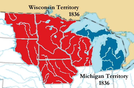
On July 3, 1836, in preparation for Michigan statehood, the Wisconsin Territory was organized from Michigan Territory, consisting of the present states of Wisconsin, Minnesota, Iowa and the eastern portion of the Dakotas. Michigan became a state on January 26, 1837, and included the Upper Peninsula as far west as the Montreal River as part of the resolution to the conflict over the Toledo Strip, which had blocked Michigan statehood for several years. Detroit remained the capital until March 17, 1847 when Lansing was chosen as a replacement. The population of Michigan at the time of statehood is estimated to have been about 200,000, which was well above the Northwest Ordinance's minimum requirement of 60,000.
Territorial acquisition
The area that became Michigan was British territory, and was ceded to the United States in 1783, but was owned by the native peoples of the area. The majority of it was gained by cession, coerced or otherwise. The people resident in Michigan before American settlement were the Ottawa, the Potawatomi, Ojibwa and the Wyandot. Treaties ceding the land were signed between 1795 (the Treaty of Greenville) and 1842 (the Treaty of La Pointe). Other notable treaties were Governor Hull's treaty of 1808, the Treaty of Saginaw in 1819, the two Treaties of Chicago (1821, 1833), the Carey Mission in 1828 and the Treaty of Washington in 1836 and a later treaty of January 4, 1837.
Territorial subdivisions
Wayne County, Michigan, originally part of the vast Northwest Territory, was eventually whittled down into its current size by the separation of several tracts: Monroe in 1817, Michilimackinac County, Michigan (later called Mackinac and subdivided seven times further) and Macomb Counties in 1818, St. Clair and St. Joseph Counties in 1820 and Washtenaw County in 1822. (Chippewa County was created from Mackinac in 1826, four other Michigan counties were eventually created from that land, and other parts went to Minnesota.) The first township organization was Detroit, in Wayne County, in 1802.
Also organized in the territorial period was Showano County, Michigan in 1818, later called Crawford County, Michigan, and originally covering much of what is now Minnesota.
Oakland County, Michigan, which was created in 1819, and later was subdivided into all or parts of Genesee, Lapeer, Sanilac, Shiawassee and Saginaw. Saginaw was then split further, into eight separate counties, three of which, Isabella, Arenac and Midland, were established during the territorial period.
Lenawee County was created in 1822 from what had been Indian lands, and Hillsdale County was separated out in 1829. Other parts of Lenawee were turned into Cass and Berrien. Branch also sprung fully formed from Michigan Territory in 1829.
Kalamazoo County, Michigan, established 1829 from St. Joseph County, was the dominant tract in Western Michigan and was divided and subdivided into many other counties: Allegan, Barry, Calhoun, Eaton, Ionia, Montcalm, Kent, Ottawa and Clinton (some created during the territorial period, others split off later).
Jackson and Ingham were created in 1829 from Washtenaw; Isabella was created from parts of Saginaw and Midland in 1831. Gratiot County was also put together from pieces of Saginaw, and Clinton, in 1831.
Seven of the 12 counties created in 1829 were named for members of President Andrew Jackson's Cabinet, and one was named for Jackson himself.
Iowa County, later in the state of Wisconsin, was established in 1831, and part of it was later returned to Michigan as Keweenaw on the Upper Peninsula.
Brown County, organized 1818 in Michigan Territory, was a huge tract covering a great deal of present-day Wisconsin.
West of the Mississippi River and south of Rock Island, Dubuque and Des Moines Counties were created in Michigan Territory in 1834 and transferred to the Wisconsin Territory in 1836. These areas later became part of Iowa.
Milwaukee County was established in 1834 and was also transferred to Wisconsin in 1836.
Territorial population
These census numbers do not include most Native Americans, defined in the U.S. Constitution as "Indians not taxed" (Article I, Sec. 2). In 1800, the whole of the Northwest Territory had 43,365 residents. Under the Northwest Ordinance, a territory could apply for statehood once it had surpassed 60,000 inhabitants.
| Year | Population |
|---|---|
| 1810 | 4,762 |
| 1820 | 8,896 |
| 1830 | 31,639 |
| 1834 | 87,273 |
| 1840 | 212,267 |
Territorial officers
Governors
| Governor | Dates Served | Notes |
|---|---|---|
| William Hull | March 1, 1805 to October 29, 1813 | |
| Lewis Cass | October 29, 1813 to August 6, 1831 | |
| George Bryan Porter | August 6, 1831 to July 6, 1834 | Died in office. |
| Stevens T. Mason | July 6, 1834 to September 15, 1835 | ex officio, Acting Governor due to position as Secretary |
| John S. Horner | September 15, 1835 to July 3, 1836 | ex officio, Acting Governor due to position as Secretary |
Secretaries
| Secretary | Dates Served |
|---|---|
| Stanley Griswold | March 1, 1805 to March 18, 1808 |
| Reuben Atwater | March 18, 1808 to October 15, 1814 |
| William Woodbridge | October 15, 1814 to January 15, 1828 |
| James Witherell | January 15, 1828 to May 20, 1830 |
| John T. Mason | May 20, 1830 to July 12, 1831 |
| Stevens T. Mason | July 12, 1831 to September 15, 1835 |
| John S. Horner | September 15, 1835 to July 3, 1836 |
Supreme Court
From 1805 through 1823, Territorial Supreme Court Justices were appointed by the U.S. President, with consent of the U.S. Senate. Their terms had no fixed limits. In 1823, the U.S. Congress passed an act reorganizing territorial government and setting a four-year term of office for justices.
| Supreme Court Justices | Dates Served | Notes |
|---|---|---|
| Augustus B. Woodward | March 2, 1805 to February 1, 1824 | Appointed by Thomas Jefferson; resigned following reorganization of court |
| Frederick Bates | March 3, 1805 to November, 1808 | Appointed by Thomas Jefferson; resigned after being appointed Secretary of Louisiana Territory |
| John Griffin | December 23, 1805 to February 1, 1824 | Appointed by Thomas Jefferson; resigned following reorganization of court |
| James Witherell | April 23, 1808 to January 15, 1828 | First appointed by Thomas Jefferson; reappointed by James Monroe; resigned after being appointed Secretary of Michigan Territory |
| Solomon Sibley | February 2, 1824 to July 17, 1836 | First appointed by James Monroe, reappointed by John Quincy Adams and Andrew Jackson; not reappointed after Michigan statehood |
| John Hunt | February 20, 1824 to June 15, 1827 | Twice appointed by James Monroe; died in office |
| Henry C. Chipman | July 18, 1817 to April 25, 1832 | Twice appointed by John Quincy Adams; was not reappointed by Andrew Jackson |
| William Woodbridge | January 15, 1828 to April 25, 1832 | Appointed by John Quincy Adams; was not reappointed by Andrew Jackson |
| Ross Wilkins | April 26, 1832 to July 17, 1836 | Appointed by Andrew Jackson; appointed U.S. District Court judge for Michigan after statehood |
| George Morrell | April 26, 1832 to July 17, 1843 | First appointed by Andrew Jackson; appointed to the Michigan Supreme Court by Governor Mason |
Congressional delegates
In 1819, Michigan Territory was given the authority to elect a Congressional delegate.
| Delegate | Years | Party |
|---|---|---|
| William Woodbridge | 1819-20 (16th Congress) | Whig |
| Solomon Sibley | 1820-23 (16th and 17th Congresses) | |
| Gabriel Richard | 1823-25 (18th Congress) | |
| Austin Eli Wing | 1825-29 (19th and 20th Congresses) | |
| John Biddle | 1829-31 (21st Congress) | |
| Austin Eli Wing | 1831-33 (22nd Congress) | |
| Lucius Lyon | 1833-35 (23rd Congress) | Democratic |
| George Wallace Jones | 1835-37 (24th Congress) | Democratic |
See also
- Historic regions of the United States
- United States congressional delegations from Northwest Territory
- Timeline of the Toledo Strip/War