Fichier:John Duns Scotus - geograph.org.uk - 1178460.jpg
Taille de cet aperçu : 450 × 600 pixels. Autres résolutions : 180 × 240 pixels | 480 × 640 pixels.
Fichier d’origine (480 × 640 pixels, taille du fichier : 54 kio, type MIME : image/jpeg)
Ce fichier et sa description proviennent de Wikimedia Commons.
Description
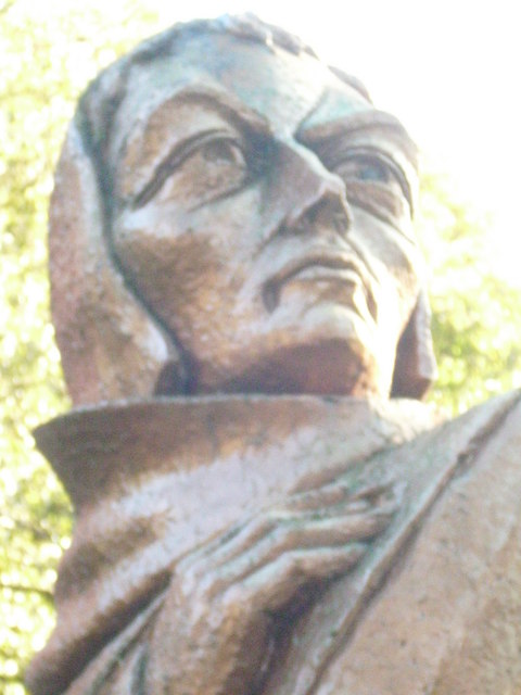
| Description |
English: John Duns Scotus One of Scotland's greatest men and arguably the most forward thinking man of the 13th century. John of Dunse (as it was then spelt) was so controversial because of his forward thinking, many thought he was mad. Hence the word dunse or dunce for a poor scholar. He was educated at the Franciscan Grammar school in Haddington and though he never joined the Franciscan brotherhood,he is revered within that order. There are Duns Scotus colleges on the Continent. This statue stands in the public park of his home town, Duns in Berwickshire. |
| Date | |
| Source | From geograph.org.uk |
| Auteur | james denham |
| Lieu de la prise de vue | | Voir cet endroit et d’autres images sur : OpenStreetMap |
|---|
| Position de l'objet | | Voir cet endroit et d’autres images sur : OpenStreetMap |
|---|
Conditions d’utilisation

|
Cette image provient de la collection du projet Geograph British Isles. Pour obtenir les coordonnées du photographe, veuillez consulter cette page de description de l'image sur le site du projet. Les droits d'auteurs sur cette image sont détenus par james denham ; l'image est placée sous une licence Creative Commons avec mention de paternité et partage à l'identique (CC-By-SA) en version 2.0.
|
Ce fichier est disponible selon les termes de la licence Creative Commons Attribution – Partage dans les Mêmes Conditions 2.0 Générique
Attribution: james denham
- Vous êtes libre :
- de partager – de copier, distribuer et transmettre cette œuvre
- d’adapter – de modifier cette œuvre
- Sous les conditions suivantes :
- paternité – Vous devez donner les informations appropriées concernant l'auteur, fournir un lien vers la licence et indiquer si des modifications ont été faites. Vous pouvez faire cela par tout moyen raisonnable, mais en aucune façon suggérant que l’auteur vous soutient ou approuve l’utilisation que vous en faites.
- partage à l’identique – Si vous modifiez, transformez, ou vous basez sur cette œuvre, vous devez distribuer votre contribution sous la même licence ou une licence compatible avec celle de l’original.
Historique du fichier
Cliquer sur une date et heure pour voir le fichier tel qu'il était à ce moment-là.
| Date et heure | Vignette | Dimensions | Utilisateur | Commentaire | |
|---|---|---|---|---|---|
| actuel | 25 février 2011 à 19:36 | 480 × 640 (54 kio) | GeographBot | == {{int:filedesc}} == {{Information |description={{en|1=John Duns Scotus One of Scotland's greatest men and arguably the most forward thinking man of the 13th century. John of Dunse (as it was then spelt) was so controversial because of his forward think |
Utilisation du fichier
La page suivante utilise ce fichier :
Usage global du fichier
Les autres wikis suivants utilisent ce fichier :
- Utilisation sur af.wikipedia.org
- Utilisation sur ba.wikipedia.org
- Utilisation sur en.wikipedia.org
- Utilisation sur fa.wikipedia.org
- Utilisation sur gl.wikipedia.org
- Utilisation sur it.wikipedia.org
- Utilisation sur ja.wikipedia.org
- Utilisation sur la.wikipedia.org
- Utilisation sur no.wikipedia.org
- Utilisation sur ru.wikipedia.org
- Utilisation sur sco.wikipedia.org
- Utilisation sur sh.wikipedia.org
- Utilisation sur uk.wikipedia.org
- Utilisation sur war.wikipedia.org